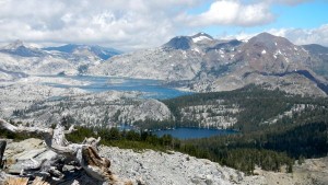
360-degrees of awe from the top of Ralston Peak
By Kathryn Reed
TWIN BRIDGES – Mount Tallac from the South Shore is an impressive icon. But when it comes to looking at Tallac’s backside from the top of Ralston Peak, the grandeur pales in comparison to the razzle-dazzle Mother Nature provides from this vantage point.
It’s so much better than being at the top of Tallac, too, because the vistas are jaw dropping gorgeous. Civilization is nowhere on the horizon unless ski slopes count.
It’s odd feeling like I was in the middle of nowhere and yet knowing exactly where I was. Familiar landmarks surrounded me as I took in the 360-degree view.
Barren runs of Sierra-at-Tahoe; splotches of snow dotting Pyramid Peak – which at 9,983-feet is the highest mountain in the Crystal Range and Desolation Wilderness; the pools of Lake Aloha that resemble a moonscape; Price, Jack and Dick peaks looking manageable to climb from our perch at 9,235 feet; Lake Tahoe so vast it could be the ocean; Fallen Leaf so small it could be Heather Lake.
With 50 mph winds forecast for our destination, we were dressed more like a winter hike than summer. Warmth was not what we found on this last Sunday of June, but that didn’t matter – except that it meant we didn’t linger long.
There are 12 women and two dogs making the trek to the top of Ralston. I was not alone in this being my first excursion up this landmark that can be seen from Highway 50 near Horsetail Falls. While there are several routes to get to the top, we start at Echo Lake.
We cut off two miles each way by taking the boat across. It fits all of us. It costs $12 one-way – each person. The boat shuttle is a racket. They have a captive audience and are clearly ripping people off. That’s the only negative.
The ride is beautiful. Larkin delivers us to the dock on the far side where we begin our 8-mile roundtrip journey. (We start hiking at 8:40am and return to the dock at 3pm.)
It starts out rocky. The runners in the group sprint to the lead. Others fall to the back, taking in the scenery of Tamarack Lake that comes up on our left.
There are lupine, phlox, pussy paws, wallflower, Indian paintbrush, shooting star and sulphur buckwheat to photograph. Wildflowers, while not in abundance, dot the landscape in an array of colors.
At this elevation they are smaller than what is found at lake level – dwarf-like, Kim says.
Winter’s sparse snowfall has turned western-facing manzanita black. Lack of water has killed some of these bushes in the backcountry.
While they are a species that burns hot in a fire, dead manzanita is more susceptible to fire than a live plant. Fire is more of a concern for the manzanita trees because it becomes a ladder fuel, Lauri explains.
Trail signs pop up. So many choices for where to play in Desolation Wilderness. Some of the routes are along the Pacific Crest Trail.
We take the second left headed toward Lake of the Woods. We keep her to our right, never reaching her shore. Pyramid Peak – aptly named because it looks like pharaohs could call this mountain home – looms over this lake.
Pockets of snow crop up, but nothing substantial enough to hinder our progress.
We traipse through a soggy meadow before the last ascent to the tip-top.
Mountain hemlock and white bark pine are sprouting from the rugged terrain. They like it at this elevation.
Giddy with delight of making it to our destination and taking in the scenery, we are all smiles feeling like we are on top of the world.
(Click on photos to enlarge.)


Thanks for this beautiful description and especially the panorama shot. Love it!
why was the boat fee a racket? Maybe it was rather profitably filled, but what about when only 2 backpackers are paying for a ride? If it was that expensive, you all could have walked! Clearly it was worth the $12 to you to not! :)
Nice article Kae. I can always count on you to give me some new hikes. I agree about the Echo Lake shuttle. Last year it was $10 and a few years before that, it was $5. Cost of living hasn’t gone up that much. Pure greed if you ask me.
I always thought of those two miles as a nice, mostly flat, warm-up!