Yosemite — a place for everyone
Publisher’s note: This is one in a series of stories about the National Park Service, which is celebrating its 100th anniversary in 2016. All articles may be found via the Home Page, select Special Projects, then National Park Service 100th.
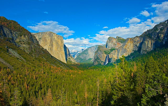
The grandeur of Yosemite is captivating no matter the season. Photo/Yosemite Hospitality
By Joann Eisenbrandt
I grew up loving Yosemite.
I first went there in the 1950s, well before 4 million people visited it each year. It was the best place of my childhood. Every summer, my father, mother and I spent my father’s vacation camping there. We set up our campsite in Camp 14, alongside the Merced River and just across a big meadow from Camp Curry. You could walk out from amongst the closely spaced pines of the campground and stand in the meadow in waist-high grass and look up at the chiseled face of Glacier Point. Or walk across the roadway and through Camp Curry’s grizzled old apple orchard and parking lot to the popular ice cream vendor’s window just around the corner from the Camp Curry cafeteria.
Every evening, just before dark, we’d put on our light sweaters and stand in the meadow to watch the Fire Fall. A massive fire built atop Glacier Point 3,200 feet above was pushed over its steep face. “Let the fire fall,” the echoing call went out as it cascaded down the black and gray granite in a swoosh of blazing embers. The Fire Fall was permanently discontinued in 1968.
During the hot summer days, my mother and I would climb down the sandy banks to the cool Merced River and float downstream on large Army-green air mattresses. They smelled strongly of hot rubber, so we covered them with colorful beach towels. I always fought getting out of the river, even though my mother never failed to remind me what a long hike back upstream it would be. Guided horseback rides from the nearby stables came down a well-trodden path that followed the river’s edge. It was a narrow strip of powdery hot dirt full of stones churned up by years of pounding hooves and punctuated by often-steaming mounds of equine droppings.
My parents loved hiking and climbing and had done a lot of it in Yosemite before I was born. They were fearless. They’d scaled the rope ladder up the back side of Half Dome and gone up the steep trail that twisted from the valley floor to the very top of Glacier Point. They’d scrambled over the massive boulders beneath the bridge below Yosemite Falls all the way up to where the waterfall hit the riverbed. I still have my father’s Kodak camera and the crisp black and white photos of their adventures that it recorded.

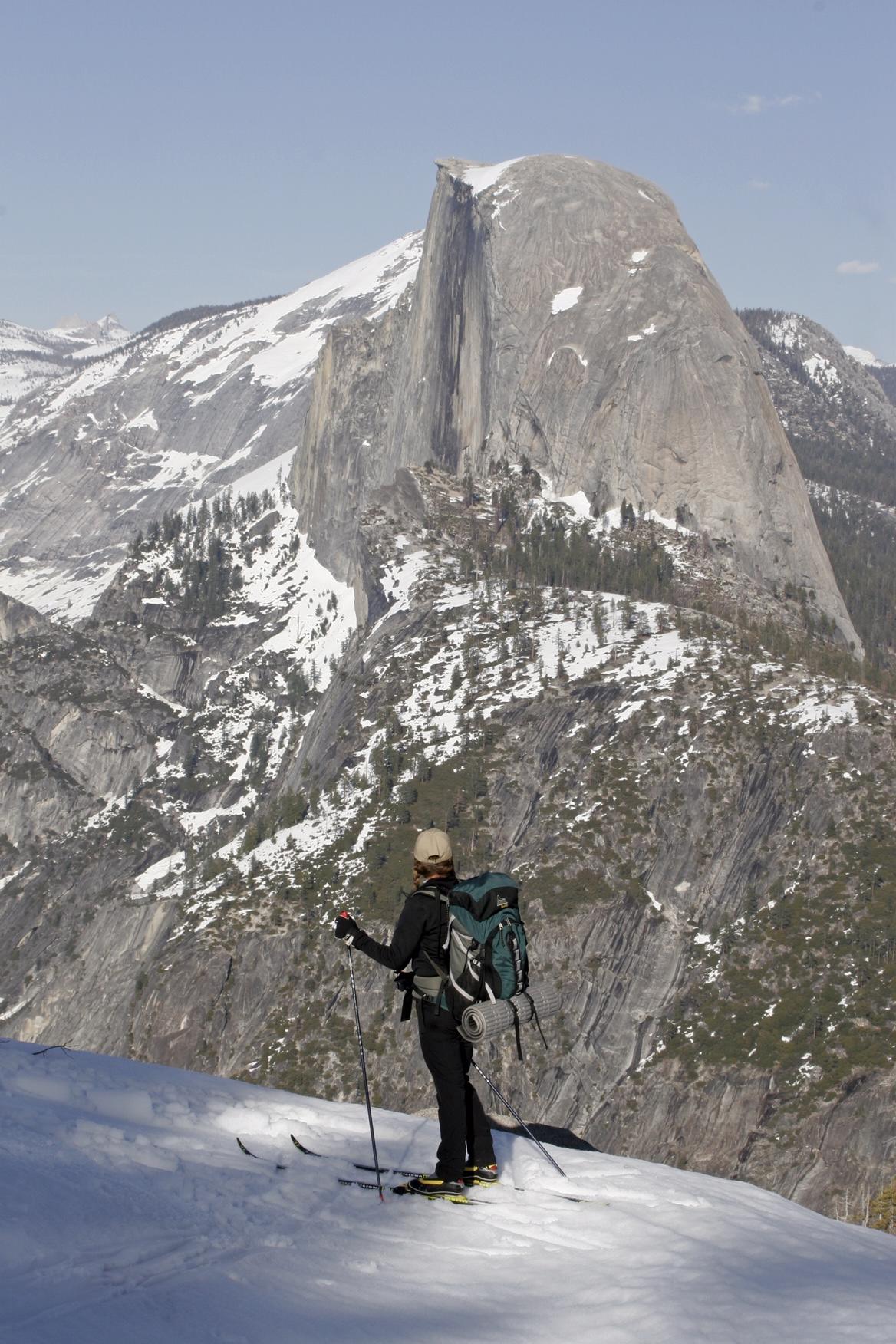
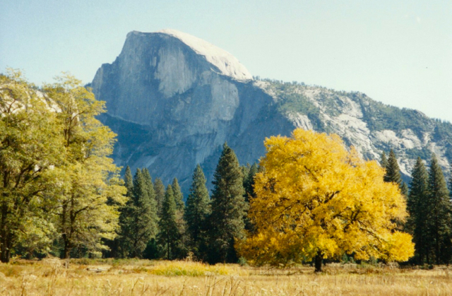
Half Dome from Glacier Point. Photo/George Thomson
I hiked up the 4-mile trail from the valley floor to the top of Glacier Point with my parents. The start of the trail is flanked by monstrous boulders, big as buildings, flung there carelessly by the glaciers that carved out Yosemite eons ago. It was so steep for me that there were many times when my father had to literally push me up to the next plateau. The view from the top was breathtaking. I still compare it to looking over the rim of the Grand Canyon. You can’t imagine what it is like from photos. You have to be there.
We also left Happy Isles and made it all the way up the 7-mile Mist Trail to Vernal and Nevada Falls. It is called the Mist Trail because the mist that rises up as the two falls plunge precipitously down to the rock-strewn riverbed below covers the twisting trail of carved rock steps in a shroud of wet fog and makes it terrifyingly slick. My parents told me that when they hiked the trail years before it was even worse. I found that hard to believe.
In the early 1970s, I moved to Oakhurst in the southern Sierra just outside Yosemite’s southern entrance and was reintroduced to the park as an adult. I reconnected with places from my childhood like Wawona, the Ahwahnee, and Camp Curry. In March 2016, a trademark dispute between Delaware North, Yosemite’s outgoing concessionaire, and the National Park Service brought ownership of those iconic names into question. Delaware North had trademarked them and other park names and wanted the NPS to buy them back for an estimated $51 million. The Park Service disputed the amount, and decided to change the names of these places, at least temporarily, when the new park concessionaire, Aramark, took over.
New place names don’t change the fact that enduring memories of Yosemite stretch back for generations. I certainly have my family memories, and I was lucky to share the even-earlier memories of Eleanor Crooks.
I first met Crooks in the late 1970s when she was already in her 80s. She lived in Ahwahnee, in the Sierra foothills outside Yosemite on a hilltop overlooking a sweeping pine and oak-filled valley. I was writing an article about Wawona for a local lifestyle magazine. She welcomed me warmly into her home. She was relatively petite, but had a lively presence, with the sparkle of youth still in her eyes.
Crooks was the daughter of William Sell. Sell was the first telegraph operator in Yosemite. At the request of Henry Washburn, one of three brothers who owned the Wawona Hotel, Sell built and ran the Ahwahnee Tavern, a rest stop for travelers going into the Yosemite Valley in the late 1890s and early 1900s.

No matter what it’s called, there is something magical about this lodge at Yosemite. Photo/Yosemite Hospitality
Crooks offered me tea and we sat down at a small table in her sunny kitchen to talk. She told me about her years growing up at Ahwahnee Tavern. In 1903, when she was about 7, President Theodore Roosevelt stopped there on his way to meet John Muir in Yosemite. Crooks remembered it as if it were just the other day. She described the chief of state as impatient, yet friendly. She recalled her mother’s dismay when one of Roosevelt’s aides ate all the carefully prepared cookies while the president was out back washing up with the ordinary folks. Despite all their elaborate preparations, Roosevelt didn’t stay the night, but instead rode on the same day, preferring to camp outdoors with Muir in the Mariposa Grove of giant sequoias just inside the park’s southern entrance.
Crooks took horse-drawn stage rides from Ahwahnee into Wawona in what she called a “mud wagon.” These open wagons had that name, she told me, because in wet weather, by the time the passengers arrived at the hotel, they were often so covered with mud as to be almost unrecognizable. “Toward evening,” she remembered, “we arrived at the hotel, with the fountain in the center as it is now. The stage drivers drove up to the steps of the hotel with a great deal of pride. The porters, who were all older men, took the passengers down, dusted them off, and then conducted them up the steps into the lobby.”
“On the porch,” she continued, “the women associated with the hotel would be sitting in their fancy clothes awaiting the arrival of the tourists.” After dinner, there would be singing and sometimes a dance in the dance hall. The next morning, the guests would tour the Big Trees and then continue on down into Yosemite Valley itself.
John Muir was an advocate for the creation of national parks well before his 1903 trip to Yosemite with President Roosevelt. In 1890, Yosemite National Park was established, but was under the control of the state of California. Muir was unhappy with the protection the state was giving Yosemite’s unique ecology and began publicizing the need to better protect it. Muir’s1903 Yosemite trip with Roosevelt convinced the president to remove the park from state control and make it a protected National Park in 1906.
Many things have changed in Yosemite since then. When I first lived in Oakhurst, a day pass was $5 and an annual pass was $15. Park rangers often let locals they knew pass through for free with only a friendly wave. A seven-day Yosemite vehicle pass is now $30 in summer and an annual park pass costs $60. Those older than 62 can purchase a lifetime pass for just $10. The most important things, however, have stayed the same.

The Long White at Wawona. Photo/Yosemite Hospitality
I visited the park hundreds of times, and found that you don’t have to go down into the valley itself to find wonderful places. Wawona is just eight miles or so inside the southern entrance. My favorite place in the park, it was first settled in 1856 by Galen Clark, who had come west to make a fortune in the California gold fields. He built an overnight lodging facility called Clark’s Station which he later sold to the Washburn brothers. Henry Washburn’s wife named it “Wawona,” an Indian word for big trees.
All the historic buildings at Wawona have names: the Main Hotel, the Long White, Clark’s Cottage, Washburn Cottage and Hill’s Studio among them. The past that Eleanor Crooks lived is still there. The bubbling fountain full of lily pads and the circular driveway leading up to the Main Hotel’s long covered porch are reminders of that quieter time. The nine-hole golf course, established in 1918, still stretches out along the meadow across the road from the hotel. You can relax on the expansive green lawn alongside the Long White which houses the pro golf shop on the bottom floor. I liked to lie on my back in the cool grass, looking up at the massive redwoods towering above me. I can still hear the clicking of the metal golf cleats on the stone paths leading up to the golf shop and the muted laughter and splashing of those in the white-fenced swimming pool set into the lawn just above.
Down the road from the Wawona Hotel is the Pioneer History Center, accessed via a covered bridge over the Merced River. Beyond it are the Wawona stables. I loved riding, but I was poor. The trail guides worked for the Yosemite Park and Curry Company in summer, but were wranglers in nearby valley communities the rest of the year. In a move that would set modern-day risk managers’ teeth on edge, they let me muck out the stalls, rub down the horses, fill the water trough and do other chores in return for free trail rides. The best rides were the night rides under a full moon. The heat of the summer day had been replaced with the refreshing coolness of a high-elevation evening. The trail winds from the stables alongside the Merced River, past the back of the hotel and up the hillside. The crisp night air carried the sounds of glasses clinking and the soft laughter of visitors sitting on the hotel’s inviting covered deck.
We would cross the highway, ford a small stream, then come back toward the hotel along the far side of the meadow and the golf course. Through the trees in the moonlight, you could see the herd of mule deer that make Wawona their home grazing contentedly on the lush green of the golf course. They barely looked up as we passed.
The actual community of Wawona is private land totally surrounded by Yosemite National Park. It has its own post office, several grocery stores and The Redwoods, a privately owned rustic resort near the end of North Chilnualna Road, a sharp right turn just beyond the Wawona Hotel. The food there was hearty, fresh and fabulous. I hear it still is. Just a ways up the road is the parking lot for the trail to the top of Chilnualna Falls. It’s a quick hike to the lower falls, but all the way to the top is a steep, twisting trail through lots of gnarly brush that does its best to reach out and grab you. It’s an effort, but worth it.
Another great “outside the valley” experience is the Mariposa Grove of giant sequoias. To get there, you take a right immediately after you enter the park from Highway 41. Centuries-old monarchs like the Grizzly Giant, the California Tunnel Tree and the Fallen Monarch make the trees that dot Wawona’s verdant lawn seem like sticks. One winter, I took a guided snowshoe hike with a small group from the Grove’s parking lot up to the Mariposa Grove Museum and back. I had imagined it as effortlessly gliding across the snow and certainly easier than my one failed attempt at downhill skiing at Badger Pass in a blizzard. Snowshoeing, it turned out, was more labor-intensive than I’d expected. What I remember most, apart from how badly my legs hurt, was the intensely bright blue sky, the shards of snow dropping down without warning from the branches stories above us and the absolute stillness.
The Mariposa Grove is undergoing a renovation now so full access to these wonders of nature won’t be available until spring 2017.
The Yosemite of 2016 is still the same spectacularly beautiful place I remember. There are 800 miles of trails in Yosemite and while the valley, Yosemite Falls and Glacier Point are always going to be crowded, there are many places that are not. If you can avoid arriving mid-day in summer or on weekends or holidays and enjoy the park during the shoulder seasons instead, the crowds will be less. Under the Merced River Plan, a comprehensive plan adopted in 2014 to protect the Merced River’s Wild and Scenic status, reduce congestion in the park and enhance the visitor experience, changes are starting to be made. Meadows and riparian habitat are being restored, species like the red-legged frog are being reintroduced, riverbanks protected and traffic circulation patterns and parking sites reconfigured.
The best thing you can do to protect the park and have a memorable experience, Yosemite’s public information officer Scott Gediman told me is, “Once you get to Yosemite, just park your vehicle and leave it. Ride a bike, hike, walk, or take the shuttles.” There’s a “hikers’ bus” to take you from convenient locations on the Valley floor to more remote hiking or climbing destinations and then bring you back. YARTS, the Yosemite Area Regional Transportation System, offers public transport to Yosemite from Merced, Mammoth Lakes, Sonora, and just recently from Fresno, including the Fresno airport.
Once you wind your way north up and out of the valley, through Crane Flat to White Wolf, Glen Aulin, Tuolumne Meadows, Lembert Dome or Tenaya Lake, you find a different Yosemite—what I think of as the hardcore camper/hiker/climber’s paradise; Yosemite without frills or most urban amenities. The scenery there is starker, with bent, stunted trees from the high-elevation winter winds and giant slabs of granite butting right up to the road with boulders of all sizes strewn about atop them.
Beyond that is the park’s Tioga Pass exit. From there, the Tioga Road plummets from 11,000 feet to Highway 120 below. The Tioga Road closes each year after the first serious snowfall and doesn’t open again until late May or early June. One year, I drove from Oakhurst through Yosemite to Tahoe on the very first day the Tioga Road reopened after its long winter nap. The road was clear, the sky was blue, but the air had a bite to it. The still-melting snowpack created hundreds of streams splashing down enthusiastically from every high place; even down the steep banks and granite outcroppings alongside the road. Tuolumne Meadows was lush and wet, still covered with small patches of snow. In summer, there is a store made of thick canvas walls erected around a metal shell. It comes down when Tioga Pass closes each year. All that was there that day was the empty platform and a parking lot devoid of cars.
Across the road from the store is a meadow dotted with boulders—another legacy of an ancient glacier’s trek. In summer, it’s a great place to sit and eat lunch. On this day, dozens of ground squirrels sat perched atop the rocks. They had abandoned their burrows to enjoy a day in the warm sun, scampering back and forth, enjoying their privacy while it lasted.
To me, Yosemite is more than the best-known and often busiest national park. It’s an old friend. While the fact that it has become entangled in 21st century politics bothers me, it doesn’t change what makes Yosemite so special.
In July, there was hope of movement in the trademarked names dispute. Delaware North, the NPS and the park’s current concessionaire, Aramark, were working together to try to arrange a mediation schedule and hopefully avoid playing the dispute out all the way in the legal arena. Aramark is involved in the mediation but is not a party to the lawsuit. They asked the court to put off the next step in the legal process to allow them time to set this into motion.
A joint status report on Aug. 18 indicated that attempts at mediation failed. It told the court that the parties had “… engaged in preliminary settlement discussions and have extensively discussed the possibility of non-binding mediation, but have not reached agreement on mediation at this time. The parties do not believe that settlement is likely at this time.” Yosemite PIO Scott Gediman was asked to comment on the change, but told Lake Tahoe News, “Yosemite National Park does not comment on pending litigation.”
For me, the Wawona Hotel will always be the Wawona Hotel. Camp Curry will always be Camp Curry. I hope to get back to Yosemite sometime soon. I know that the things I could do when I was younger may no longer be options and that I will have to find a new set of special places there. But whether you choose to climb the rope ladder up the back of Half Dome, take a rugged backcountry hike from Tuolumne Meadows, hang off the face of Cathedral Peak, or just dangle your feet in the frothy waters of the Merced River, Yosemite graciously accommodates you. That’s exactly what a National Park should be—a place not just for some, but for everyone.