Weather puts damper on opening some Tahoe area golf courses

By Steve Pajak, Sacramento Bee

Tom Neadeau has been the superintendent at Northstar for 17 years. He was the superintendent at Tahoe Donner for 16 years before that.

He’s seen a few Sierra winters, in other words. And he’s seen worse relative to getting Truckee-area golf courses open in spring, believe it or not.

“Every spring is different,” he said. “This one is not totally unusual. It’s just not what we like.”

Read the whole story


Caution urged around fast flowing rivers

By Matt Kawahara and Bill Lindelof, Sacramento Bee

Just days away from Memorial Day weekend, the American River is “a different river” compared with this time in years past, said Sacramento County Parks Director Janet Baker.

“It’s colder and swifter than normal,” Baker said. “It’s more dangerous.”

Traditionally the unofficial kickoff of summer, this Memorial Day weekend is expected to send boaters, rafters, swimmers and those who want to relax by the shore flocking to area waterways – even with forecasts that are decidedly more springlike.

But due to an abundant winter snowfall and spring snowmelt in the Sierra, safety officials said, people need to be wary of faster conditions in local rivers, and wear personal flotation devices when they hit the water this weekend.

“The river flow is high and it’s cold, so you have to come prepared with life jackets and the proper boating,” said Sacramento Metropolitan Fire District spokesman Assistant Chief Scott Cockrum.

“There’s still some snags in the river that will deflate inflatable rafts and you’ll be stranded out there – or worse,” he said.

Statewide, about 14 percent of accidents involving pleasure boats each year occur during the three major summer holiday weekends – Memorial Day, Fourth of July and Labor Day – said Gloria Sandoval, spokeswoman for the state Department of Boating and Waterways.

Read the whole story


TRPA’s bike plan receives praise from Nevada

The Nevada Bicycle Advisory Board on Tuesday recognized the efforts of the Tahoe Regional Planning Agency and Tahoe Metropolitan Planning Organization for their achievements in bicycling advocacy planning and safety for the 2010 Lake Tahoe Region Bicycle and Pedestrian Plan.

The plan calls for an additional 162 miles of pedestrian and bike facilities in communities around the lake to add to the nearly 100 miles already built. The plan specifically focuses on connecting existing paths and improving facilities in high-use areas with a goal of creating vibrant communities that appeal to locals and visitors and provide environmental, safety, and economic benefits.

In a letter from the governor’s office, the agencies were commended for admirable achievements in bicycling that the Bicycle and Pedestrian Plan represents. The plan lays the framework for the long-term planning of bicycle and pedestrian facilities in Lake Tahoe and provides implementing agencies with the ability to apply for funding for new bicycle paths, lanes, routes, and sidewalks while also providing the public with an understanding of which corridors are designated for future facilities.

The Highway 50 project in South Lake Tahoe is an example of the importance of coordination the plan provides. What began as a Caltrans project to regrade a portion of South Shore’s main thoroughfare became a multi-jurisdiction project that included bike lanes, sidewalks, and landscaping and lighting that will enhance community character and safety while improving water quality and reducing vehicle emissions.


Birding event at Pope Beach

Sierra Nevada Alliance and bird expert Sheryl Ferguson will host Birding in Lake Tahoe on May 28 from 8-11am at Pope Beach.

The event is a fundraiser for the Sierra Nevada Alliance, which is asking for a $25 suggested donation. But all are encouraged to come so contribute what you can.


Limited camping available in Eldorado National Forest

Most Eldorado National Forest campgrounds remain snow covered and will not be open for Memorial Weekend, according to Forest Service officials.

The facilities that will be open include:

West Point campground on Union Valley Reservoir; Stumpy Meadows, Black Oak campgrounds and the boat ramp on Stumpy Meadows Reservoir; Middle Meadows group campground and Hell Hole campground, but without water; Sand Flat campground, Bridal Veil picnic area, the parking lot at Twin Bridges/Pyramid Creek trailhead off Highway 50; Mokelumne and White Azalea campgrounds off of Tiger Creek road, and Pipi Campground off Highway 88.

Loon Lake, Caples Lake, and Silver Lake are still partially frozen and have deep snow packs. The Ice House and Union Valley areas still have a significant blanket of snow and have just started melting.

Visitors planning to camp outside of developed campgrounds should be aware that that there is very little dry ground in the popular camping areas and many of these areas are still under snow.

Persons damaging roadbeds may receive citations.

Visitors must park their vehicle on the side of a designated road or within a reasonable distance of the route so as not to block the roadway, create a safety hazard, or damage vegetation. Visitors can also obtain a free map of the designated roads and trails for vehicle travel at all Eldorado National Forest offices.

2011 campfire permits are required in order to use wood, charcoal, or gas fires on national forest land outside of designated, developed campgrounds. Campfire permits can be obtained free-of-charge at any U.S. Forest Service, California Department of Forestry, or Bureau of Land Management office.

Wilderness permits are required year-round for overnight camping in Desolation and Mokelumne Wilderness areas. The wilderness areas and trails still have a large amount of snow and the streams are running at high volume, due to the snow melt. The Forest Service recommends visitors do not attempt to cross swollen streams and that they use caution when traveling along the stream banks.

Visitors can obtain information and permits from 8am to 4:30pm at Forest Service offices this summer. The Pacific Ranger Station just past Pollock Pines and the Georgetown Ranger Station offices are open seven days a week. The Placerville Ranger Station office in Camino (exit 54) is open Monday through Friday. The Amador Ranger Station office in Pioneer is open Monday through Saturday. The Pacific Ranger Station, four miles east of Pollock Pines, is the only Eldorado National Forest office that issues Desolation Wilderness overnight permits. On Memorial weekend, information and fire permits will also be available at the Crystal and Cleveland Corral information stations located on Ice House road.

For additional recreation information on campground and road conditions visit the Eldorado National Forest website.


Mountain bike race at Kirkwood

Kirkwood Mountain Classic at the Kirkwood Ski Area/Bike Park is July 23.

This cross country race is part of the Sierra Cup Mountain Bike Series.

All proceeds from this event go to TAMBA.

The race will also include a Le Mans start Super-D race in the afternoon.


Snow keeps some Tahoe National Forest sites closed

Many campgrounds and recreation sites within the Tahoe National Forest will be open for Memorial Day, however snow is expected to keep some of the more popular sites closed until later in the summer.

“Our recreation crews and campground concessionaires have been working hard to get the campgrounds ready for the Memorial Day weekend,” Tom Quinn, forest supervisor, said in a statement. “The heavy snow and rain received this past winter and spring has delayed the opening of many campgrounds, roads, picnic areas and trails. Considerable snow can still be found at 6,000 feet and above, especially on north facing slopes or in shaded areas.”

The following status report of campgrounds, roads and trails is listed by major transportation corridor or area.

Bullards Bar Reservoir – Yuba County

All campgrounds, picnic areas, boat ramps and trails are open.

Highway 49 – Sierra County

Most all campgrounds, picnic areas and trails in the lower elevations are open or will be by Memorial Day including those along the North Yuba River. These include Indian Valley, Ramshorn, Rocky Rest, Carlton, Cal-Ida, Fiddle Creek, Union Flat, and Loganville. The North Yuba, Fiddle Creek Ridge and Halls Ranch Trails are open.

In the higher elevations, Wild Plum, Yuba Pass, Sierra, and Chapman Campgrounds are still closed and expected to be closed over Memorial Day due to snow levels. At Yuba Pass there is still 4 feet of snow.

Sierra Buttes area – Sierra County

The Gold Lakes Road is only open for 3 miles from Hwy 49. Sardine Lake Road is open to the lodge. Most of the sites at Sardine and Salmon Campgrounds will be open on a first come/first serve basis. Sand Pond trail is open with some snow drifts. Packer Lake Road is not open to the lake or lodge due to snow.

Highway 89 North – Sierra and Nevada Counties

Most of the campgrounds are open including Cottonwood, Cold Creek, and Upper and Lower Little Truckee.

Jackson Meadows Area – Sierra County

The Jackson Meadows Road is only open 6 miles to the Perazzo Meadows Road intersection. Snowmobiling continues along the road.

Reservoirs East of Truckee – Nevada County

Most of the sites are open around Boca, Stampede and Prosser Reservoirs. The Boca Dam Road has been closed by the Bureau of Reclamation. Boca campground is only accessible from Highway 89 north.

The Commemorative Overland Emigrant Trail is open and is a nice trail for mountain biking or hiking.

Highway 89 South – Placer County

Granite Flat Campground is open, however, Goose Meadows and Silver Creek are closed due to snow.

Interstate 80 – Nevada and Placer Counties

The Pacific Crest Trail and other trails along the Sierra crest are still very snowy. Over 8 feet of snow was recorded in mid May at Donner Summit. Campgrounds including Hampshire Rocks, Indian Springs, North Fork, Tunnel Mills and Onion Valley are all closed due to snow.

Rattlesnake Road is closed due to snow and large slide and may not be open for a while. Loch Leven trails are very snowy.

Big Bend Visitor Center is not expected to open due snow damage over the winter. A visitor information office is expected to be available later this summer at Big Bend.

Highway 20 – Nevada County

White Cloud Campground is open. The Pioneer Trail is open from Chalk Bluff to the west. The Burlington Motorcycle Trails are open from Chalk Bluff Staging Area to the west. Those trails to the east are still blocked by snow. Rock Creek Nature Trail is open.

Bowman Lake Road – Nevada County

The road has been plowed to the Fuller Lake dam.

Foresthill Area – Placer County

Sugar Pine Reservoir campgrounds and picnic areas are open, however the water system may not be functional. Campers are advised to bring water. Big Reservoir campground (Morning Star) will be open for Memorial Day weekend. Joshua M. Hardt Trail around Sugar Pine Reservoir is open.

The Sugar Pine OHV Trail system opens May 26. Trails are still quite snowy/muddy. Once the area opens, riders are requested to help protect the trail tread and not damage the trails.

The Foresthill Road is open 2 miles beyond China Wall and then blocked by snow. Visitors are reminded that snowmobiles or Off Highway Vehicles are not permitted on the Foresthill Road.

Grouse Falls Trail is open. Mosquito Ridge Trail is open but has several downed trees. Mumford Bar Trail has large drifts of snow. All other trails are still snow-bound.

Mosquito Ridge Road is open to the Intersection of the Robinson Flat Road (6 feet of snow). A slide on the road restricts traffic to one lane between mile posts 17 and 18. Drivers are urged to drive carefully. Placer Big Trees area is not accessible due to snow. Robinson Flat Campground is not open due to snow. French Meadows area is not accessible due to snow.

River Caution

Rivers are running fast, cold and high. Caution should be taken near the water – especially with children and pets.

Cross Country Skiing/Snowshoeing

Heavy snow loads may hide familiar landmarks, can form dangerous “snow bridges” across drainages, and can cause unpredictable, slippery traveling conditions. Additionally, creeks and streams crossed early in the morning may become increasingly dangerous due to high flows late in the day during times of heavy melting.

For more information, see the Tahoe National Forest website or call one of the Ranger Stations listed below:

Tahoe National Forest Headquarters – in Nevada City (530) 265.4531

American River Ranger District Office – in Foresthill (530) 367.2224

Sierraville Ranger District Office – in Sierraville (530) 994.3401

Truckee Ranger District Office – in Truckee (530) 587.3558

Yuba River Ranger District Office – in Camptonville (530) 288.3231.



Closing state parks may pose more problems

By Paul Rogers, San Jose Mercury News

A week after Gov. Jerry Brown announced that California will close up to 70 state parks to save money, parks officials are facing dozens of practical questions that could complicate — if not scuttle — the plan altogether.

The obstacles to shutting down parks range from state coastal laws that hamper efforts to close beaches to deciding whether to cite trespassers. Without a clear solution, state Parks Director Ruth Coleman also is considering a plan to simply leave the gates on closed parks open to the public.

“We are working through this process on a trial-and-error basis,” she said. “We know there are liability issues. Our overarching goal is to preserve these resources. That’s our fundamental mission. If we can do that in a way that preserves public access, we will.”

Among the emerging problems:

  • Beach access laws. Eleven state beaches are marked for closure, including Twin Lakes State Beach in Santa Cruz, Gray Whale Cove in San Mateo County and Garrapata State Park in Big Sur. But under the 1976 Coastal Act, the public cannot be legally blocked from walking along the state’s shoreline.

Any attempt to close off access will require a permit from the California Coastal Commission, said Peter Douglas, executive director of the California Coastal Commission. That could mean months of public hearings, reports and potential lawsuits.

“If people are ticketed for walking across the state beaches, then we are going to be involved,” Douglas said.

  • Trespassers. Last year, 5.6 million people visited the 70 parks on the closure list. Some of them, particularly hikers and mountain bikers, will simply walk around closed gates. State parks rangers could write trespassing tickets with fines of up to $400 each. But that requires leaving rangers at parks, which could undercut the $22 million in annual savings Brown hopes to achieve with the closures.
  • Liability. In March, Brown signed a bill, AB 95, that absolves the state from liability if a person in a closed park is injured or causes damage. The new law has not been tested in court, however.
  • Politics. What if dozens of surfers, mountain bikers or Sierra Club members start showing up at closed beaches en masse? “I’m planning on continuing to go hiking in these parks anyway,” said Tom Taber, of San Mateo, author of “The Santa Cruz Mountains Trail Book.” “Maybe I just won’t carry any ID, and I’ll tell them my name is John Q. Public. What are they going to do, haul me in from miles away on some trail?”

Read the whole story


Stand up paddle board competition starts at Donner Lake

O’Neill, the original surf, snow and youth lifestyle brand, is poised to make a big impact this summer in the stand up paddle community by bringing SUP to New York City for the O’Neill SEA Paddle NYC; hosting all three stops of the Tahoe Cup Series; adding SUP champion Rob Rojas to its team of high-profile athletes; and offering a number of products, including O’Zone, 24-7, skins lycra and neoprene jackets, that have been officially endorsed by The Skin Cancer Foundation.

logoThroughout the summer, SUP competitors will gather in one of the country’s most scenic natural settings for the O’Neill Tahoe Cup, an open series for men and women in three board classifications.

Three Tahoe Cup events kick off starting May 28 in Donner Lake, followed by Jam from the Dam in Tahoe City on July 9 and the Fall Classic at South Lake Tahoe on Sept. 18. Top three finishers for all races will be awarded in the three classes, which include youth (18 and under) and Masters (55-plus), along with one overall winner.

The first SUP athlete on O’Neill’s roster, Rob Rojas was overall winner of the 2010 Hennessey’s International Paddleboard Championships in San Diego, and has taken wins at the Hennessey’s U.S. Championships, Hobie Hennessey’s Waterman Challenge, Waterman’s Sunscreen Paddle for Humanity, Catalina Challenge relay and Tahoe-Nalu Distance Race.


Memorial Day weekend in Tahoe not ideal entree to summer

Don’t put away the sweaters. Snow is in the forecast for Wednesday in the Lake Tahoe Basin.

Rain is expected below 7,000 feet, snow above that level for most of May 25, according to the National Weather Service in Reno.

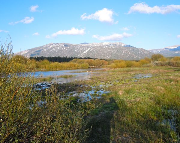
Upper Truckee River flows into the usually dry area of Cove East. Photos/Kathryn Reed

Upper Truckee River flows into the usually dry Cove East. Photos/Kathryn Reed

Sun will return on Thursday. The Memorial Day weekend is expected to have more sun than clouds. But don’t expect it to be super warm. Highs will be in the low-50s over the weekend and in the 30s overnight.

And it’s going to be windy.

Best places to be out and about on foot or bike will be close to the lake because of all the snow on higher trails.

Cove East is a good bet for an easy walk. Osprey and a bald eagle were seen flying around at this South Lake Tahoe location off Venice Drive on Monday.

The Upper Truckee River has breached its bank and is flooding into the meadow on the Cove East side.

A branch of Trout Creek is now entering into the river before reaching Lake Tahoe.

With this being National Boating Safety week through May 27, it comes with the added reminder that anyone thinking about going out on any body of water should be aware rivers are running fast, are icy cold and a place where life jackets should be worn.

– Kathryn Reed

ngg_shortcode_0_placeholder (Click on photos to enlarge.)