USFS expands offerings at Lake Tahoe recreation sites

By Kathryn Reed

Hunger pangs in the outdoors are never a good thing, but especially when the cooler is empty or one was never packed.

Tahoe Treats, a division of California Land Management, is operating nine concessions throughout the Lake Tahoe Basin for the U.S. Forest Service.

“The limit is when you change the character of the National Forest,” Don Lane, UFSF recreation forester, said as to what will be offered. “We think there is so much demand in the basin for these kinds of little amenities.”
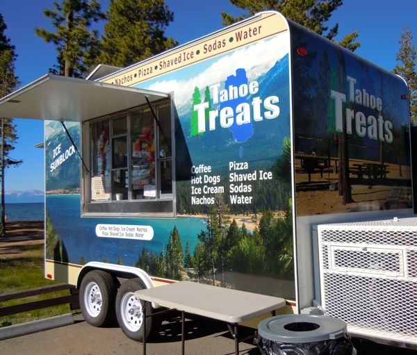
Tahoe Treats trailer at Pope Beach is steps from the sand. Photo/Kathryn Reed

Tahoe Treats trailer at Pope Beach is steps from the sand. Photo/Kathryn Reed

Lane said it’s a careful balance between giving people what they want and not overdeveloping recreation sites, even if the structures are temporary.

“We want to make sure when people go (to the beaches) with their families that they don’t have an overwhelming sense of commercialism,” Lane said.

Getting into the powerboat or personal watercraft business is not something Lane foresees happening; instead, letting the marinas around the lake handle that aspect of recreation.

Larry Chapman has his Tahoe Treats trailers at Pope Beach and Inspiration Point on the South Shore. He’s working on getting one in at Nevada Beach, but is having to muddle through red taped because the state doesn’t allow food trailers for extended periods of time. The plan is for it to be operating in mid-August.

Pizza is what people are ordering most often, though nachos are a big seller, too, Chapman said.

For people wanting to cool down, an array of drinks is available. So are ice cream bars and shaved ice.

One thing the Inspiration Point cart has that the other doesn’t is chili cheese dogs because it has warmers inside. And with no other food options between Camp Richardson and Tahoma, this cart can often have a line in the parking lot.

Because it took so long for summer to arrive in Lake Tahoe, workers were selling coffee, hot chocolate and tea at the start of the season.

While these are called carts, they are really trailers that hook up to the back of a vehicle.

Besides food offerings that have cropped up in the last couple years and that are expanding, kayak rentals are another convenience on Forest Service beaches.

Chapman is having Steve Lannoy with Kayak Tahoe operate the water sport concessionaire. Rentals are available at Pope, Baldwin and Nevada beaches.

Lannoy pays Chapman a fee and Chapman pays the Forest Service a percentage of his sales.

Lane said it’s easier to hire a concessionaire to operate facilities because they have the expertise as well as the manpower.

California Land Management has been working in the basin since 1985. The company has been running the Forest Service owned campsite at Fallen Leaf Lake for years. They also run the William Kent Campground in Tahoe City and Meeks Bay on the West Shore for the Forest Service.

Mountain bike trail design work in South Lake

Hilride will be back in South Lake Tahoe on July 24 to present their preliminary design drawings for lower Corral Trail.

They have taken the ideas generated during last month’s all-day session and put them down on paper.

The day starts at 9am at the U.S. Forest Service office on College Drive to review the plans and view photos and video from the June site visit. Following that, the group will convene at Corral Trail to discuss how the plans will look on the ground and start to flag out features and alignments.

This is an opportunity for mountain bikers to have a say on the design of trails in Tahoe.


Money available for residents with erosion control issues

The Truckee River Watershed Council’s River Friendly Landscaping Program is seeking to restore residential properties with significant erosion problems near rivers and streams in Truckee. The River-Friendly Landscaping program will award three single-family residences with $5,000 rebates and one multi-family residential property with $10,000 to reimburse homeowners for completed river-friendly landscaping.

The Truckee River Watershed Council and the Sierra Nevada Alliance launched the River Friendly Landscaping Program in 2010 to counteract the harmful runoff from residential homes. Funded by grants from the State Water Resources Control Board, the program aims to implement erosion-control and landscaping measures on residential properties that reduce pollution to the river and create sustainable landscapes.

Winners will also receive a custom landscape evaluation and site plan to help determine the needs of the property. Awards will reimburse materials and labor paid for by homeowners. River-friendly features can include native plants and flowers, retaining wall structures, gravel and mulch among a multitude of other river-friendly landscape features.

To be eligible applicants must own a home in the Truckee River watershed area and there should be significant erosion and/or storm water issues on the property. Applications are due Sept. 15 and winners will be announced Oct. 20.

For more information and to obtain an application, contact Reyna at reyna@sierranevadaalliance.org or (530) 542.4546, ext. 317.


Scramble to top of Twin Peaks provides great views

By Kathryn Reed

Summiting several of the well-known peaks in and around the Lake Tahoe Basin can give a hiker the feeling of being on top of the world. Same with Twin Peaks – just without the time commitment or exertion of a Tallac or Freel.

For those who live near this South Shore outdoor area, it’s a hike that can be done after work this time of year because there is enough light.

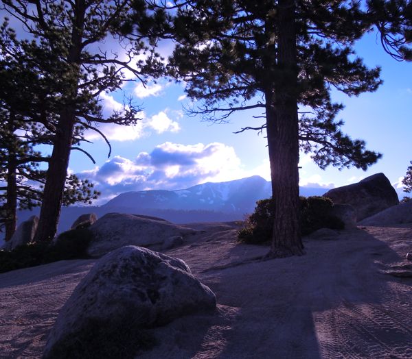
Mount Tallac from Twin Peaks. Photos/Kathryn Reed

Mount Tallac from Twin Peaks. Photos/Kathryn Reed

Twin Peaks is aptly named because it’s two peaks in one. And rumor has it those peaks are named after a particular woman who lived in South Lake Tahoe.

What makes it fun is that it’s a playground for different users. The easier of two four-wheel drive routes looks a bit gnarly this year, with a deep rut that doesn’t seem like a novice would want to attempt it. In the winter it’s a great place to snowshoe. In the summer, it’s a great hike.

Reaching the first peak, we scramble up the granite rocks to get the best view. Storm clouds are moving in last Wednesday. It doesn’t look like summer. Luckily, they were only threatening and nothing became of them.

Mount Tallac is to the left, but the sun angle makes it difficult to make out the cross. To the right is Lake Tahoe. To Tallac’s left is a waterfall in the distance coming out of the mountains – water that isn’t usually there. Snow is still visible in the higher elevations.

Behind us is the second peak with the tower on it to warn aircraft. We start on a distinct path toward it, but lose it pretty quickly. Bushwhacking is the norm for us on this hike. No worries about a trickle of blood here and there.

Close to the top Capone, his master and another guy greet us. They have built a hut of sorts they say they are spending the one night in. It looks cold.

From their perch they can see the multi-million dollar planes parked at Lake Tahoe Airport for the celebrity golf tournament.

We don’t stay long. The wind is whipping and the light fading.

Getting there:

From the Y in South Lake Tahoe, continue on Lake Tahoe Boulevard. Turn left on Sawmill Road. Park immediately in the lot to the left.

I start off a neighborhood street, but I’m not going to be responsible for cluttering up a residential neighborhood.

ngg_shortcode_0_placeholder (Click on photos to enlarge.)


Aquatic invasive species meeting in Truckee

The Truckee Regional Aquatic Invasive Species Prevention Program and the Tahoe Resource Conservation District ) invite the public to a meeting July 28 from 5:30-6:30pm to learn about aquatic invasive species prevention and get involved with future program development.

AIS pose a real and continuous environmental and economic threat to the Truckee region and its watershed. Prevention efforts are being aimed at halting the introduction of harmful aquatic species, as well as properly educating the public on the tangible threats AIS are posing to the Truckee area.

Brief presentations will focus on aquatic invasive species prevention and control efforts in the Truckee River Watershed. Program representatives will cover an analysis of the risks posed by AIS threatening the Truckee area, a history of AIS in the Truckee region, efforts which have been undertaken to address the spread of AIS in the Truckee area, as well as additional prevention programs in California and throughout the nation.

A public input segment will follow where citizens may emphasize where they would like to see prevention efforts focused.

The meeting is a Truckee Donner Public Utility District office, 11570 Donner Pass Road, Truckee. Park on the street.


First bi-state park in U.S. ready for hikers, bikers, horses

By Kathryn Reed

STATELINE – Making sure there is enough water pressure to fight a fire had been holding up the opening of Van Sickle Bi-State Park. Not anymore. The park officially opens today.

Considering part of the 725-acre park encompasses some of the 673 acres charred in the 2002 Gondola Fire, adequate fire suppression capabilities are a big deal – as it is for any forested area.

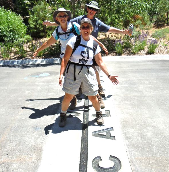
Sue, Brenda and Roni straddle the state line at Van Sickle Bi-State Park. Photos/Kathryn Reed

Sue, Brenda and Roni straddle the state line at Van Sickle Bi-State Park. Photos/Kathryn Reed

Even though the park was not officially open, people were still accessing the area that is walking distance from the main bed base on the South Shore at the state line.

It is destined to be one of the must-do hikes in the Lake Tahoe Basin because of the easy accessibility to some incredible views of the emerald water. The only thing that would make the scenery better is to obliterate some of the built environment, but that isn’t likely to happen any time soon.

An offshoot, though not yet marked, leads to a vista that captures the sprawling South Shore. Boats bob along in the water. Granite boulders invite one to lounge a while.

With views like this not far from the trail that starts from the upper parking area, it means for those who don’t want to or can’t hike far, they too, will get to enjoy the natural beauty.

Mount Tallac is the dominant feature besides the lake. With so much snow still on the mountaintops, it’s easy to pick out other peaks across the lake like Rubicon.

Massive sugar pines dangle like earrings from trees.

Hiking farther, the trail cuts through part of the 9-year-old burn area – a fire started from a reckless smoker who tossed a cigarette butt out the Heavenly Gondola.

Wildflowers, while not in abundance, are scattered on both sides of the trail.

Initially Van Sickle was supposed to be run by the parks systems in both states. The entrance sign makes it obvious that is not happening. Nevada Division of State Parks and California Tahoe Conservancy are recognized as the operators. This is the only park in the country to cover two states.

California State Parks is in such dire financial straits, what with 70 of 208 parks slated for closure, money for a new one was not to be found.

One advantage of California State Parks not being involved is that dogs are allowed on leash.

Work on the trail that connects to the Tahoe Rim Trail is ongoing, with volunteer crews out in force on Tuesdays and Saturdays.

“As for finishing the trail connector, we are hoping to finish it this year,” Mary Bennington, TRTA executive director, told Lake Tahoe News.

If it weren’t for her nonprofit organization, the park would not open at all this summer.

A couple small signs say the trail is not open beyond the waterfall. Nothing at the waterfall says stop, but the trail clearly deteriorates about a half mile farther. As Brenda said, it looks like someone dragged a pick behind her to designate where the trail should be built.

This park was a dream of the late Jack Van Sickle who donated more than two-thirds of the land for the park. His old barn sits in the day use area, as do smaller buildings.

Besides hikers, the park is open to equestrians and mountain bikers. The gate will be open when snow isn’t on the ground; and then from dawn to dusk.

Getting there:

From South Lake Tahoe heading east on Highway 50, turn right on Heavenly Village Way. The park entrance is on Montreal Avenue at Heavenly Village Way. The day use parking is up a short ways, with parking for trail access farther up the road.

A walking path off the driveway entrance is to the right. Foot access is also farther east off the Loop Road behind Harrah’s Lake Tahoe.

ngg_shortcode_1_placeholder (Click on photos to enlarge.)


Pool access limited during South Tahoe swim meet

Tahoe Swim Club is having its annual swim meet in South Lake Tahoe July 22-24.

This is a competitive meet for swimmers 18 years of age or younger.

To accommodate the event, the city’s pool will close at 1pm July 22 and the entire Recreation & Swim Complex will be closed to the public Saturday and Sunday.

For more information, call (530) 542.6056.


Backcountry patrollers train for wilderness rescues

More than 30 volunteers completed the annual training program to begin patrolling by bike, foot, or horseback on the backcountry trails around Lake Tahoe.

The training was conducted jointly by the Lake Tahoe Nevada State Park Backcountry Patrol and the Tahoe Rim Trail Association.

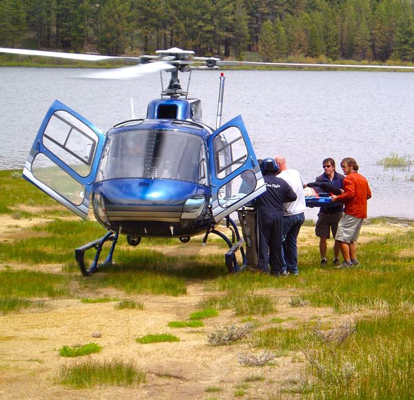
Volunteer backcountry patrollers practice loading a patient into a helicopter. Photo/Provided

Volunteer backcountry patrollers practice loading a patient into a helicopter. Photo/Provided

The training included multiple presentations on topics useful for patrol in the backcountry, including equestrian issues which included the opportunity for patrollers to safely handle and secure a loose horse; a bike repair session that covered basic repairs in a field environment; a medical scenario that included a CareFlight medical helicopter flying in and educating the group on helicopter safety and patient packaging; proper radio use, rapid medical assessments; and a presentation on “Verbal Judo”. Verbal Judo is described as the gentle art of persuasion. It will assist the patrollers in handling difficult people and gain voluntary compliance from errant park users.

Now in its 10th year, the patrol is part of the International Mountain Bicycling Association’s National Mountain Bike Patrol program. The 50-plus active patrolers are responsible for approximately 2,000 assists during the summer riding season. These are usually questions about the park history, trail recommendations, or riding etiquette; but the patrollers are also ready to fix a flat tire, bandage a wound, or assist with an emergency evacuation.

The patrol operates primarily out of Lake Tahoe Nevada State Park. The patrol also partners with the Tahoe Rim Trail Association to cover other areas.

For more information on the patrol, go online or email info@tahoebikepatrol.org.


USFS planning thinning project near Upper Echo Lakes

The U.S. Forest Service Lake Tahoe Basin Management Unit is seeking public input on the Upper Echo Lakes Hazardous Fuels Reduction project. The proposed action includes tree thinning and surface fuels reduction that is intended to reduce the risk of wildfire and improve firefighting effectiveness.

The project area is located on National Forest land within the wildland urban interface on approximately 100 acres at Upper Echo Lake in El Dorado County, with a portion in the Pyramid Roadless area.

Brief closures of areas adjacent to the Pacific Crest Trail are possible.

The proposed treatments would establish a defense zone around seasonal residence cabins and outbuildings. Cabin owners would retain the responsibility to maintain their defensible space improvements.

Fuel reduction work would consist of cutting and hand piling brush and conifer trees up to 16 inches in diameter. Vegetation would be cut by hand, with chainsaws or other hand tools. Piles would then be burned approximately one to three years later, once the fuels are dry and weather conditions allow for prescribed burning. Larger trees would be made available for fuelwood.

Work could begin as early as this fall and might take up to six years to complete, depending on funding and availability of burn days.

The public comment period ends on Aug. 15. Information is available at the Lake Tahoe Basin Management Unit Forest Supervisor’s office, 35 College Drive, South Lake Tahoe, or online.

For more information, contact Duncan Leao at (530) 543.2600 or email comments-pacificsouthwest-ltbmu@fs.fed.us using the subject: Upper Echo Lakes Fuel Reduction Project.


Whitebark pine tree faces threat of extinction

By Juliet Eilperin, Washington Post

The Fish and Wildlife Service determined Monday that whitebark pine, a tree found atop mountains across the American West, faces an “imminent” risk of extinction because of factors including climate change.

The decision is significant because it marks the first time the federal government has identified climate change as one of the driving factors for why a broad-ranging tree species could disappear. The Canadian government has already declared whitebark pine to be endangered throughout its entire range; a recent study found that 80 percent of whitebark pine forests in the Greater Yellowstone ecosystem are dead or dying.

The Natural Resources Defense Council asked the Fish and Wildlife Service to place the tree on the endangered species list. In its determination, the agency said that it found a listing was “warranted but precluded,” meaning the pine deserved federal protection but the government could not afford it.

The whitebark pine will remain a candidate under the Endangered Species Act and will come under review annually.

An invasive disease, white pine blister rust, along with insects such as mountain pine beetle, has infiltrated the historically colder altitudes where whitebark pines thrive. Fish and Wildlife Service biologist Amy Nicholas said these factors, along with fire patterns and global warming more broadly, are undermining the tree’s viability.

Read the whole story