Boys & Girls Club part of Paddlefest in South Tahoe

Members of the Boys & Girls Club Marching Beat Brigade will be on hand June 20 to help kick off the 2012 Paddlefest and other ceremonies commemorating the opening of Lakeview Commons.

The drummers will perform at 5pm with Liz Broscoe, South Lake Tahoe professional drummer.

Immediately following the performance, Broscoe will lead a drumming circle. The public is invited to attend and bring their drums.

Paddlefest is celebrating its fifth year with a special project: The World Tribal Canoe Project. The project is being developed by the Cultural Conservancy, a nonprofit organization based in San Francisco. The vision is an intercultural, multitribal collaborative venture to support the renewal of indigenous watercraft traditions of the Pacific, starting in California.

Paddlefest will be celebrated June 23-24 at El Dorado Beach with a variety of activities and booths celebrating paddling in South Lake Tahoe. For more information about Paddlefest, contact John Dayberry at nativeelementsoftahoe@gmail.com.


Douglas Count SAR looking for members

Douglas County Search and Rescue will soon have a training academy, and the team is looking for energetic men and women to join the organization.

DCSAR is a volunteer unit within the Douglas County Sheriff’s Office. DCSAR responds to assistance calls for lost or injured persons in the mountains, desert, backcountry, and waterways of Douglas and surrounding counties. DCSAR also provides emergency assistance during natural disasters and large public safety emergencies.

Last year, DCSAR responded to more than 50 missions in Douglas and surrounding counties. The team responds to calls 24-hours a day, 365 days a year, but no single member is expected to respond to every event. Members are, however, expected to attend regular training sessions in order to develop and maintain effective skills.

Anyone who wants to help his/her community in times of emergency should consider applying to the DCSAR team. Outdoor and basic medical experience is helpful, but not required. Anyone over 18 years old that is physically fit and has a positive attitude will be considered for inclusion on the team.

Academy and in-service training is provided to ensure all members are knowledgeable and proficient in performing their duties.

Applications may be obtained online and must be submitted by July 1.

For more information, contact John Soderman at (775) 720.6260.


Lake Tahoe to host Ironman triathlon

Ironman is returning to Lake Tahoe next year. It used to be a mainstay on the South Shore.

This time is will be the North Shore hosting the event on Sept. 22, 2013.

California has not had the triathlon since 2001.

“We estimate the total economic impact to the region to be approximately $8 million to $15 million over the course of the event,” Andy Chapman with the North Lake Tahoe Chamber/CVB/Resort Association, said in a press release.

More than 2,500 athletes are expected.

Ironman Lake Tahoe will start with a two-loop, 2.4-mile swim at Kings Beach.

Then its a two-loop, 112-mile bike course from the lake into Tahoe City, before following the Truckee River past Squaw Valley and into Truckee.

From there, the course turns south back toward Lake Tahoe, has a short loop in Martis Camp, continues past Northstar and climbs to Brockway Summit. After a decent back down to Kings Beach, athletes will complete a second loop, and then a final flat 17 miles to finish the bike course at Squaw Valley.

Runners will proceed along the Truckee River bike path into Tahoe City, and continue south along the shores of Lake Tahoe to a turnaround in Homewood.

Register online.


Completion of mile-long segment key to Tahoe City trails

After 25 years, the Tahoe City Lakeside Trail will be completed on June 21. The trail is a parkway, winding through public and private properties to provide the “missing link” in the largest trail network at Lake Tahoe.

The existing 19-mile trail system was missing this key one mile segment through Tahoe City, forcing hundreds of thousands of trail users onto the state highway through the town.

For more information about the North Shore trail system, read this November 2011 Lake Tahoe News article.

On June 21, TCPUD, Jake’s on the Lake, Auerbach Engineering, and Landesign will host an official dedication at 2pm at Jake’s on the Lake, located in the Boatworks Mall.

On June 24, the Lakeside Trail festivities continue with a “Let’s Get Linked” celebration at 1pm. A human link one-mile long with more than 1,000 people will be created and captured through video and aerial photography. A free concert on the beach concludes the weekend.


Annual South Crossing sailboat race on June 23

Lake Tahoe Windjammer’s presents the Southern Crossing, the group’s premier race, on June 23.

This approximately 25-mile sailboat race across the southern part of Lake Tahoe is open to all monohulls outfitted with the required safety equipment.

Registration is required.

Go online for the Notice of Race and application.


STPUD changing how water is distributed in Alpine County

By Kathryn Reed

WOODFORDS – Mark Twain was ahead of his time in so many ways, but as it relates to today, his quote, “Whiskey is for drinking; water is for fighting” may be the most important.

To avoid future fights over the clear liquid, the South Tahoe Public Utility District is being innovative in its approach to trying to stay ahead of the curve, while following the state and federal regulations it must comply with.

The Porter Cologne Act of the 1960s mandates all treated sewage and wastewater be exported out of the Lake Tahoe Basin no matter how clean it is. Some say this water from the South Tahoe PUD is better than what comes out of spigots in San Diego that people are drinking every day.

Harvey Place Reservoir in Alpine County is where treated wastewater from South Tahoe Public Utility District is stored. Photos/Kathryn Reed

And while district officials thought one day treated wastewater would be able to be used for irrigation in the basin, that day has not come nor is it likely to happen in the foreseeable future.

Considering recyclable water in Palm Springs sells for $3,000 an acre-foot, this stuff is valuable.

And the district wants to tap into it. For years it has been giving away 2,000 acre-feet of treated water to farmers in Alpine County. It’s been a mutually beneficial arrangement with farmers getting water for free and the district able to unload water for free.

But things are likely going to change when the current five-year agreement expires in 2015. That irrigation water for farmers in the Diamond and Ward valleys may go from free to fee.

(Current law prohibits treated California water from being used in Nevada, but the district is working to change those rules because Silver State farmers are interested in using this water.)

The future for STPUD

This summer begins the first of three phases of a project that will ultimately allow South Tahoe PUD the ability to generate power to run the irrigation system on the land it owns in the Diamond Valley as well as eventually sell power back onto the grid.

“Water is more and more valuable,” South Tahoe Public Utility District spokesman Dennis Cocking said last week while giving Lake Tahoe News a tour of its ranch in the Diamond Valley as well as the farms that benefit from the South Shore’s treated wastewater. “Water is no longer cheap and plentiful.”

The utility district bought the old Heise Ranch seven years ago after seeing the writing on the wall that farmers were starting to divvy up their land and therefore there may not be a place for this treated water. Laws require the treated water be sprayed on 100-acre parcels or larger.

Hal Bird with the district is in large part responsible for having the vision for the district to purchase the land and get on the road of being less dependent on others. The goal is self-sufficiency. He is also behind the improvements to make this land function at its highest level.

The original farmhouse is being restored and will one day be his office.

Most of the roads on the farm are dirt or gravel. It looks much like a working ranch. There is no evidence this land belongs to a water-sewer district and not to a bona fide farmer.

Besides giving water to farmers, for Alpine County to say OK to the STPUD-farmers’ agreement, the district had to make other concessions – like creating a fresh water fishery at Indian Creek Reservoir, stocking it every year with 15,000 pounds of trout and other commitments.

Had it not been for the federal mandate to pump the water away from Lake Tahoe, STPUD ratepayers would not be funding these improvements to Alpine County. Plus, 38.9 percent of each STPUD sewer bill goes to meet the demands of the Porter Cologne Act.

Alpine County residents weren’t thrilled at first with the idea of taking Tahoe’s wastewater. “We don’t want Tahoe’s crap” were common bumper stickers.

Now, though, the relationship between the county and STPUD is amicable.

Before the hydropower project truly gets under way the Army Corps of Engineers must sign off on the old Heise property not being a wetlands. That is expected in the next year. The land is drying out now – proof it is not a natural wetlands.

The pipes are being put in this summer. Inside them will be turbines that generate power. The in-conduit line generates the hydropower, Cocking explains.

“It’s a great way to get our feet wet in hydropower,” he said.

California keeps mandating power companies acquire more and more power from renewable sources. What South Tahoe PUD generates could help Liberty Energy fulfill this mandate.

Power from this project may be generated in 2014.

(In large part the 5 percent sewer rate the board approved in May that will take effect July 1 is paying for this project by being the money needed to pay back a low interest loan the district has secured from the state.)

Along the lines being installed will be three pivot irrigation systems that will allow for some of the acreage to be irrigated. The alfalfa could be sold or used as pasture land for cattle. Even now some of the district’s land is filled with cows munching away on the grasses or just lounging in this fertile valley – looking like they are sunbathing in this idyllic spot of the Sierra.

Transporting wastewater

The export line leading from the plant in the middle of South Lake Tahoe goes into Meyers, then along Highway 89 over Luther Pass, down to Diamond Valley where it comes out into a creek before going into the Harvey Place Reservoir. This effluent travels 26 miles.

The late Hubert Brons – a farmer, Alpine County supervisor, and Lahontan Water Quality Control board member – came up with the idea of the reservoir as a holding pen of sorts for water for farmers.

Devices were created so the treated water from STPUD did and still does not flow back into the Carson River – a main source of water for farmers.

As Cocking said, one would think with 5 million gallons a day of water coming out of the pipes, it would be a turbulent affair. Instead it looks like a good flowing mountain stream. And it looks like any other stream – like fresh water that one could use to fill her water bottle with.

The export line started working April 1, 1968. A lot of leaks sprung in the 1980s, necessitating most of the portions within the basin to be replaced in the 1990s. No longer does it go through Grass Lake, but instead skirts this area near the top of Luther Pass.

Grass Lake is one of a handful of identified peatlands areas in the Sierra, with another being the Sagehen Valley near Truckee.

Getting the wastewater pipeline out of this marshy area was of environmental significance.

In the 1990s, Tim Leslie, who at time represented the Tahoe area in the California state Senate, helped STPUD secure a variance to the Porter Cologne Act that allowed for six fire hydrants to be put in along Grass Lake Road that could be tapped in the event of a catastrophic fire. Lake Valley and U.S. Forest Service fire crews have access to those hydrants.

At the end of that road is the Luther Pass Pump Station where two huge tanks sit empty – and ideally always would. But just in case power and all back up power fails the 400,000 gallons intended for the other side of the hill would flow back into the tanks. This is designed to prevent a spill that would contaminate the Upper Truckee River as well as nearby land.

Inside the pump house is the equipment needed to get the effluent over the pass. This water is going up 1,200 vertical feet in six miles.

From Harvey Place Reservoir the water goes out the Diamond Ditch, which if one looks closely enough can be seen along the hillside. It then flows into the Diamond and Ward valleys for farmers to divert as needed.

ngg_shortcode_0_placeholder (Click on photos to enlarge.)


TRTA plans slew of hikes in July

With the start of the summer hiking season upon us, Tahoe’s peaks, wildflowers and vistas are beginning to beckon. Enjoy the wonders of the Tahoe Rim Trail with a free guided hikes in July.

These hikes are great for all abilities (shorter hikes are most appropriate for kids).

Advanced online registration is necessary.

July 6 – Van Sickle Family Friday Hike (2.2 miles) – The Tahoe Institute for Natural Science and the Tahoe Rim Trail Association are sponsoring this fun, family friendly interpretive hike each Friday in July. Participants will enjoy interesting facts about the history, flora and fauna of Van Sickle Bi-State Park and Tahoe. This is the perfect hike to take your family out on.

July 6 – Tahoe Mountain Sports Leave No Trace Sunset Family Hike (3 miles) – Tahoe Mountain Sports, the Leave No Trace Center for Ethics and the Tahoe Rim Trail Association are teaming up for a fun and educational hike that will include interactive Leave No Trace activities, night hike games and prizes for the entire family. Tahoe Mountain Sports will also provide a variety of headlamps to demo. Bring dinner for a sunset picnic on a ridge overlooking lovely Lake Tahoe.

July 13 – Van Sickle Family Friday Hike (2.2 miles) – The Tahoe Institute for Natural Science and the Tahoe Rim Trail Association are sponsoring this fun, family friendly interpretive hike each Friday in July. Participants will enjoy interesting facts about the history, flora and fauna of Van Sickle State Park and Tahoe. This is the perfect hike to take your family out on.

July 17 – Hawley Grade History Hike (6 miles) – Join us for a journey into the past as we hike a portion of the original trans-Sierra emigrant route and Pony Express trail through the Sierra. Learn a little of the history of the early settlers as we hike from the Tahoe Valley floor near Meyers and climb to the junction with the Tahoe Rim Trail just past Echo Pass.

July 20 – Van Sickle Family Friday Hike (2.2 miles) – The Tahoe Institute for Natural Science and the Tahoe Rim Trail Association are sponsoring this fun, family friendly interpretive hike each Friday in July. Participants will enjoy interesting facts about the history, flora and fauna of Van Sickle Bi-State Park and Tahoe. This is the perfect hike to take your family out on.

July 21 – Big Meadow to Echo Summit Backpack (about 8 miles/day) – Complete a beautiful segment of the TRT on this overnight backpack trip led by experienced TRTA guides. Beginning at Big Meadow trailhead, this hike will follow a scenic journey through wildflower covered meadows and past the shady shores of Round Lake. Participants will enjoy an overnight at Showers Lake. Hikers must be in very good physical shape and able to carry a backpack weighing 25-35 pounds, plus some group supplies.

July 27 – Van Sickle Family Friday Hike (2.2 miles) – The Tahoe Institute for Natural Science and the Tahoe Rim Trail Association are sponsoring this fun, family friendly interpretive hike each Friday in July. Participants will enjoy interesting facts about the history, flora and fauna of Van Sickle Bi-State Park and Tahoe. This is the perfect hike to take your family out on.

July 30 – PCT Travels the TRT (7 miles) – The Tahoe Rim Trail and the Pacific Crest Trail share more than 20 miles in Desolation Wilderness. Hiking on the PCT/TRT to Lake Aloha from the Upper Echo Lake water taxi, one will hike steadily on rocky terrain. The destination for this hike is the shore of Lake Aloha with its unique landscape of windblown trees and small flat, rock islands. We will enjoy snacks and lunch on the rocky shores of Lake Aloha before returning to the Echo Chalet. Fees: $20 cash for water taxi/person, as well as cash for ice cream and a cold drink at Echo Chalet after the hike.

For further details on what to bring and other dates and locations, visit the Tahoe Rim Trail Association website.


Landscaping becomes a challenge as Mother Nature changes

By Linda Fine Conaboy

Nearly five years ago as I drove my SUV from Reno to South Lake Tahoe to cover the aftermath of the Angora Fire for a Reno magazine, the farthest thing from my mind was the vegetation.
Angora Fire -- 5 years later

My photographer and I were assigned to interview residents and bring back a firsthand report on the devastation that we had only heard or read about in Reno.

As we edged our car into the long line of returning evacuees, we accepted rubber gloves and masks from one of the many volunteers at one of the checkpoints, not knowing exactly how and if we would use them.

It didn’t take long before we realized the masks were important gear as we entered what looked very much like what I expect a war zone may look, including the shell-shocked expressions on many of the faces of the people inspecting their once pristine property.

Smoke streamed lazily upward as if it were escaping from unseen vents drilled into Mother Earth, making the air unpleasant enough that we decided to wear the masks, like many of the returnees.
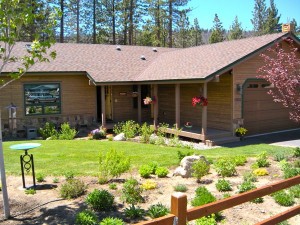
Houses in the Angora burn area were featured on a 2010 home tour. Photos/LTN

Some still-smoking trees stood but no underbrush was visible. In the place of the once heavily forested and landscaped yards were the bodies of non-recognizable cars resting on their frames along with melted bicycles and shards of glass and pottery strewn about.

Now, though, the tables have turned and because of the grit and tenacity of the returned residents, houses have popped up, albeit with little or no visible vegetation. Trees are widely spaced, many with scarred, blackened burn marks snaking up the tree meeting greenery about two-thirds of the way up.

The houses stand naked against the landscape where once grew a lush, mountain forest, where the trees would act as shields and wind screens protecting the privacy of those who live there.

According to Rita Mustatia, silviculturist (a person who looks after trees in the forest) with the U.S. Forest Service, the expression devastation is a misnomer. “I would use the word devastating in reference to the homes that were lost and lives that were changed because of the fire, but not to the forest itself,” she said.

“Fire in the forest is a natural thing and depending on factors such as location, climate, forest type, fire or some other disturbance, [fire] is needed for vegetation, including trees, to exist as part of a healthy functioning ecosystem,” Mustatia told Lake Tahoe News. “Disturbances such as fire eliminate competition between trees by reducing density and creating openings for regeneration.”

However, Mustatia said, most of the Angora Fire burned at high intensities leaving vast areas of little to no vegetation including trees. But about 40 percent of the fire burned at low to moderate intensities, she said, resulting in still living trees and some surviving vegetation.
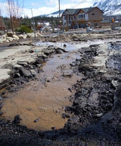
The high water table had roads in the burn area undriveable in 2011.

Some of these trees have subsequently died because of the damage caused during the fire as well as insects that have attacked them. But, Mustatia said, most of the survivor trees are healthy today.

“In some areas where the fire burned,” she continued, “it stayed on the ground as a surface fire resulting in mortality, mainly in smaller, shade-tolerant trees. The Jeffery pine, with its fire-adaptive traits, survived for the most part, resulting in a relatively healthy, post-fire condition. In other areas, where there was heavy fuel loading, the fire burned on the surface as well as through the crowns.”

Susie Kocher, natural resources advisor for the UC Extension Service, agreed with Mustatia. “Some forests are set up to burn every few years, like the Yellowstone fire in the 1980s.”

She said forests in the Lake Tahoe Basin are used to frequent, low intensity fire, but that has not been happening. “Now we have a high density of fuels and trees; consequently, we now have high intensity fires over a larger area killing a large number of trees.

“Part of it is that we’re good at putting out forest fires. But we kind of have a perfect storm in a way,” she said, attributing climate change and less snowpack to a longer fire season.

The question now for homeowners is, according to Kocher, do they want a forest or do they want a shrub field? “If you leave the forest that is located in a south-facing area on its own, not a lot of trees will come back soon — for about 60 years.”

Kocher stated the obvious: the Angora Fire killed a lot of trees in a large area. “There are no naturally, regrowing trees; there’s no seed source because there are no trees. If you want a forest, you need to replant or wait 60 or 70 years.”

She said areas without what she called “treatment” will see fire adaptive shrubs return; plants such as manzanita and white thorn. “And yes, the mushrooms are back, along with lupine and other wild flowers,” Kocher said. “After a wildfire, it’s a great time to collect mushrooms.”

But along with the good plants, invasive species like bull thistle make themselves at home too.

Homeowner Tony Colombo, who lives on Mount Olympia Circle, in a large, green, newly rebuilt Victorian, is angry about the fire for several reasons, not the least of which is his inability to re-establish his landscaping.

Colombo, and his wife, Tara Brennan, lost not only their home to the Angora Fire, but also all of the naturally occurring evergreens and vegetation that made their yard beautiful. “The soil was burned and contaminated,” he said. “And two-thirds of my new trees and shrubbery have died.”

Blaming the high water table in his area on his inability to grow anything except lawn, Colombo said the water on his property is so high in every month except during the summer, it is literally drowning his new trees.

Colombo’s high degree of frustration boils over as he talks.
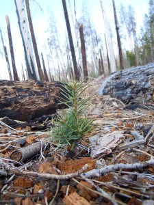
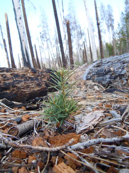
Natural regrowth in May 2012 near the ignition point of the Angora Fire.

“I’ve spent $45,000 of my own money for landscaping. Now we need a hydrologist out here. I don’t have the money for a professional landscaper, so we’re doing it ourselves. It seems nobody wants to address the water problem.

“The conundrum is now it’s really windy because there are no trees. When it’s hot, it’s barren, but in the winter, during rain and snow storms it floods. The water doesn’t sink into the ground.”

Enter John Fellowes, the owner of Aspen Hollow Landscape Nursery, who concurs. Yes, there is a high water table in some of the area where the Angora Fire burned. And, yes, now it’s windy and presents somewhat of a barren landscape.

“Myself and a few others have pointed out that this area is full of water. It sits on a glacial moraine — Angora Ridge. Springs come out of the mountain from the glaciers. The reason it never showed up in the past is because the lodge pole pine was as thick as hair on a dog’s back. There was a mix of about 80 percent lodge pole, with the rest being pine and a mix of incense cedar, white fir and Jeffery pine.”

Fellowes said he has concluded that in year’s past there were aspens and willows in the area, but over the years pines, the tree of choice by homeowners, have slowly replaced them. He said before the fire, these thick stands of pines made good use of the water coming out of the mountain, mitigating the high water problem.

Now that they’re gone, the water is back, playing havoc with some of the new gardens and especially the trees, although high water doesn’t seem to be a universal problem throughout the entire subdivision.

“My theory,” Fellowes said, “is the whole site, except for a few areas, should be replanted in a more riparian fashion. If willow and aspen had been planted [directly after the fire], they would have gotten started, made habitat and screens for people’s houses. Then, at a certain rate, the evergreens would have come back naturally.

“Unfortunately, the Forest Service planted most of what had already burned, probably conifers. If they’re dry, they won’t grow and if they’re wet, they get root rot and die. In the Gondola Fire (near Heavenly), they did the exact same thing and had 100 percent mortality — there was no resource to hand water [the new trees].”

Fellowes said he believes aspen and willows should have been planted where the natural water sites are, instead of the evergreens. He added that the Forest Service is now looking at using other species of trees.

Another problem at the Angora site is a lack of good fill dirt in which to grow healthy plants. To rid the area of hazardous material caused by the fire, nearly everything natural was removed from the burn sites.

“The contractors dug too deep and too wide. They were overly zealous. They took at least 50 percent of the topsoil and in many cases, 100 percent. Our problem is that fill dirt and good soil needs to be brought in; however, TRPA frowns on that.

“You couldn’t mimic an old natural site if you wanted to. Natural things like bitterbrush, manzanita and white thorn aren’t what people want. They don’t appreciate that they’re evergreen. You need everything to grow in the forest so you can trap the matter and assist the tree seedlings to grow.

“It’s extremely difficult to grow things now and I’m proud of the people who’ve persevered. Some have become apathetic and some have moved away. Some have been able to pull it off.”

Unlike Colombo, Lisa and Joe McAvoy were able to secure professional help to assist them with their landscaping issues. Fellowes was their man.

The McAvoys spent untold hours rebuilding their home, although not on their original lot. The result is an attractive craftsman style bungalow built and designed by them with a little help from their friends. But as the McAvoys said, the sweat equity was worth it; they knew what they were getting and got exactly what they wanted.

Yes, there is a high water table now, Joe McAvoy said, adding that before the fire, high water wasn’t what he worried about. But in order to alleviate the problem, they innovated as they went along.

“We have a dry creek bed that diverts a lot of water from our house,” he said. “We poured a curb around the foundation to divert water and waterproofed the foundation. We also have French drains.”

With Fellowes’ assistance, they augmented their soil and because of the steep street in front of their home, did a lot of water channeling. “We knew it was going to be a moonscape, so we worked hard to make it beautiful.”

So beautiful in fact, that the McAvoys’ home will be featured on the Lake Tahoe Historical Society’s annual garden tour to commemorate the fifth anniversary of the Angora Fire. The tour is July 29.


Nevada parks department has grant money available

The Nevada Division of State Parks has about $270,980 in federal funds for local park and recreation capital improvement and acquisition projects through the Land and Water Conservation Fund program.

All political subdivisions, including counties, incorporated cities, unincorporated towns, general improvement districts and tribal governments are potentially eligible for the 50-50 matching grants offered through the program.

Individual funding requests range between a minimum of $25,000 ($50,000 total project budget with a 50 percent match) and no maximum. However, applicants should be aware that the maximum amount is rarely awarded to any single recipient. Exceptions to the $25,000 minimum rule will be considered on a case-by-case basis for political subdivisions serving populations of less than 10,000. Local matches may exceed 50 percent, but the federal share cannot exceed 50 percent of the total project amount.

Application packages, including the application forms and grants manual, are available on State Parks’ website. The due date for grant applications is Aug. 31 by 5pm.


Baby birds learning to fly throughout Tahoe

By Cheryl Millham

Fledglings are falling out of trees like rain from a cloud. The early nesting is over and the birds are about 6 weeks old.

Fledglings can’t learn to fly in the nest. They have to come to the ground first. All of the body feathers are in place, but they have very short tails. Some fledglings are very smart and learn to fly in one day. However, for some it takes three days and even up to a week.

The parents will protect them (as much as they can) and feed them – while they are on the ground. “Our” responsibility is to let them stay with their family. Keep your dogs and cats away and under control.

Also, educate our children about the ways of wild birds.

If birds fledge in your yard, pick them up and set it outside of your fenced area. The mom and dad will find them and continue to care for them.

Remember, it is a false old wives tale that says, “If you touch a baby bird, the mom won’t take care of it!” The fact is birds cannot smell. The only bird which has the ability to smell is the turkey vulture.

More calls

I received another call from a man who wanted me to come and get a bear and take it out into the forest.

Well, for everyone’s information, the city of South Lake Tahoe is the only incorporated city within a national forest in all of the United States. So, we live in a very special place.

Lake Tahoe is a beautiful place and the early settlers decided to build houses. They put in roads and then more people moved in. Within a short time a small community was born. The wildlife that lived here (past tense), just moved over. Then the killing started. Humans were not happy in sharing their new home with the wildlife. And, it has not stopped.

It seems that whenever someone is inconvenienced by wildlife, their first thought is to have it killed or moved.

When Tom and I managed the boat marina at Camp Richardson (1976-82), one of the owners of a sailboat, who grew up in South Lake Tahoe, told us he remembered going to a government office and picking up some grain that was tinted red. It was poisoned grain to kill squirrels. People were complaining about too many squirrels, so – what do they do? – start killing them.

More and more people moved to Tahoe with more cats, more dogs, more houses and more roads. The wildlife just learned how to co-exist with humans. I’ll bet the wildlife wishes (or wished) the humans would learn how to co-exist with them. Either that or move back to where they came from.

So, remember — before there were houses, roads, dogs, cats and humans, the wildlife called Tahoe home.

Cheryl Millham is executive director of Lake Tahoe Wildlife Care on the outskirts of South Lake Tahoe.