Lake Tahoe area ski resorts count down to opening day

By Kathryn Reed

While this will be the first full season Kirkwood Mountain Resort has operated under the Vail Resorts flagship, it has been a mainstay in the Tahoe area for 40 years. Also celebrating its 40th year is the second newest Vail acquisition – Northstar.

But it’s Squaw Valley, Alpine Meadows and Sugar Bowl that are investing the most amount of money in infrastructure for the 2012-13 ski season.

Ski resort operators are doing snow dances in hopes no one comes to the slopes this year with open-toed footwear. Photo/LTN file

And that season has already begun. Squaw was open for a day in October as a fundraiser, while Boreal remains open on weekends.

Snowmaking guns at Northstar and Heavenly Mountain Resort were fired up in October.

All resorts are hoping that for this season the manmade stuff sets a base and gets the season going; unlike last year when snowmaking helped save the season. But even an epic, record snowfall winter like 2010-11 is not all that welcome because it makes getting to the resorts difficult and digging out challenging.

While forecasters look west, analyze computer models and study historical data to predict what the weather will be like this winter for the greater Lake Tahoe area, only time will reveal what this winter will be like. But if one is to look at local lore, most years when significant snowfall has dropped on Heavenly (like last month), that winter is above average when it comes to white stuff. Again, time will tell.

Here are few highlights at some Tahoe area resorts for this season:

Opening dates *:
Boreal – Open Fri-Sat-Sun
Mammoth – Nov. 8
Heavenly – Nov. 16
Northstar – Nov. 16
Squaw Valley – Nov. 21
Kirkwood – Nov. 21
Sugar Bowl – Nov. 22
Homewood – Thanksgiving-ish
Tahoe Donner – Thanksgiving-ish
Sierra-at-Tahoe – November-December
Alpine Meadows – Dec. 7
Diamond Peak – Early December
Mount Rose – Early December
Bear Valley – Early December
* All are subject to change.

Squaw

Big Blue Express, a high-speed six-pack chairlift, replaces High Camp chairlift. It starts where the base of the High Camp lift was, but goes farther – to the top of the ridge so it will be easier to access Shirley Lake, Solitude and Granite Chief chairlifts.

The Links double chairlift is out and in its place is Mountain Meadow, a triple chair.

The Park Pulley telecord, touted as a modern day tow lift, is designed to provide easy access to the Belmont terrain park and to eliminate traversing across the mountaintop meadow.

The resort is trying to catch up with others when it comes to snowmaking capabilities by putting in $3 million worth of upgrades. Some of that cash was also spent on groomers.

A Burton Learn to Ride program will be initiated.

Olympic Plaza Bar has been completely remodeled to the tune of $300,000.

New shops are also expected to open in the village.

While Squaw and Alpine have one owner as of fall 2011, the bulk of the money is being spent at the 1960 Winter Olympics venue. Combined, about $24 million in capital improvements have been made for this season at the two areas. This year’s investment follows the $15 million in base area and on-mountain improvements from last winter.

Called the Renaissance, the plan is to invest $70 million at Squaw and Alpine by winter 2015-16.

Alpine

With a vast improvement to snowmaking efficiency at Alpine, a mile-long terrain park will be built. Snow Park Technologies will be tasked with building Tahoe’s longest park.

Alpine will also operate a Burton Learn to Ride center.

The ticket office has been reconfigured with seven windows, including one to comply with the Americans with Disabilities Act.

Northstar

Additional glading was completed in the Promised Land ski pod over the summer.

Lack of snow last year prevented the launch of snowcat and backcountry tours on Sawtooth Ridge, so that is back on the agenda this season.

A Burton Riglet Park that introduces snowboarding to ages 3-6, like what Sierra-at-Tahoe started last season, will open at Northstar.

Sean White continues to call Northstar his training grounds. He will help design a 22-foot superpipe.

Tavern 6330’ opens in the Village at Northstar.

Dec. 22 is when the resort will celebrate its 40th birthday. White is expected to be on hand for the party.

Sugar Bowl

Sugar Bowl will be operating the country’s largest cross country ski area – Royal Gorge. The resorts are already linked by an “interconnect” trail that allows skiers to ski between the two. Plans are in the works to improve that route. Sugar Bowl also has plans to invest $500,000 in Royal Gorge this season.

The resort is partnering with Sierra Nevada Dog Drivers to return a sled dog race to the region after a 17-year hiatus. The Jack London Commemorative Sierra Sled Dog Derby will be at Royal Gorge on March 2-3.

In 2013, an academy that will train young skiers and snowboarders for high-level competition will be complete. This is part of the $50 million in improvements the resort has made in the last few years.

Rental gear is free for people participating in group lessons with a daily lift ticket.

Returning is the Rahlves Banzai Tour finale on March 16-17.

Kirkwood

Major capital improvements aren’t coming this season. Vail officials have not released a game plan or time line for upgrading their newest resort.

The Swatch Freeride World Tour makes its only U.S. stop at Kirkwood Feb. 27-March 3.

New this season is a four-day backcountry camp offered through Expedition: Kirkwood on Feb. 15-18.

Heavenly

Heavenly increased its snowmaking capabilities this summer with 10 energy-efficient Viking V2 snow guns on lower Stagecoach.

Unbuckle at Tamarack, the après ski party, is being touted as better than before. The Gunbarrel Grill is being called an “on-mountain man cave”.

The resort will host the U.S. Freestyle Championships on March 29-31.

Instructors in Heavenly’s Peak Performance Academy will work with skiers and snowboarders in an all-mountain clinic that will feature video analysis, high-end riding and off-piste tactics, while addressing personal goals. The two three-day clinics are Jan. 25-27 and Feb. 8-10 and one five-day clinic is March 4-8.

Sierra

Sierra-at-Tahoe this season will offer snowcat tours that will take skilled skiers and riders to the top of Huckleberry Canyon to access backcountry terrain. The Sierra Snowcat is also available for private tours by groups of five or more.

Sierra-at-Tahoe season passholders have the added benefit of skiing or riding for free at multiple mountains around the country. Unlimited season passes include 10 days at both Mountain High in Southern California and Stevens Pass Mountain Resort near Seattle. All Sierra season passholders can ski or ride Monarch Mountain in south-central Colorado for three days.




Coke protecting meadow near Carson Pass to off-set its water consumption

By Alex Breitler, Stockton Record

It is 170 miles from the headwaters of the Mokelumne River to the Bay Area plant where Coca-Cola makes millions of bottled beverages every year.

But the world’s largest soft drink company said it has a vested interest in that river.

And it has backed that up with a $200,000 check.

Coke recently paid that sum to help the U.S. Forest Service restore fragile meadows in the Indian Valley area, nine miles southwest of Carson Pass in the Mokelumne watershed. The restored meadows will soak up more snowmelt and release it slowly over the course of the dry season, rather than all at once during the spring.

Why does Coke care about the Mokelumne? That bottle in your fridge might well be courtesy of the river, which the East Bay Municipal Utility District diverts into aqueducts burrowing directly beneath Stockton and through the Delta.

Coke said the meadow restoration will offset about 90 percent of the water in the drinks produced at its San Leandro plant. That’s part of a bigger plan to be “water neutral” across Earth by 2020.

“It does cost money, but for us we consider it an investment into our long-term sustainability,” said Jon Radtke, Coke’s water resource manager. “It’s a business decision for us. We need (the water), the whole community needs it.”

The company has been accused at times of depleting water resources in the course of producing billions of drinks.

It takes 1.75 liters of water to produce a 1-liter beverage. The extra water is needed to sanitize the bottles, Radtke said.

Coke is not pledging to offset all of the water it uses, but rather all of the water that directly goes into its beverages. Radtke said the company is about 35 percent of the way to that goal.

Far from the plant, the meadows at Indian Valley had been degraded over the years from both human activities and natural conditions. The stream through the meadow had eroded, and the groundwater level had dropped.

Restoring the meadows will replenish about 80 million gallons of groundwater a year – or 300 million liters, in terms soft drink consumers can relate to.

That’s also roughly enough water for 250 families for one year.

The Pine Grove-based Foothill Conservancy, which advocates for the Mokelumne, had long supported the restoration of Indian Valley. Conservancy President Katherine Evatt said she was pleased the money came through, not only from Coke but also the National Fish and Wildlife Foundation.

“If people want to invest in watersheds, and I’m sure everyone has their own reason for doing so, but it’s all for the good as long as the environmental goals are good and sound,” Evatt said.


Asian clams being suffocated to protect Emerald Bay

By Kathryn Reed

Asian clams are expected to always be a reality in Lake Tahoe. But an $810,000, yearlong project is under way to keep them from taking over Emerald Bay.

With it estimated that 95 percent of the people who launch a boat at Lake Tahoe make their way to Emerald Bay, keeping that inlet as pristine as possible is not only good for the environment, but for tourism – aka the economy.

Brant Allen brings up a handful of Asian clams -- the ones he is helping get rid of at Emerald Bay. Photos/Kathryn Reed

Excretion from the clams creates algae blooms, which makes the nearshore, or beach area, unappealing to swim in, look at or paddle over. The bay has about 10 acres of nearshore.

These are not clams one eats – mostly because it would take too long to get a forkful. They are about 2 to 3 centimeters, with some 1-2 millimeters – like a grain of sand.

Another reason to eliminate the Asian clams is that they produce calcium – which Lake Tahoe doesn’t naturally have much of. And calcium is needed for quagga mussels to survive and thrive. To date, that aquatic invasive specie has not turned up in Tahoe. It is the critter that has devastated Lake Mead in Southern Nevada.

Allison Gamble with the Tahoe Environmental Research Center said it will be impossible to ever eradicate the clams from Lake Tahoe, but controlling them and eliminating them from key locations are the goals.

The earliest recording of this invasive clam at Tahoe was 2002, but it took six years for them to be a problem. A year later, 2009, was when the Aquatic Invasive Species Program rolled out. This included boat inspections, which look for Asian clams. Most likely the clams arrived via a boat’s bilge.

While scientists know the Asian clams are in Donner Lake, they were surprised when told by a photographer with the Reno Gazette-Journal that she found some in the Truckee River. There is no monitoring program on the river.

Clam control

On Oct. 25 a team of divers began covering 5 acres at the mouth of Emerald Bay with a biomass material made of shredded aspen that is then covered with a rubber mat. The purpose is to smoother the clams. This is all being done in about 15-feet of water, with 25 feet being about the deepest.

Looking over a boat it’s easy to see the black covering the sand. Crews should be done placing the mats by the end of November. During this time boats may still access Emerald Bay, but there could be a bit of a delay if divers are in the water.

Brant Allen with UC Davis is one of those divers. On Tuesday he described it as an “exhausting day of work.” The mats that are rolled out by two divers weigh 300 pounds on land and not much less under water.

It takes about 30 minutes to unroll each mat. Two hundred thirty-eight mats need to be placed on the lake bottom. The project also includes 25 tons of rebar that cover 10 miles, and 17,000 rivets.

The goal is to suffocate the clams by extinguishing their oxygen supply. Scientists have access points to check the site on what will likely be a monthly basis until all of the material is removed a year from now.

They live just under the sand. When shells are visible, it means the clam is dead.

Other points of interest

Steve Chilton with the U.S. Fish and Wildlife Service said, “AIS is the largest threat to the ecosystem.”

Most of the clams are on the south end of the lake. Emerald Bay is the farthest point north and west they have been found.

“The economic impact of Emerald Bay to Lake Tahoe and the region cannot be overstated,” Dan Shaw, environmental scientist with California State Parks said. The bay is state parks land.

About 1,000 boats a day come into the bay on peak summer days. Shaw told Lake Tahoe News a camera was set up this summer to record the speed of boats, but because so many come through the mouth it was impossible to gather that data.

To pay for the project, California Water Board allocated $458,220 and $352,000 came from the Southern Nevada Public Lands Management Act. The latter source of funding will be exhausted in 2014, so where money will come from for future projects is an unknown.

ngg_shortcode_0_placeholder (Click on photos to enlarge.)


Giants — World Champions!

Giants fans send a message during Game 2 in San Francisco. Photo/Kathryn Reed

San Francisco Giants — World Series champs!

They won Sunday night in the 10th inning — 4-3. It was a four-game sweep.


3 waterfalls tumble through scenic river canyon

By Kathryn Reed

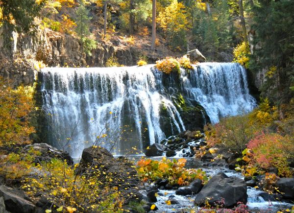
MCCLOUD – It’s October in a dry water year and we’re in search of waterfalls.

Wow!

The amount of water descending last weekend from the three falls along the McCloud River was thundering. I can’t even imagine what they would be like in the spring – especially in a normal snow-rain year.

The McCloud River offers three distinct waterfalls. This is Middle Falls. Photos/Kathryn Reed

According to the U.S. Forest Service, “The Upper McCloud River is spring-fed, not dammed, and flows steadily all year through a basalt canyon lined with forest of Douglas-fir, white fir, Pacific yew, ponderosa pine and incense-cedar.”

If it weren’t for the abundance of fall colors, just looking at and listening to the water it would have seemed like this were a different season. Each waterfall is spectacular in itself.

For a 3.8-mile round-trip hike, this is one of the best for scenery in such a short distance. Where else are three waterfalls in such close proximity?

Black oak, vine maple and Pacific dogwood brighten the forest with their yellow, pink and orange. While the color is not as vibrant as Tahoe has been this fall, the variety of foliage was a welcome change.

Sometimes the trail is like walking through a dense forest, while other times there’s an airiness with blue sky as the canopy.

Lava rock is in abundance.

This is a rather easy hike in the Shasta-Trinity National Forest that ascends 300 feet to a maximum elevation of 3,600 feet.

Heading back we get a glimpse of Mount Shasta.

Plenty of fly fishermen (and women) are casting lines in hopes of snagging a trout. Most are releasing their catches. It’s such a popular fishing hole that two vehicles from an Oregon outfitter are in the parking lot.

With temps routinely hitting the 90s in the summer, the swimming holes welcome those who want to cool off. People are also known to use the cliffs as an entry point into the river.

Even though overnight temps were freezing and this area got snow when Tahoe did last week, some of the campground spots were taken by RVs and tents.

The Forest Service acquired this land in 1932 from the McCloud River Lumber Company. Originally, it was the seasonal home of the Wintu Indians. The campground gets its name from T.B. Fowler who homesteaded in the late 1800s. He eventually built a hotel along the river that burned to the ground in the early 1900s.

Getting there:

McCloud is about an hour north of Redding.

From South Lake Tahoe, get onto Interstate 5. Then go toward McCloud on Highway 89 for 15 miles. Turn right at the Fowlers Campground sign. Park in the day parking and start walking.

It’s also possible to drive to each of the falls and walk just a short ways.

ngg_shortcode_1_placeholder (Click on photos to enlarge.)


Truckee Ranger District to begin prescribed burns

The Truckee Ranger District will begin fall prescribed burning in the Truckee area as weather permits. The timing of burning will depend on favorable weather conditions and may continue periodically until significant snow accumulates.

The prescribed burns will be implemented by fire management professionals.

Weather is the most critical factor in determining when a prescribed burn can begin. Temperature, humidity, fuel moisture, and wind conditions are monitored for the right burning conditions.

In addition to weather factors, wildlife needs, soil conditions, tree survival, sensitive plants, and fire suppression activities are all considered in the timing of prescribed burns.

A benefit of the prescribed burning will be reduced intensity of future wildland fires in the treated areas. These areas may also provide firefighters with safe locations to control wildfires in the future.

Some of these burns are located in more remote areas of the forest, while some are near communities. Within the Truckee Ranger District of the Tahoe National Forest, pile burning is planned along Alder Creek Road, near Tahoe Timber Trails, Henness Pass Road, Klondike Flat and Serene Lakes. Underburning is planned near Klondike Flat, on Sawtooth Ridge (south of Truckee, above Hwy 89 South), and near Stampede and Boca Reservoirs. Smoke will be visible in these areas.

Forest Service fuels management personnel work closely with the California Air Resources Board and the local air quality management districts to minimize smoke impacts to communities. Not all smoke can be avoided, however. At times smoke will settle into low areas and drainages during the evenings and last into the next morning until daytime heating increases air movement and smoke dispersal.

For more information on the fuel reduction efforts on the Truckee Ranger District, call (530) 587.3558.


Giants ready to feast on more Tiger

Madison Bumgarner throws the first pitch of Game 2 of the 2012 World Series on Oct. 25. Photo/Kathryn Reed

Game three of the World Series is today. The Giants are hoping to take a three-game lead over the Detroit Tigers.

Lake Tahoe News was at game two in San Francisco on Oct. 25.

Here are a few videos from that night:


Giants’ stolen base in Game 2 means free tacos for everyone

By Huffington Post

Angel Pagan has become a fan favorite in San Francisco. But with one clean swipe of second base, he may have won over America. At the very least, those in the country who love Taco Bell are now among his fans.

In eighth inning of the Giants’ 2-0 win in Game 2 of the World Series, Pagan got a great jump on Detroit reliever Drew Smyly’s first pitch to Pablo Sandoval. Catcher Gerald Laird fired a strike to second baseman Omar Infante but Pagan slid in ahead of the tag. By stealing second, he not only got himself into scoring postion but he triggered a World Series promotion by the fast food chain.

The “Steal A Base, Steal A Taco” promotion promised that we’d all be treated to something called a Doritos Loco Taco if any player stole a base in the World Series. According to MLB.com, you just need to turn up at participating Taco Bell on Oct. 30 between 2-6pm to get your free taco.

“Actually, bring it over here. I’m hungry right now. I just found out about it. I’m pretty happy, but I was just trying to play the game hard,” Pagan said after the game, via Big League Stew. “Trying to create a situation for us to score and then, after the game, they told me about it.”

First a three-homer game. Then free tacos for everyone. What’s going to happen in Game 3?


Tahoe Conservancy ready to restore Upper Truckee Marsh

By Kathryn Reed

While the Tahoe Keys subdivision will remain as is, the sensitive wetlands surrounding it could expand, sand dunes may return, the sailing lagoon that abuts the Cove East walking trail may be filled in and that trail rerouted, and the mouth of the Upper Truckee altered.

These are some of the proposals in the draft environmental documents that will be released by the end of the year for the Upper Truckee Marsh.

Four alternatives are being studied. The California Tahoe Conservancy owns this swath of land that borders the Tahoe Keys and Al Tahoe neighborhoods in South Lake Tahoe and goes from Highway 50 to Lake Tahoe. No preferred alternative has been selected, so all four will receive equal analysis.

It's possible this lagoon at the Tahoe Keys will be filled in. Photo/LTN file

“The purpose of the project is restoration, but we know it is well accessed so we had to do some level of public access,” explained Scott Carroll, project manager. “We just put different features in different alternatives so we could evaluate the impacts – from water quality to impacts on biological resources to parking – the array. In the end, when we develop a preferred alternative, what we do to the site will be guided by what access works in that type of setting.”

One option includes building a platform that would allow cyclists and walkers to get from one side of the meadow to the other. Other things being considered to make the area more people friendly include a fishing platform, signs and kiosks.

Most of the proposed changes are for the Cove East side of the marsh. It’s possible the mouth of the Upper Truckee River could be rebuilt or reduced. In the 1960s it was dredged and was the original access to the Keys.

The Conservancy acquired the 22 acres in a settlement agreement stemming from the Keys development. In 2002, a $10.5 million restoration project was completed that brought back the wetlands that run between the walking path at the end of Venice Drive and the river.

Three of the alternatives would fill in the sailing lagoon, which is to the left of the trail when walking toward the lake. Then the trail would head in that direction where boats come into the marina instead of along the river.

Restoring the Upper Truckee River is a large component of this project.

“We want to restore the historic and natural hydrology of the system as much as we can within the constraints we have,” Carroll told Lake Tahoe News. “(The) express purpose (is) enhancing the ecosystem of the area – from habitat for aquatic species and terrestrial, and species utilizing the riparian zone. We are trying to create a sustainable linked system.”

The other goal is improving the water quality that enters Lake Tahoe.

Three individuals own some of the land where the Conservancy would like to do work – Marjorie Springmeyer, Knox Johnson and Royce Dunlap. All have been approached, but no agreements are in place.

For the most part, little is proposed for Trout Creek, which runs through what was known as the Barton Meadow. Those 311 acres were purchased about 11 years ago for $10 million and is now referred to as the Upper Truckee Marsh. It is considered one of the most sensitive areas in the basin.

The bank of the creek near the highway is proposed to be fortified in each of the alternatives.

What this project will cost is unknown. And when it would begin is also undetermined. CTC employees expect a number of comments will be received during the 60-day comment period. The plan is for the Tahoe Regional Planning Agency’s Advisory Planning Commission and Governing Board to discuss the project in January. The final environmental impact report and environmental impact statement could take a year to prepare.

When the project begins, it’s possible it will be done in multiple phases depending on funding sources.


Slew of rescue missions keep El Dorado SAR volunteers, deputies busy

It has been a busy week for the El Dorado County Sheriff’s search and rescuer. Numerous backcountry visitors were caught off guard by the early season storm.

Approximately sixty 60 SAR volunteers, along with four deputies responded to 11 deployments between Oct. 19 and Oct. 24. Nine were in El Dorado County and two in Alpine County.

Events started Oct. 19 with the report of a sick hiker at the Lake of the Woods in Desolation Valley. A 17-year-old girl from Los Osos had been hiking in the Desolation Wilderness area with her 18-year-old girl friend when she acquired altitude sickness. SAR volunteers responded to the area and spent eight hours carrying the teenage girl out to safety.

On Oct. 20, SAR volunteers in South Lake Tahoe responded to an injured mountain biker in the Freel Peak area. The Berkeley man sustained a head injury and had to be carried out by SAR and Lake Valley fire personnel. He was transported to Barton Memorial Hospital. His present condition is unknown.

At approximately the same time SAR personnel responded to a report of two lost hikers on Mount Tallac. A CHP helicopter was utilized to locate the subjects and directed them back to a trail they could follow to get off the mountain. They were then able to find their way out without further assistance.

Also on Saturday, the sheriff’s Placerville office received a report that a 58-year-old hunter from Sacramento was missing as he had not returned to his camp as expected. He had been hunting in the South Fork Camp area of the Crystal Basin Recreation area. SAR was deployed along with the assistance of the U.S. Forest Service and a California Highway Patrol helicopter. After SAR personnel were deployed and initiated search efforts he found his way back to camp. He had a minor leg injury that was checked by SAR personnel, however he refused further medical treatment.

On Oct. 21, Alpine County requested mutual aid to search for a lost hunter. The missing subject was located while SAR volunteers were in route.

That night two girls, 12- and 13-years-old, were reported missing in the Wentworth Springs Campground area of Crystal Basin. While exploring near their campsite they became disoriented and did not return to camp as expected. SAR volunteers were dispatched to the area, however family members located the girls before the volunteers arrived.

Also on Sunday night, three fishermen from the Sacramento area were hiking in the Gerle Creek Reservoir area of Crystal Basin. When hiking back to their vehicle they had become separated and at about 4am on Monday two of the fishermen reported their friend missing. The temperature had dropped and it was snowing. SAR personnel responded to area and found the missing fisherman’s tracks in the snow. SAR personnel began following the tracks. The tracks were headed out of the area and eventually lead to a snow covered access road. SAR personnel continued to follow the individual eventually locating him at 8am. He was in good condition with no injuries.

While conducting the search for the missing fisherman SAR personnel were contacted by the wife of a hunter. She advised that her husband had called her and advised that he had rolled his Jeep on an unknown snow covered dirt road in the Crystal Basin area. SAR personnel began looking for the subject and located him near Granite Springs. SAR volunteers coordinated a medical response for the subject, that provided him treatment for minor injuries.

On Oct. 22, a report was received that a personal emergency response beacon had been activated for a 39-year-old Pleasant Hill man and his wife. Information was obtained that the couple were hiking in the Lake of the Woods area in the Desolation Wilderness.The activation of the emergency beacon indicated the couple were in the area of Echo Lakes. SAR personnel were dispatched to the area and located the couple in a cabin on Upper Echo Lake, where they had taken refuge from the ongoing winter storm. SAR personnel assisted the couple back to their vehicle.

Then on Oct. 23, SAR personnel responded to a mutual aid request to assist Alpine County in a search for two missing hunters. A 40-year-old Calaveras man and his 14-year-old nephew had been missing since Sunday. They were eventually found in the Bear Valley area on Tuesday. The man was alive suffering from severe hypothermia. Unfortunately, the boy had passed away.

That night, just before 10pm, deputies received a report of an overdue hiker in the Desolation Wilderness Area. The father of a 29-year-old male reported his son, and his son’s friend, had gone camping. His son (Nathan Sperring) hitchhiked to the Eagle Falls trailhead on Oct. 19. He planned to hike into Dick’s Lake, in the Desolation Wilderness. They had advised they would return to Tahoe City on Oct. 23. As of this time they have still not returned. SAR personnel have responded to the area and are currently conducting search operations. Because of the volume of SAR details the volunteers have been handling, the El Dorado County Sheriff’s Office requested mutual aid through the California Emergency Management Agency for this event. The U.S. Marine Corp Mountain Warfare Division has sent their Mountain Rescue Unit out of Mono County, to assist in the search.