Winter storm warning means rain turning to snow in Tahoe
A winter storm warning has been issued for Sunday until 4pm for the Lake Tahoe area.
The National Weather Service in Reno is calling for 4-8 inches of snow at lake level, 10-16 above 7,000 feet, and more than 2 feet above 8,000 feet.
The rain falling this morning will turn to snow in the afternoon.
Expect whiteout conditions on surface streets, but especially over the passes.
The California Department of Water Resources has a list of rain totals for various locations on its website.
A break in the weather is expected on Monday. For skiers and snowboarders, it could be an incredible powder day. Ski resorts throughout the greater Lake Tahoe area have been receiving snow at the upper elevations while rain soaked the lakefront.
But don’t put the rain gear away, but more of the wet stuff is expected to hit the Tahoe area on Tuesday and continue through Wednesday. The sun should pop out again on Thursday.
— Lake Tahoe News staff report
4 more companies want to cash-in on Tahoe’s crayfish
Four outfitters want permission from the Tahoe Regional Planning Agency to harvest crayfish from Lake Tahoe.
In July, the Tahoe Lobster Company run by Fred Jackson received permission from Nevada officials to begin pulling the nonnative species from the lake and selling them for consumption. This is the first commercial fishing operation on Lake Tahoe since the 1930s.
Besides something different to dine on, removing the crayfish helps improve the clarity of the lake. They are linked to algae blooms.
Scientists estimate there are between 200 million and 300 million of them swimming around Lake Tahoe.
The current applicants are: Tahoe Crayfish Co., Tahoe Crayfish Henrichsen, Tahoe Blue Crayfish Co., and High Sierra Ventures. Each applicant wants to operate one vessel that could ply the waters of both states.
A public hearing will be conducted before a hearing officer of the TRPA on Dec. 20 at 2pm, 128 Market St., Stateline. Applications are available to review by the public at the TRPA office. For more info, call Patrick Stone at (775) 589.5213.
— Lake Tahoe News staff report
Strong winds, more rain coming Saturday into Sunday
The following are unofficial observations from storm reporters to the National Weather Service in Reno for the current series of storms through 11am Dec. 1:
While there is a lull in the storms, the Saturday afternoon break will not be long-lived.
A powerful low-pressure system is on its way tonight and into Sunday. A high wind warning for the Lake Tahoe Basin has been issued until 10am Sunday.
The National Weather Service in Reno is calling for wave heights on Lake Tahoe to be between 4 and 7 feet. The winds out of the south will be 25-40 mph, with gusts of 65 mph. While some trees have toppled, they have missed structures. Gusts along the Sierra ridge could hit 140 mph.
Rain will return Saturday night and continue into Sunday.
Moderate flooding is expected along the Truckee River from Truckee to Sparks. Some bridges in Reno will be closed starting Sunday morning in preparation for the river hitting flood levels.
An evacuation center will open at 6am Sunday at the Administration Building of the Tahoe Truckee Unified School District at 11603 Donner Pass Road.
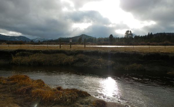
Upper Truckee River in South Lake Tahoe on Dec. 1. Photos/Kathryn Reed
The Upper Truckee River and Trout Creek on the South Shore were flowing at a fast clip on Saturday, but not at flood levels. The Upper Truckee, though, could be seen from Highway 50 in South Lake Tahoe, when looking east, flowing into the meadow.
Sand bags are available in South Lake Tahoe at the fire station near the Y and at Bijou Community Park. In Douglas County they are available at Topaz Community Center, Ruhenstroth Firehouse, across from the Gardnerville Ranchos Firehouse, Johnson Lane Firehouse, Genoa Firehouse, Jack’s Valley Firehouse and Zephyr Cove Firehouse. Sandbags are available at the Truckee Fire Protection District Station 92, 11479 Donner Pass Road. In Placer County, sand bags are available at: North Tahoe Fire Station 52, 288 North Shore Blvd., Kings Beach; Placer County Department of Public Works Corporation Yard, 2501 North Lake Blvd., Tahoe City; Old Squaw Valley Fire Station, 1810 Squaw Valley Road, Olympic Valley; Northstar Community Services District Corporation Yard, 50 Trimont Lane; and North Tahoe Fire Station 53, 5425 West Lake Blvd., Homewood.
— Kathryn Reed
ngg_shortcode_0_placeholder (Click on photos to enlarge.)
Vonn, Cook repeat 1-2 finish at Lake Louise
By USSA
The No. 1 speed team in the world — the U.S. Ski Team — put six athletes into the top 20 on Saturday at Lake Louise.
Superstar Lindsey Vonn came back from the brink of disaster to win her 55th career Audi FIS Alpine World Cup, matching the great Swiss Vreni Schneider for second in the all time wins list. Vonn, who was already 0.24 behind, went wide on a sweeping turn before the midway point of the course losing valuable time. But she nailed the bottom of the Lake Louise downhill to take a 0.52 second margin over teammate Stacey Cook and extend her win streak on the Canadian Rockies course to six.
It was Cook’s second career podium, matching the result of a day earlier.
Vonn will go for a sweep in Sunday’s super G.
Julia Mancuso (Squaw Valley) was ninth, Alice McKennis (Glenwood Springs, Colo.) 11th, Laurenne Ross (Bend, Ore.) 18th and Leanne Smith (North Conway, N.H.) 20th.
Vonn moved into fourth in the Audi FIS Alpine World Cup standings behind Slovenian Tina Maze, 347-210. Vonn and Cook are one-two in the downhill standings.
Cook, who is from Mammoth, had the added bonus of picking up her first two podiums with her family in attendance.
“I hope this is the tip of the iceberg for me. My coaches have told me that I’m like a fine wine – that I get better with age and it’s true,” Cook said. “I just hope the body holds out with the age.”
Ganong leads U.S. team with 16th finish in Beaver Creek
By USSA
BEAVER CREEK, Colo. — A record crowd packed the Audi Birds of Prey finish area Friday as Italian Christof Innerhofer took the win in the men’s downhill. Travis Ganong of Squaw Valley led the U.S. Ski Team in 16th.
“I pushed the line, I really charged. I wanted to do something big today,” Ganong said. “But I had some mistakes. I was pretty pumped up. But my skiing’s in a pretty good place and it will get better and better.”
It was the first downhill win for Innerhofer in four years as he upset favorite Aksel Lund Svindal of Norway who was second.
Marco Sullivan of Squaw Valley, who was on the podium in Lake Louise a week ago, was 18th.
Racers from across the world praised the Audi Birds of Prey course crew for building one of the best World Cup tracks in recent memory.
Cook second behind Vonn in downhill
By USSA
A still ailing Lindsey Vonn of Vail stormed to a 1.73 second downhill victory in foggy Lake Louise as teammate Stacey Cook from Mammoth was second to climb atop the first Audi FIS Alpine World Cup podium of her career.
The weather-plagued race was stopped multiple times as fog drifted in and out. It was the 54th victory of Vonn’s career and fifth straight in Lake Louise.
Julia Mancuso of Squaw Valley was eighth, Laurenne Ross 11th as the best in the world U.S. women’s downhill team placed four in the top 15.
“I’ve spent a lot of time on this hill over the years. It’s been a lot of perseverance, sticking it out, and it feels so good to finally get on the podium. I really shut my brain off today. I know I can ski with these girls,” Cook said. “I’ve been so close for so long, so today I decided it was time. I let my ability take over.”
Sugar Bowl not opening on Saturday because of storm
With several strong systems of extreme weather delivering mixed precipitation, high winds and fluctuating snow levels, Sugar Bowl announced this morning that the resort will be closed Dec. 1.
“These storms are actually great early-season base builders and it’s snowing pretty good up top,” resort operations director Scott Ferguson said in a statement. “But with strong winds impacting lift operations and mixed precipitation limiting visibility, and perhaps more importantly in the interest of maintaining the lower-level base we’ve already got, we’ve made the decision to close for this Saturday.”
Forecasters on edge as storms hit Tahoe, Reno
By Kathryn Reed
RENO – Extra personnel have been called in to analyze the vast amount of data flowing into the multitude of computers at the National Weather Service office in Reno.
This storm that is upon Northern California and Nevada is expected to be a doozie, with drenching rains that could cause flooding in the Lake Tahoe Basin, Truckee, Reno-Sparks, and points south on Highway 395.
Of most concern to forecasters is how high the Truckee River will rise in Truckee and Sparks. Rivers are expected to crest on Sunday. All tributaries into Lake Tahoe are also being watched, with the Upper Truckee River being the largest one.
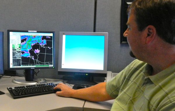
While it’s quiet inside the confines of the weather bureau on Thursday morning, plenty of work is going on. Each workstation contains several computers. Most have lots of color on the screens – an indication something other than sunshine is on the horizon.
One screen breaks down the predicted snowfall for the Sierra for the next seven days in six-hour increments.
Jon Mittelstadt, meteorologist in charge, points to the satellite data showing the “atmospheric river from Hawaii” that will bring the heavy rain to the region this weekend. “The satellite has a sensor for water vapor,” he explains.
It’s looking like after the brunt of the storm things will dry out for a few days before more moisture comes in late next week.
But the severity of this storm has Reno forecasters talking to FEMA, emergency management crews in California and Nevada, departments of transportation, law enforcement as well as hydrological partners.
A winter weather advisory is in affect above 7,500 feet for Friday from 4am to 4pm. Six to 12 inches could fall at that level. It’s expected to be heavy, wet snow – making driving even more precarious. A flood watch remains in effect from Saturday afternoon through Sunday morning for the Lake Tahoe Basin, eastern Alpine County and the Reno-Carson City-Minden area. A period of heavy rain with high snow levels will occur Saturday evening through Sunday. Rainfall amounts Saturday through Sunday morning of 3 to 5 inches are possible in the Lake Tahoe Basin, with isolated amounts up to 7 inches along Highway 89. Areas at greatest risk for flooding are small creeks and streams along and west of Highway 395 from Lassen County, south through the Reno-Tahoe-Carson City area and into northern Mono County. Mud and rockslides are possible in areas of steep terrain and near recent wildfire burn areas. — National Weather Service, Reno
Four television screens provide “situational awareness” for the team to keep track of various locales – from a loop of Caltrans cameras over Donner Summit to what is going on at Reno-Tahoe International Airport.
The Reno office, which is one of 124 throughout the United States, handles the forecasts along the crest of the Sierra, Tahoe, and all of Washoe County to the Oregon border, and then points south of Reno. Neighboring offices are in Sacramento, Medford, Ore., Hanford, Elko and Las Vegas.
The River Forecast Center in Sacramento handles all of the rivers.
Inexact science
It’s necessary to staff the weather office 24 hours a day, seven days a week because things are always changing. Predictions can be made based on what the data says, but Mother Nature has a mind of her own.
“If you get past five or six days, you can’t have confidence in the forecast,” Mittelstadt told Lake Tahoe News.
Mittelstadt knows weather guys get a bad rap when they say one thing and another occurs.
One problem with being in the West is no one is in the Pacific Ocean feeding data to those on shore about what the storms are like. Satellites help, but they can only do so much. Ship reports come in, but they don’t have data from the upper air.
Reno is all about seven-day forecasts. Of the 24 employees in that office, 15 are forecasters.
In his 20 years with the Weather Service, Mittelstadt has seen tremendous improvement with forecasts. Technology, including the Internet, has helped with that.
He said people are always working on ways to improve forecasting and improving computer models.
“Things happen in very small scales,” Mittelstadt said. He pointed to how there may be a forecast for 6 to 12 inches of snow, but one area gets 2 feet. Being able to nail down more precise data to have predicted that 2 feet of snow is what weather gurus would like to be able to do.
More than the daily weather
During the summer fire weather is the big deal. Wind, heat and humidity are the big factors forecasters study. They partner with the U.S. Forest Service and Bureau of Reclamation.
It’s going to be a long weekend for forecasters at the National Weather Service in Reno. Photos/Kathryn Reed
On big fires, a forecaster goes to the site.
Aviation forecasting — focusing on the ceiling and wind – is something pilots tap into. Forecasts are done for South Lake Tahoe, Truckee, Mammoth and Reno airports. In January, the Reno bureau will provide data for Carson City, too.
Throughout the world weather balloons are launched twice a day, at the same time. The hydrogen balloon starts off about the size of a mini van and then gets bigger as the atmospheric pressure decreases. Eventually it bursts. A parachute is deployed that gently guides the instrument to land.
The data being collected is transmitted to the nearest computer center.
During Hurricane Sandy this fall every station in the United States launched the balloons four times a day to gather more timely information.
The National Oceanic and Atmospheric Administration in Washington deals more with climate concerns and long-term forecasting. Reno handles the weather and water – not the climate.
While the forecast from Washington is locally for a dry, warm winter, Mittelstadt said, “… it’s not a strong signal, so it could go either way.”
Storm precautions being taken
Randy Kelly with Liberty Utilities, which services the California side of the basin-Truckee-Alpine County, said, “We are definitely paying close attention to this storm.”
Meteorologist Jon Mittelstadt looks at data Nov. 29 showing the approaching storms.
His crews have been talking with emergency personnel from NV Energy in Reno and plan to keep in touch today “to see how everyone is doing and who needs help.”
A tree branch falling onto a line Thursday caused about 150 customers near the Y in South Lake Tahoe to be without power.
South Lake Tahoe Police Chief Brian Uhler has reached out to officials in El Dorado County Emergency Management Office.
The city has 10 free sand bags per household available behind Fire Station 3 located at 2101 Lake Tahoe Blvd. (near the Y) and at Bijou Community Park near disc golf hole No. 1. Residents must fill the bags.
Sandbags are available at the Truckee Fire Protection District Station 92, 11479 Donner Pass Road.
In Placer County, sand bags are available at: North Tahoe Fire Station 52, 288 North Shore Blvd., Kings Beach; Placer County Department of Public Works Corporation Yard, 2501 North Lake Blvd., Tahoe City; Old Squaw Valley Fire Station, 1810 Squaw Valley Road, Olympic Valley; Northstar Community Services District Corporation Yard, 50 Trimont Lane; and North Tahoe Fire Station 53, 5425 West Lake Blvd., Homewood.
Washoe County School District has activated the district flood emergency plan.
This video from Kings Beach on Nov. 28 proves some people enjoy wild weather:
Eldorado National Forest roads to close for winter
Seasonal closure of dirt roads in the Eldorado National Forest will occur Nov. 29 due to anticipated heavy rainfall.
They will remain closed until at least April 1.
Rainfall, soil moisture, road and trail conditions, and weather forecasts are factors that trigger a seasonal closure earlier than Jan. 1. Officials say many of the roads are on the edge of being too wet to drive on and the high probability of severe weather makes the pending seasonal closure a sensible decision.
Roads subject to seasonal closure are identified on a map that is free and available at all Eldorado National Forest offices and online.
The seasonal closure does not affect routes in the Rock Creek Area of the Eldorado National Forest near Georgetown, which has its own route closure process.
Expect significant smoke from East Shore pile burning
U.S. Forest Service fuels management crews may conduct prescribed fire operations on the East Shore near Secret Harbor on Nov. 28.
The project is approximately 100 acres and consists of piles of vegetation and woody materials remaining after fuels reduction efforts aimed at reducing wildfire risk.
The Forest Service is considering staffing a prescribed fire information station during this project. If weather conditions are favorable and fuels management staff decides to proceed with the operation, additional details regarding hours and location will follow.
Because of the project size, Lake Tahoe residents and visitors may see a significant amount of smoke rising from the project area. Smoke will be visible on Highway 28. Forest Service prescribed fire managers expect good dispersion of smoke based on predicted weather.
The Forest Service strives to minimize the impacts of smoke on local communities. Smoke-sensitive residents should consider staying indoors and keeping doors, windows and outside vents closed.
To directly receive prescribed fire updates, send an email to pa_ltbmu@fs.fed.us.