Mancuso in hunt for super G title

By USSA

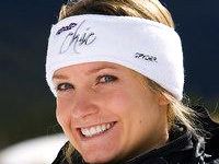
GARMISCH-PARTENKIRCHEN, Germany — World Championship super G bronze medalist Julia Mancuso (Squaw Valley) solidified herself as a contender for the 2013 Audi FIS Alpine World Cup super G title after tying for second Friday with overall leader Tina Maze of Slovenia.

Mancuso sits 65 points behind Maze in the title chase with two super G races remaining on the calendar, including a second on Sunday in Garmisch where Mancuso will be going for her fourth straight super G podium at the German resort.

Julia Mancuso

Julia Mancuso

“I want to win races so I’m going to fight for that first. I feel like in order to get a super G title you should win a race so that’s my first goal. And if I hit that goal, then I should have a good chance at staying in there for the chase,” Mancuso said.

Tina Weirather won to become only the second woman from Lichtenstein to claim a World Cup victory since her mother won Hanni Wenzel in 1984.

With 14 career super G podiums, Mancuso is tied for 10th on the women’s all-time super G podium list with Austrian Anita Wachter.

Laurenne Ross (Bend, Ore.) posted a solid ninth. Leanne Smith (N. Conway, N.H.) finished 12th and Stacey Cook (Mammoth Mountain) 30th.


Sport-specific weather apps help with planning

By Bill Saporito, Time

Skiers in colorado know that the weather in vail can differ wildly from that of Beaver Creek, just 13 miles west on Interstate 70. The National Weather Service may forecast snow for the Rockies, but the amount in ski areas can vary by an entire foot; it’s tricky to gauge where and when the most snow will fall.

“People up here said it’s just too unpredictable,” says Joel Gratz, a Boulder-based meteorologist and skier. “But that’s not exactly true.”

appHow does he know? About five years ago, Gratz began to analyze microclimates in the Rockies — which are influenced by widely variable topography and wind flows–and e-mail his friends with predictions on where the most snow would fall so they could plan accordingly.

Those powder-pinpointing emails became so popular that Gratz eventually ditched his day job consulting for an insurance company to start OpenSnow.com It’s one of a number of travel weather sites such as BestSnow.net BestSkiWeather.com and SnowForecast.com that are aimed at skiers and snowboarders on the move.

This burgeoning category of sites not only serves skiers but is also a boon for surf, trail, rod and gun travelers, especially those who don’t book far in advance. With a five-day window, travelers can point themselves toward optimal conditions for golf, tennis, fishing or hunting. Lodges and resorts benefit too, emailing powder alerts, for example, to attract last-minute bookings.

Surfers were first to take weather into their own hands.

“They were their own meteorologists,” says Jens Rasmussen, a co-founder of Solspot.com a wave and weather site.

By retrieving data from ocean buoys and weather satellites, surfing-centered sites such as SurfLine.com MagicSeaweed.com BeachLive.com and Solspot create algorithms to alert riders when an epic swell is due at, for example, Cortes Bank off the California coast or Jaws in Maui, Hawaii. (The surf sites have awesome videos too.)

Your average weather site probably wouldn’t forecast the scent cone — the area downwind from hunters that might give them away to their prey. ScoutLookWeather.com does.

“ScoutLook’s mission is to tell them precisely where, when and how to maximize that time afield by being in the right place at the right time,” says Cy Weichert, a co-founder of the site.

ScoutLook includes sponsored apps that allow fishers to photograph their catch and upload it; the site also records location and weather conditions for future reference — “say, how many lake trout have I caught in northwest wind on a fly,” Weichert says.

Right now, he’s focused on developing more-detailed apps for the hunting and fishing markets in the next year.

Golfers too are getting focused weather. GolfWeatherNow.com also run by Rasmussen, says it has forecasts for 6,247 courses in the U.S., plus information on course conditions and amenities. Meanwhile, the U.K.’s Advanced Weather Applications is trying to flood the zone with information for a variety of sports on sites like LatestGolfWeather.com plus ones for hiking, motor sports and other activities around the world. Rasmussen plans a similarly comprehensive mountain-to-ocean approach, as does ScoutLook.

Only problem with all these sites: if you don’t catch the best waves or the biggest fish, you can’t blame the weather.


Squaw athletes do well at Freeride World Tour

Current women’s snowboard tour leader Margot Rozies from Pyrénées, France, managed her first top podium finish of the season Wednesday at the SWATCH Freeride World Tour on The Cirque at Kirkwood Mountain Resort.

Rozies had a fast and fluid run. The judges awarded her with a score of 64.00.

Kirkwood provided a challenging course for competitors Feb. 27. Photo/Provided

Kirkwood provides a challenging course for snowboarding and skiing competitors Feb. 27. Photo/Provided

“I felt a bit sick today actually, but think that removed some of the pressure,” said Rozies. “I woke up this morning and considered not competing actually. However, I managed to get myself pumped for competition. It couldn’t have gone any better.”

Continuing on the women’s snowboard podium in second place was another French snowboarder from Annecy, Elodie Mouthon. She narrowly missed the top spot on the podium taking second place with a score of 63.67. Shannan Yates from Snowbird, Utah, chose a unique line compared to the rest of the competitors, which landed her the third with a score of 61.33.

Next were the female skiers. Topping the field for women’s ski competitors was Squaw Valley’s Jackie Paaso. Paaso needed to earn a podium position to improve her overall ranking on the tour and potentially progress to Verbier. She skied a very smart and controlled run linking a number of airs through technical sections of the venue. Her performance was awarded with a score of 71.67.

“I have had a number of crashes this season and really needed a win. It feels great to come out on top,” exclaimed Paaso. “I took my run down a notch this time because I needed to stay on my feet. Making it to the finish line was the best part for me.”

Rounding out the women’s podium was Pia Nic Gundersen of Ånstadblåheia, Norway, in second with a score of 67.00. Ashley Maxfield of Jay Peak, Vt., was third with a 63.00.

At the end of the day, it was Lars Chickering-Ayers out of Mad River Glen, Vt., who claimed the Kirkwood men’s title. He was rewarded a winning score of 75.33.

Julien Lopez of La Plagne, France, took second with a 73.00. Representing the Southern Alps of New Zealand, Charlie Lyons landed the third podium position with a 72.00.

The male snowboarders faced the most difficult conditions of the day as the afternoon brought low light conditions and firmer, settled snow to the venue. Wild card recipient Ryland Bell out of Squaw Valley was happy he accepted the special invitation to compete at the event. Bell earned first place with a score of 87.67.

Also out of Squaw, Sammy Luebke finished in second place with an 80.00. The final podium spot went to Emilien Badoux of Valais Alpes, Switzerland, with a score of 73.67.

The SWATCH Freeride World Tour by The North Face continues in Fieberbrunn Pillerseetal, Austria, on March 9, and concludes in Verbier, Switzerland, on March 23.

— Provided to LTN


TRTA putting on wilderness first aid class

The Tahoe Rim Trail Association is offering a two-day wilderness first aid course.

trtaThe cost for the April 13-14 class is $195 for non-TRTA members and $175 for TRTA members.

The course will be taught by the Wilderness Medicine Institute of NOLS. This course will provide individuals with a foundation in first aid concepts critical to responding effectively to emergencies in a remote backcountry environment.

The WFA course will help people prepare for the unexpected. This fast paced, hands-on training is designed to meet the needs of trip leaders, camp staff, outdoor enthusiasts and individuals working in remote locations. Classroom lectures and demonstrations are combined with realistic scenarios with mock patients.

Participants must be at least 16.

Successful course completion earns you a WMI Wilderness First Aid certification.

This course may also be used to re-certify WMI Wilderness First Responder and WMI Wilderness EMT (wilderness portion only) certifications.

For more information or to register, contact Hayley at (775) 298.0238 or programs@tahoerimtrail.org.


Dogs to race through snow in Truckee

On March 10, Snowfest returns to Tahoe Donner with the ninth annual I-Did-A-Run event.

snowfestDue to construction at the Lodge Restaurant & Pub, this year the event will take place at Tahoe Donner Downhill Ski Area.

Dogs of all shapes and sizes will compete in this timed dog pull race. The event pits dog against dog and clock while pulling covered wagon sleds over a snow-covered course. Prizes are awarded for various divisions as well as the overall winner.

Sign up is from noon to 1pm and the field is limited to 40 dogs.

For more information about the I-Did-A-Run email Ali Kovach at ekovach@tahoedonner.com or call (530) 587.9424.


California bill would require ski resorts to report injuries, deaths

By Joel Grover, NBC-4

A bill that would for the first time require California ski areas to report all deaths and injuries to the state has been introduced in the state Senate.

California’s 24 ski areas are largely unregulated, making the Golden State the only major ski state with no ski safety law. Previous attempts to enact legislation have failed, but in the wake of an NBC4 I-Team investigation exposing multiple dangers across the state, one lawmaker is trying again.

ski injuries“When there are injuries or deaths, that should be a matter of public record,” said state Sen. Bill Monning, of Carmel, who sponsored the Ski Safety Bill.

In early February, the NBC4 I-Team revealed that there are numerous injuries and deaths at California ski areas that are not required to be reported to the state or made public, including an accident involving 9-year-old Keely Proctor of Redlands.

Two years ago, Proctor fell 32 feet from a chairlift at Snow Valley that didn’t have safety bars. Keely had six surgeries in five days that saved her life.

“We could’ve lost her,” Keely’s mother Terri Proctor told NBC4.

The California Ski and Snowboard Safety Organization, a group advocating ski area safety, said there are hundreds of unreported accidents a year on the state’s ski slopes.

Monning’s bill would also require ski areas to prepare an annual safety plan to prevent accidents and lessen hazards on the slopes. Resorts would have to post that safety plan on their websites.

“It’s really a question of transparency and the public’s right to know. People are spending a lot of money to enjoy the resorts,” Monning said.

The Ski Safety Bill will be heard in committee within 30 days. If it passes both houses of the legislature, it will land on Gov. Jerry Brown’s desk in September. But that doesn’t assure its success.

Similar ski safety bills have passed the legislature twice in the past four years, but then were vetoed by governors, first by Arnold Schwarzenegger then by Jerry Brown.


Event is all about legendary mailman of the Sierra

The 14th annual celebration of Snowshoe Thompson is March 2 from 9am-1pm  at Picketts Junction.

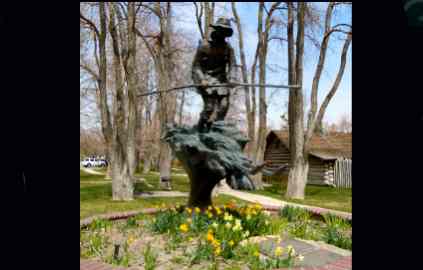
The Snowshoe Thompson statue in Genoa. Photo/LTN file

The Snowshoe Thompson statue in Genoa. Photo/LTN file

Nina MacLeod and Snowshoe Thompson (aka Steve Hale) will lead people on a ski-snowshoe tour through Hope Valley.

Registration and rentals are available at the yurt. (From South Lake Tahoe, go straight onto Burnside Road at the junction.) A $10 donation is requested.

This is a benefit for the Friends of Snowshoe Thompson to promote awareness about him and to maintain his statue in Genoa.

For more info, call Nina at (530) 573.8940 or Sue at (775) 315.7777.


Shore of Emerald Bay via snowshoes

By Kathryn Reed

EMERALD BAY STATE PARK – While it would have been nice to be able to start a fire at the campsite to warm up a bit, it was even better having the entire campground to ourselves.

As we descended to the shore of Emerald Bay, we were walking through a blizzard. Not everyone realized the bay was to our left as we snowshoed down. The visibility was that poor on Saturday.

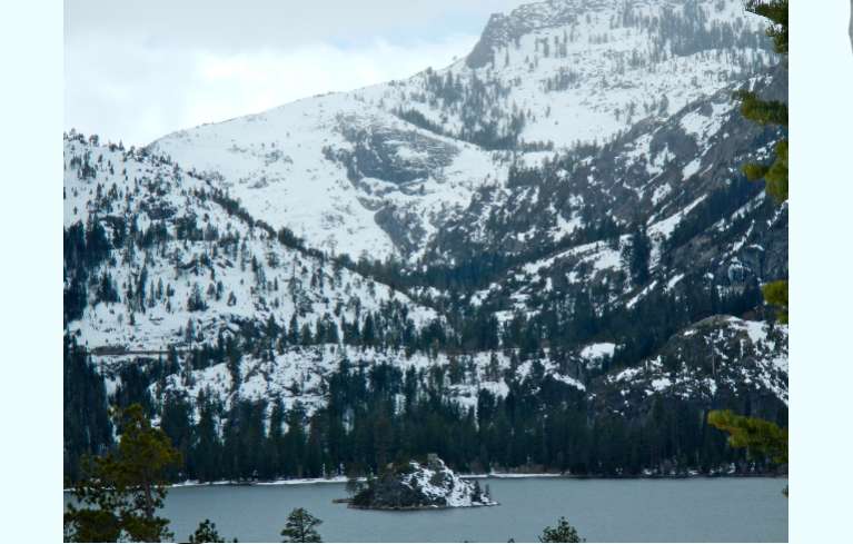
Emerald Bay from Eagle Point Campground. Photos/Kathryn Reed

Emerald Bay on Feb. 23 from Eagle Point Campground. Photos/Kathryn Reed

Freshies were gradually accumulating on the already snow-laden picnic tables in Eagle Point Campground.

(When we got back to South Lake Tahoe that afternoon there was no evidence it had snowed there.)

Trekking through this 100-spot campground on snowshoes is ideal. Seldom is anyone else there. The solitude and tranquility are abundant. But it’s the scenery that will give you pause and reason to take a camera.

Pines and cedar loom tall. Only the crunching of snowshoes can be heard.

Early on there is an opportunity to hook up with the Rubicon Trail. We go to the right, the opposite direction. Mostly we follow the snow-covered road. At one point we meander off to get a view of the water below.

And then when we do reach the bottommost campsite, we break trail to reach the bay.

There, the water laps against the rocks. Icicles have formed on some of the vegetation. On the far side of Lake Tahoe blue sky is peaking out. A couple boats ply the water.

Looking around, it is easy to understand why in 1969 Emerald Bay was designated a National Natural Landmark. This campground is part of the larger Emerald Bay State Park, which includes the whole bay and Vikingsholm. The state acquired the land in 1953 from Placerville lumberman Harvey West for half the amount of what it was appraised at. (The campground was closed last season for upgrades.)

The only thing that could have made the excursion better was if an eagle had soared overhead.

—-

Getting there:

From South Lake Tahoe, take Highway 89 north. Once you go through all the hairpin turns and are about to get on the stretch where Cascade Lake is on the left and Emerald Bay is on the right, the campground is on the right. Without snow, there is ample parking off the road.

ngg_shortcode_0_placeholder (Click on photos to enlarge.)


Glenbrook area controlled burn to be reignited

U.S. Forest Service fuels management crews will continue prescribed fire operations above Glenbrook on Feb. 26.

usfsCrews expect to burn approximately 20 acres per day, weather permitting. Operations will continue through the week as conditions allow.

Residents and visitors of the Lake Tahoe Basin, Carson City and Reno can expect to see smoke from these prescribed fire project areas. Smoke may be visible on highways 50 and 28.

The Forest Service strives to minimize the impacts of smoke on local communities. Smoke-sensitive residents should consider staying indoors and keeping doors, windows and outside vents closed.

To directly receive prescribed fire updates, send an email to pa_ltbmu@fs.fed.us.

Forest Service staff will post road signs around areas affected by prescribed fire, and update the local fire information line at (530) 543.2600, No. 6.


Martis Valley trail route selected

By Barbara Barte Osborn, Sacramento Bee

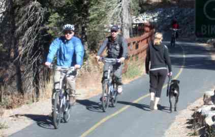
An alignment paralleling the south side of Highway 267 has been selected for a proposed 9. 5-mile multiuse trail through the Martis Valley near Truckee.

The Northstar Community Services District board voted for the alignment Wednesday after easements could not be obtained for an alternate route that would have followed an existing dirt road farther south through the valley.

trail“The Northstar Property Owners Association was not willing to grant easements for the valley alignment, and we respect that decision,” said Mike Staudenmayer, the district’s general manager.

The district is lead agency for the Martis Valley Trail, a controversial Placer County project.

“The highway alignment is also preferable to the Army Corps of Engineers and was found to be slightly environmentally superior in the CEQA (California Environmental Quality Act) analysis,” Staudenmayer said. “There are a lot of interested stakeholders, and we’re doing the best we can to do it right.”

The board also approved a design and consulting contract with Auerbach Engineering Corp. of Tahoe City for the first segment of the trail, from the Nevada/Placer county line to the wildlife viewing area.

Construction of that approximately 1-mile-long section is expected to begin next year.

Almost 3,000 feet of the initial section, within the wildlife viewing area owned by the Army Corps of Engineers, will not be paved initially but will have a packed surface, Staudenmayer said.

“We’re actively working with the Corps as (the trail project) progresses through National Environmental Policy Act review, hopefully within the next year,” he said.

The cost of the trail, from the county line to the Village at Northstar, is expected to be $12 million, of which the district currently has $4 million in grants – enough to build the first segment and design the rest, Staudenmayer said.

“We have more fundraising to do, but we hope to get it built as quickly as possible,” he said.

The plan is to extend the trail from Northstar’s Village to the ridge line overlooking the Tahoe basin, where it would connect at the Four Corners area with Forest Road 73, known locally as the “Fibreboard Freeway.”

The 10-foot-wide trail would be available to all pedestrian and non-motorized uses, with the exception of equestrians.

The only motorized use would be powered wheelchairs.