Comstock water system subject of tour

Former backcountry ranger and amateur historian Cheryl Surface will lead a tour of Spooner’s backcountry on Aug. 9.

She will share accounts of the people involved with the Comstock’s critical water source, the Marlette Water System, and histories of Red House, Hobart Reservoir, Marlette Lake and the Flume Trail. Space is limited to 12 people. Call (775) 684.2717 reserve a spot. Cost is $20. This is for adults only. No pets allowed.

Bring lunch, water, a light jacket, a camera and comfortable shoes for walking at stops along the SUV tour.

The tour is from 9am-4pm. Meet at Spooner Lake Park’s upper parking lot.


Illegal trails cropping up in Lake Tahoe Basin

By Kathryn Reed

A new bike trail is going in at Carnelian Bay. Trees are being felled, berms created and gap jumps installed.

And whoever is creating this trail on U.S. Forest Service property could wind up in jail and having to pay a fine.

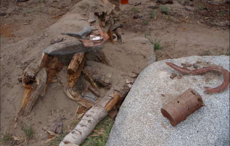
Cultural resources have been disturbed in the process of creating this unauthorized trail, which found on the South Shore several years ago.

Cultural resources like these were unearthed in the process of creating this unauthorized trail on the South Shore several years ago. Photos/Provided

“When we have to obliterate unauthorized trails, it takes crews away from building other projects,” Cheva Heck, USFS spokeswoman, told Lake Tahoe News.

This is one of a few trails that has been discovered this summer in the Lake Tahoe Basin. Others are near Tahoma and Cave Rock. The Carnelian Bay trail is the most destructive because trees have been cut down. It was about a half mile long when crews discovered it.

While the feds don’t have any suspects at this time, surveillance has been set up.

“I would rather have the Forest Service spend its limited trail budget on new trails than destroying illegal trails that are perhaps causing resource damage,” Kevin Joell, president of Tahoe Area Mountain Bike Association, told Lake Tahoe News.

TAMBA has been working with the Forest Service to create trails throughout the Lake Tahoe Basin. While working through the government process can take time, the end result is a trail built to current standards that takes safety and other issues into consideration.

“If someone has the energy to build trails, if we can harness that, we can talk to them on a peer level to find out what they want and explain what it would take to do it legally,” Joell said.

Illegal trails are not built to safety or other standards.

Illegal trails are not built to safety or other standards.

The problem with illegal trails is that they can cause erosion problems, disturb cultural resources and not be safe.

The illegal trails are often built near an existing trail but do not directly tie into it. This is so it won’t be detected so easily. It’s by word of mouth that the illegal trail is discovered. It might require carrying a bike or a bit of cross country.

“We want people to work with us if they want to make trails,” Heck said.


Learn about owls in Genoa

Wildlife biologist Jenni Jeffers will be releasing an owl Aug. 14 following a presentation at Mormon Station State Historic Park.

Jeffers will show several live native owls as she discusses the life cycle of owls, their habits, habitats and how the public can help in their conservation.

No photographs or dogs are allowed.

The free event is from 7:30-9pm.

Meet in the group pavilion area of the park. Mormon Station State Historic Park in Genoa is 20 minutes from South Lake Tahoe via Kingsbury Grade and Foothill Road.


Learn about fens in Washoe Meadows State Park

Jerry Qualls will lead a tour of the special wetlands in Washoe Meadows State Park on Aug. 7 from 10am-noon and explain why they are important to the health of Lake Tahoe.

Qualls is an associate professor in the Department of Natural Resources and Environmental Science at UNR. His areas of interest and expertise include hydrology, geomorphology, wetland ecology and management as well as fens.

Meet at 10am at the end of Ulmeca Street in South Lake Tahoe.

For more info, contact Lynne Paulson at (408) 823.6585 or LCPaulson@comcast.net.


Forest Service explains river restoration work

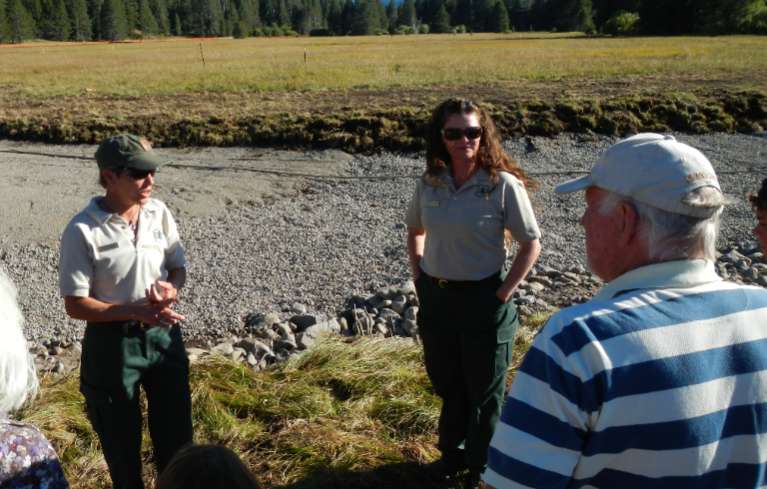
Sue Norman and Stephanie Heller with the U.S. Forest Service talk in front of the new channel of the Upper Truckee River. Photo/Kathryn Reed

Sue Norman and Stephanie Heller with the U.S. Forest Service talk in front of the new channel of the Upper Truckee River. Photo/Kathryn Reed

By Kathryn Reed

Not everyone is buying what the U.S. Forest Service is selling.

What the feds are selling is that changing how the Upper Truckee River flows is a good thing. What many on a tour of the project weren’t buying is whether this four-year $4 million project is needed.

Seventeen people on Aug. 2 meandered through the meadow on the other side of Lake Tahoe Airport looking at the work that is under way and how the current river flows.

“How do they know it will be what they say?” Louise Wigart said to Lake Tahoe News.

The Forest Service points to High Meadow and Cookhouse Meadow as being successful restoration projects.

Wigart’s husband, Corky, called it “overkill.” He’s been canoeing, fishing and hiking on and along the river for decades and sees no need to create a new channel. If something needs to be fixed, fix the existing channel is his philosophy.

But that strategy isn’t being used on any section of the river. Instead, the respective owners are each gradually rerouting the river in an attempt to restore the meander to what it was before humans changed it decades ago. Officials say working in the existing river is cost-prohibitive and would lead to greater degradation of lake clarity.

The goal is to put more curves in the river. Some sections had been straightened during grazing, logging and quarry operations. Curves will slow down the rate at which the water travels. This in turn is designed to lessen the erosion on the banks.

The Upper Truckee River, according to scientists, is the No. 1 contributor of fine sediment to Lake Tahoe. That sediment is what the same scientists claim contributes to the decline of lake clarity.

While this project is about keeping the lake clear, that is not the primary goal.

“This is mostly an ecosystem project,” Stephanie Heller with the U.S. Forest Service told those on the Friday tour. She said raising the water table and providing more habitat are critical components of the project.

The channel today is deep. The eroding banks impossible to miss. The meadow bone dry.

And while the meadow may be dry in August in the future, that will not be the case in early summer. The new channel is being designed so it will be shallower, flow at about one-fourth the rate of the current channel, all with the expectation it will flood the meadow two out every three years.

Some people along the tour questioned whether the project is going to really have an impact on lake clarity.

It is the overall reduction of sediment that is measured, not individual reaches.

There will be another tour of the project on Oct. 25.


Meeting to address concerns of Tahoe Ironman

A meeting on Aug. 6 will focus on community impacts of September’s Ironman Lake Tahoe.

The 5:30pm meeting will be at the North Tahoe Event Center in Kings Beach.

The sold-out triathlon is Sept. 22. More than 2,500 athletes will be competing.

Race director Keats McConigal, assistant director Todd Jackson and course director David Reid will be attending the meeting. The three will go over traffic concerns, race impacts, and the economic benefit the race will have on the area. Following the presentation there will be time for audience questions.

The course runs throughout most of North Lake Tahoe. It starts at Kings Beach State Recreation Area and cyclists will pedal through Truckee and over Brockway Summit before the event ends at Squaw Valley.


Jeepers mix ruggedness with modern conveniences

By Ed Fletcher, Sacramento Bee

When it comes to camping, there are generally two types – car campers, who cling to modern conveniences, and backpackers, who sacrifice convenience to reach secluded destinations.

Jeepers insist on having the best of both worlds.

For 61 years, off-road enthusiasts have sandwiched a two-day campout and party at a modest “valley” that was once the home of the Rubicon Mineral Springs Resort between their sometimes-treacherous 7.5-mile treks in and out on one of the world’s most iconic jeep trails.

This year, 543 people paid more the $350 a person to take part in last weekend’s Jeepers Jamboree. While most of the participants were from California, some came as far as Norway to experience the Rubicon Trail.

Read the whole story


Astronomy night in Washoe Valley

Astronomy experts Jay Lawson and Adam Kremers will set up their high-powered telescopes to view Saturn, the Milky Way galaxy and many other objects in the night sky.

The Aug. 10 event is at Washoe Lake State Park from 8-10:30pm.

Meet at the overflow boat parking area which is next to the group reservation area. Washoe Lake State Park is five miles north of Carson City.

There is no charge for the program, but there is a $7 per-vehicle entry fee.


USFS launches new fire safety campaign

The U.S. Forest Service and other land management agencies have a new fire safety campaign in California. The One Less Spark, One Less Wildfire campaign is designed to provide constant reminders during this fire season to reduce the numbers of human-caused vehicle and equipment wildfires throughout the state.

“All the stories we hear about sparks starting wildland fires are true, especially during this hot, dry summer,” said Joe Aragon, U.S. Forest Service Region 5 Interagency Fire Prevention Action Team coordinator, said in a statement. “With the low precipitation winter brought, conditions are ideal for fire starts. We’re here to coordinate with communities, agencies, organizations and schools to heighten awareness and ultimately protect the public from damaging fires in order to create more fire-adapted communities.”

The campaign features posters, bumper stickers, informational cards and public service announcements which give safety messages about equipment such as lawn mowers igniting fires, tow chains sparking fires along roadways, and safe handling of campfires.

Partner agencies include: National Park Service, Bureau of Land Management, CalFire, Caltrans, California Department of Fish and Wildlife, U.S. Fish and Wildlife Service, Bureau of Reclamation and many others.

Fire season in California has technically just begun, and already campfires have been blamed for 45 fires on national forest land. Thirteen fires have been sparked by equipment such as string trimmers, chain saws and mowers. An abandoned campfire started the 1,708 acre Carstens Fire on the Sierra National Forest near Yosemite, costing millions of dollars.


Human impact on Yosemite may be reduced

By Norimitsu Onishi, New York Times

YOSEMITE NATIONAL PARK — Far humbler corners of America have faced a similar dilemma: How much human activity should be allowed in a natural setting that is also promoted as a tourist destination?

The National Park Service is proposing a significant makeover of Yosemite National Park that would change the way future generations of visitors experience the park, especially the seven-mile-long Yosemite Valley at its heart. The Park Service’s plan would restore more than 200 acres of meadows, reorganize transportation and reduce traffic congestion. To shrink the human presence along the Merced River, park officials are also proposing closing nearby rental facilities for bicycling, horseback riding and rafting, as well as removing swimming pools, an ice rink and a stone bridge.

As with most things related to one of the nation’s most beloved national parks, the plan has ignited fierce debate among environmentalists, campers, and officials in California and Washington.

Rep. Tom McClintock, a Republican whose district includes Yosemite, said at a recent House hearing that the idea of removing commercial facilities was meant to satisfy “the most radical and nihilistic fringe of the environmental left.” But some environmentalists said the plan did not go far enough in protecting Yosemite Valley and the Merced River, which flows through 81 miles of the park.

Read the whole story
