Ride with pro cyclists to raise cash for regional trail

Cycling enthusiasts are invited to meet and ride with Tour de France champion Andy Schleck and cycling legends Jens Voigt and Frank Schleck at two events to show support for the Tahoe-Pyramid Bikeway and the Tour de Nez.

The athletes will be in the Tahoe-Reno area to train for the USA Pro Cycling Challenge in Aspen.

The cyclists will be at the old Reno Arch at the Siena hotel Aug. 15 from 8-9am. The ride departs the Siena at 9am and takes a scenic tour through Reno at a leisurely pace (15 mph) and concludes at Galena Market on Thomas Creek Road.

A donation of $25 for the ride and $100 for ride and photo opportunity is suggested and benefits the Tahoe-Pyramid Bikeway.

Advanced riders can go with the pros up Mt. Rose Highway.

On Aug. 16 at 9am will be a meet and greet the pros at the Homewood-West Shore Café parking lot; then a ride with the pros for the first 20 miles of their training ride.

A donation of $25 for the ride and $100 for ride and photo opportunity is suggested and benefits the Tahoe-Pyramid Bikeway.


Northstar to be site of 3-day bike race

A three-day, two-person mountain bike stage race that will involve nearly 150 miles of pedaling is set for Oct. 11-13 at Northstar.

It will include more than 30,000 feet of total elevation gain on some of the resort’s singletrack terrain.

Unlike many established multi-day mountain bike stage races, where riders endure long transfers, nights spent huddled in tents or gymnasiums and force down lackluster meals, the Epic Events formula is to make an elevated experience available to all racers and to structure their events so family members and friends can tag along.

Other features of the Epic Northstar include an option for racers to have their bike professionally washed and tuned between stages, daily massages and the richest prize purse in the country at more than $100,000.

Registration for the Epic Northstar event is open. To help riders better understand the challenge at hand, there will be several weekends of course pre-riding with elite riders.

For more information, contact Mark Riedy at (415) 302.2923 or mark@trueoverdrive.com.


Invasive weed threatens Calif. vineyards

By Edward Ortiz, Sacramento Bee

A new invasive weed has been expanding exponentially along roadways in the Sacramento region and the state, prompting plant scientists to warn that its unchecked growth could end up costing taxpayers millions of dollars.

The new weed, named stinkwort for its turpentine-like odor, threatens to choke out native plant species. The weed also has begun appearing in vineyards, raising a concern that it could affect the flavor of some grapes in the state’s premier wine-growing region.

The low-lying weed, known by the botanical name Dittrichia graveolens, is a relative newcomer to the state, making its first appearance near Milpitas in 1994. It resembles a tumbleweed, and rarely grows taller than 3 feet. Its flowers are small and sport tiny yellow petals.

To the east, the weed has been seen on the side of roadways such as South Shingle Road in Placer County and in Diamond Springs in El Dorado County.

Read the whole story


Tahoe wilderness anything but desolate

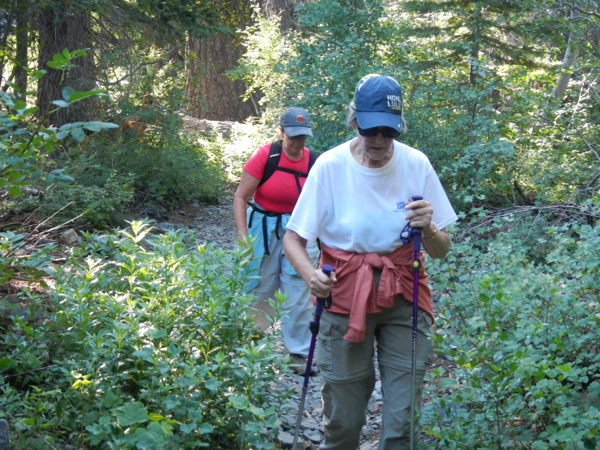
Trekking through Desolation Wilderness. Photos/Kathryn Reed

Trekking through Desolation Wilderness. Photos/Kathryn Reed

By Kathryn Reed

FALLEN LEAF LAKE – With 63,960 acres to explore in Desolation Wilderness, it’s not necessary for the quest to be a peak. But if being on top of the world is the goal, there are plenty of mountaintops to choose from – including Mount Tallac.

Last month mom, Sue and I started off about 7am to see how far we could walk in this wooded area that spans the Lake Tahoe Basin Management Unit and Eldorado National Forest. We began the Sunday hike at Glen Alpine trailhead.

Cleo Reed and Sue Wood hiking in Desolation in July.

Cleo Reed and Sue Wood hiking in Desolation in July.

The rule is that you are supposed to fill out a form and attach it your daypack or backpack if staying overnight. This helps the U.S. Forest Service know where people are and how many are using this popular area. But there are no forms. I left a sheet of notepaper – just in case something goes awry someone might come looking for us.

It doesn’t take long and I’m hitting myself. Sue and mom are swatting a bit, and we are all whining. Mosquitoes. They are everywhere. Later that night I’m scratching and those two are just looking at me.

It was so bad that Sue was asking backpackers on their way out if they had any bug juice they would share. Finally, one guy had some extra repellent wipes that we offered to pay good money for. He said take them; he wouldn’t need them. I can’t imagine how many welts I would have had if we hadn’t applied some chemicals.

Another guy coming out was hiking with his Great Dane. All four paws were wrapped with what looked like human socks and the dog was limping. Later we saw a volunteer from and the chief of Fallen Leaf Lake Fire Department lifting the dog into a pickup to truck it out.

The start, and therefore end, of the trail is super rocky. It’s the worst part of the hike because when you are tired coming down, it’s so necessary to keep paying attention.

Going up, though, the scenery is stunning. This is when you want your eyes focused ahead or even up higher when possible. (Except when climbing all those steps.) Desolation was designated a wilderness area in 1969. This means it will be protected to keep it essentially the way it was when first discovered.

Groups of pine cones in the treetops look like small bunches of bananas.

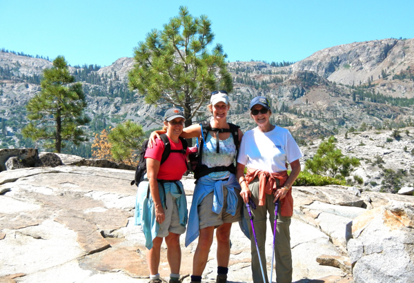
Sue Wood, Kae Reed and Cleo Reed surrounded by wilderness.

Wilderness surrounds Sue Wood, Kae Reed and Cleo Reed.

Indian paintbrush, yarrow and thistles are in bloom.

At times if feels like we are in a bowl of granite. It amazes us how in short order we are immersed in wilderness.

As we keep going the elevation starts to affect mom. The other time she felt like this she was in the Alps skiing between Switzerland and Italy. Altitude sickness was setting in. She was feeling lightheaded. We stop. Drink water. Eat. And we head back. Still, we did 7.5 miles on this trek.

Had we kept going, we would have ascended Mount Tallac. This is the route the Forest Service suggests for seniors (my mom is 78) and those with bad knees. Still, hiking poles can be a good idea.

Plenty of lakes are off this route, too – Aloha, Susie and Gilmore to name a few.

—-

Notes:

Trailheads in Desolation Wilderness:

Lake Tahoe Basin Management Unit:

• Echo Lakes

• Glen Alpine

• Mount Tallac

• Bayview

• Eagle Falls

• Meeks Bay

Eldorado National Forest:

• Loon Lake

• Buck Island

• Van Vleck

• Rockbound

• Twin Lakes

• Lyons

• Pyramid Creek (Twin Bridges)

• Ralston

• Echo.

Getting to the Glen Alpine trailhead:

From South Lake Tahoe, take Highway 89 north. Turn left on Fallen Leaf Lake Road. Follow the road around the lake, the store will be on your right, keep going, stay to the left when you have a choice to go right toward Stanford Camp. You will run into a parking area. If fills up fast on weekends, so arrive early.


Hike retraces steps of Donner Party

Hikers can travel the footsteps of early emigrant’s journey across the Sierra Nevada mountains Oct. 5-6 by participants in the 21st annual Donner Party Hike.

Participants can choose from seven hikes on Saturday, and a walking tour on Sunday. All hikes offer insight into emigrant history from local area guides, along with invigorating recreation and beautiful scenery.

New this year, is the Summit Meadows hike which travels along Lake Van Norden with stops to see rocks with mortars and other remnants of emigrants passing through.

In addition to the new hike, there are six other hike options of varying length offered that Saturday. Explore the Dutch Flat Donner Lake Wagon Road and 1913 Corridor Lincoln Highway with views of petroglyphs, old roadside billboards and the China Wall. Hike up Roller Pass and/or Mt. Judah to see where wagon trains were winched up over the granite. Discover pristine High Sierra Lakes.

Following the Saturday hikes, participants can enjoy a hamburger lunch and a presentation by Ethan Rarick, author of “Desperate Passage – the Donner Party’s Perilous Journey West”. This up-to-date narrative history of the Donner Party provides a compelling look at this frontier drama.

Sunday starts with a more relaxed walking tour departing from the Donner Camp Picnic Area, located on 2.5 miles north of Truckee on Highway 89. Following the walking tour where guides will detail the Donner Party’s encampment, participants will drive to Donner Memorial State Park to hear more about the Donner Party, the Pioneer Monument, visit the Murphy’s Cabin Site, and enjoy entrance to the museum offering a historical movie about the Donner Party.

Saturday’s hikes begin and end at the Mt. Judah Lodge at Sugar Bowl Ski Resort. Guides will lead groups of approximately 10-20 people to interpretive spots giving detailed historical information focused on emigrant and area history.

Space is limited for all events and reservations are required. Early registration for the Saturday hikes is $45 ($50 after Sept. 20) per hiker and includes a guided hike, commemorative ball cap, hamburger lunch and afternoon presentation. Sunday’s walking tour is $15 and includes the guided walk and entrance to the Emigrant Trail Museum. A two-day hike package is $60 ($65 after Sept. 20).

Complete hike descriptions and registration forms can be found online or by contacting the Truckee Donner Chamber of Commerce at (530) 587.8808.


S. Tahoe dog agility course location changes

When the South Lake Tahoe City Council in July 2012 approved money for K9 agility features the plan was they would go in the back of the dog park off Al Tahoe Boulevard.

Now they are going to be next to the main parking lot across from the dog park, but still in Bijou Community Park. The belief is this is be better so the park never has to be closed to the public while officers train.

The city said the Disc Golf Association is OK with the location and that it will not interfere with the disc golf course.

The fence is going up and the equipment is ordered.

The agility equipment will be available for public use when officers are not training. Training sessions will last no more than 20-30 minutes a few days a month.


Gliding makes flying a peaceful experience

A Piper Pawnee tows the glider to an elevation where it can fly on its own. Photos/Kathryn Reed

A Piper Pawnee tows the glider to an elevation where it can fly on its own. Photos/Kathryn Reed

By Kathryn Reed

MINDEN – Ten thousand feet in the air without an engine. And I only have myself to blame. I pulled that yellow knob and the plane with an engine went one way and we went another.

At this speed – about 55 knots – it would have been easy to pick out hikers along the Tahoe Rim Trail. Instead, this section on Friday morning was a vacant swath of dirt.

It was as though I could reach out and touch the treetops. We weren’t really that low, but going this slow made individual trees standout. That doesn’t happen in a power plane or helicopter. We were on the crest of the east side of the Lake Tahoe Basin coming up from the Minden airport.
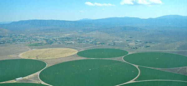
Alfalfa fields near the Minden airport

Alfalfa fields near the Minden airport

The lack of an engine made it so tranquil. While not silent because of the whir of the wind against the glider, there is no need for headsets to communicate with pilot Elizabeth Tattersall.

“It is such a thrill to stay up without burning fuel – to use just what Mother Nature provides,” Tattersall says.

She points out the iconic landmarks of Jobs Peak, Heavenly, Spooner Lake, Glenbrook Bay. The list goes on with a 360-degree view of Tahoe.

Leading up to the lake the tow plane takes us over the Carson Valley where dirt fields and those green with alfalfa, some square and some circular, fill the landscape. Large houses stick out – and there are many of them.

As we approach the Sierra, Mount Tallac is framed in the distance – while still impressive, it’s a bit dwarfed from this perspective.

I could float up there for hours just watching the scenery of Tahoe and her peaks – Pyramid with a dollop of snow; the lake shimmering in shades of blue that rival a Crayola box; the trees with stories to tell. But we must be back by sunset because this bird has no lights because it has no engine to power them.
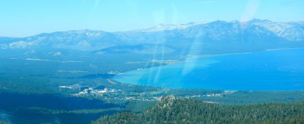
Lake Tahoe and the South Shore from 10,000 feet.

Lake Tahoe and the South Shore from 10,000 feet.

Soaring NV has been around for five years as a school and scenic tour company. With the thermal patterns, it’s a destination for people wanting to fly long distances.

Michael Marshall, who works for the glider company and is a pilot, possibly set five records for juniors earlier this week with his 350-mile flight that took him to Independence and back. (The paperwork needs to be submitted and the state must verify it.)

Lenticular clouds – the ones that look like a UFO – are common to this region in spring and late fall.

“Those are air waves. When that happens, it’s like nature’s elevator,” Soaring NV owner Laurie Harden told Lake Tahoe News.

A lot of what makes the Tahoe area difficult for power pilots in the summer is what glider pilots love – the thermal pockets. Those lift the glider, allowing a plane to keep soaring.

Mineral Peak, which is about seven miles from the Minden airport, is a location for gliders to head to because of the lift.

Tattersall sees the concave nature of the bottom of a cumulus cloud that is on the mountain ride. That, she says, is going to keep this bird in the air even longer. It got us 200 more feet.

The ASK21 weighs about 850 pounds and can carry about 400 pounds.

The ASK21 weighs about 850 pounds and can carry about 400 pounds.

For those looking for a unique wedding setting, Tattersall is also a reverend and has performed nuptials in the air.

Soaring NV will be at the Aug. 24 Lake in the Sky Air Show at Lake Tahoe Airport.

“I do believe they are the prettiest manmade thing in the sky,” Harden said of gliders.

While many of the aircraft at the South Lake Tahoe show are military in nature, gliders have played a role in this country’s history. They were used to sneak troops into France during War World II.

Most gliders, including seven of the eight Soaring NV has, are made in Germany. Because Germany cannot make power planes based on treaties agreed to at the end of the war, it turned to gliders.

—-

Notes:

• Lake in the Sky Air Show is Aug. 24 from 8am-4pm at Lake Tahoe Airport. More info is online.

• More info about Soaring NV is online.


Carson Valley bear caught and relocated

A male black bear was tranquilized in Douglas County on Friday morning by wardens from the Nevada Department of Wildlife and was to released this evening in the Carson Range.

The yearling male weighing between 80 and 100 pounds was found up a tree at a residence in the Gardnerville Ranchos.

“We have the most success with aversion conditioning on bears like this. They are young and respond to the aversion treatment,” Carl Lackey, biologist with NDOW, said in a statement. “The rubber buckshot and the bear dogs chasing them make an impression that will hopefully keep them wild.”

NDOW is also noticing bear activity is picking up in Verdi. No traps have yet been set in the area.

“We have reports of bear activity in the Gold Ranch area near the homes and businesses right off Interstate 80 and in the older section of Verdi,” Lackey said. “People need to secure their garbage and do all they can to keep the bears from gaining access to it.”


Needle miner turning section of Tahoe orange

By Kathryn Reed

An orange tinge appears to be hovering over parts of the Al Tahoe neighborhood. It’s needle miner.

Needle miners are small insects that are in the moth and butterfly family. And they are native to Lake Tahoe. But this is the first time there has been noticeable activity of the insect in the basin.

Bob Harms, who lives in the South Lake Tahoe neighborhood, said he first started noticing the discoloration of trees last year, with it being even more evident this spring.

Trees in the Al Tahoe area of South Lake Tahoe are orange from the needle miner. Photo/Kathryn Reed

Trees in the Al Tahoe area of South Lake Tahoe are turning orange from the needle miner. Photo/Kathryn Reed

This led him to do some calling and learn that it’s the Jeffery pine needle miner doing the damage.

The bulk of the brown-orange needles can be seen on Los Angeles Avenue, along Oakland Avenue and with spotty sections heading into the neighborhood toward the lake.

Beverly Bulaon, forest entomologist for the Southern Sierra region of the U.S. Forest Service, is tasked with dealing with such critters. She works out of the Stanislaus National Forest office in Sonora.

“It is a very small little insect that feeds in the needles,” Bulaon told Lake Tahoe News. “Why it is occurring in the Al Tahoe neighborhood we don’t know.”

She said there is the possibility it will spread to other areas in the basin, but with this being the first year her team has been aware of the outbreak on the South Shore, it’s too soon to know many details other than the insect is active in this one location.

The insect is killing the needles, but not the whole tree. And because much of the damage is at the crown, limbing the tree is not an option to rid it of the needle miner.

Bulaon said what could eventually kill a tree is a secondary insect coming in and injuring the pine. How healthy and strong the tree is before the needle miner comes will determine its resiliency because trees can survive after being attacked by the insect.

Drought is a possible reason for the recent infestation, Bulaon said.

On July 30, Bulaon and a group from the California Pest Council toured the Al Tahoe neighborhood looking at the needle miner damage. Some neighbors tagged along. Now the neighbors are forming a loose knit group to keep an eye on whether the needle miner damage spreads or goes away.

Bulaon suggests people call their local U.S. Forest Service office if they are concerned needle miners are infecting their neighborhood.


12-week class to become master gardener

People who have aspired to learn more about high elevation gardening and landscaping and want to encourage other gardeners by sharing science-based, sustainable gardening and landscaping information may want to become a master gardener.

Training to become a Lake Tahoe master gardener will begin Sept. 6 in South Lake Tahoe. The training continues for 12 weeks each Friday from 1-5:30pm.

Tahoe basin residents from California and Nevada may participate.

The University of California Cooperative Extension-Central Sierra, in partnership with the Tahoe Resource Conservation District, is offering this year’s Lake Tahoe Master Gardener volunteer training. Upon completion of the 50-hour training course, certified Lake Tahoe master gardeners will provide the community with research-based information about home horticulture and gardening.

The training will consist of core programs in horticulture and botany, native plants, soils, irrigation, pest management, plant nutrition, diseases, soil health, forest health, wildfire defensible space considerations plus additional topics specific to the Lake Tahoe Basin.

Once certified, master gardeners volunteer 50 hours during their first year of service and 25 hours in subsequent years. Volunteer activities include answering questions via email, phone and at events such as the farmers’ market; developing and teaching workshops and classes; one-on-one consultations; writing articles for the media; as well as other outreach and educational opportunities.

The application is available online and is due by Aug. 14 at 5pm. For questions, call (530) 621.5528.