Thinning project to impact TRT users

The U.S. Forest Service Lake Tahoe Basin Management Unit will begin a large-scale tree removal project Sept. 8 near Page Meadows off of Chamonix Road.

The project uses a masticator to reduce material left behind after fuels reduction thinning. A masticator is a large lawn-mower type of heavy equipment that runs over debris and chops it up into smaller pieces. Flying debris from mastication equipment is common and large chunks of woody material can be thrown up to 500 feet.

Approximately 375 feet of the Tahoe Rim Trail crosses through the project area and there will be a one- to three-day period when equipment will be working near the trail. For public safety, hikers may experience a short delay while the equipment is stopped to allow safe passage.

Project work is expected to take approximately six weeks to complete and work will occur on weekends.


Death Valley’s Racetrack seems otherworldly

The Racetrack in Death Valley is mesmerizing. Photos/Toogee Sielsch

The Racetrack in Death Valley is mesmerizing. Photos/Toogee Sielsch

By Toogee Sielsch

DEATH VALLEY NATIONAL PARK – “It’s your call Ian. Do you want to spend the night around here and check out Scotty’s Castle in the morning, or should we drive the 27 more miles on dirt roads, in the dark, and check out that Racetrack thing in the morning?”

“Racetrack!(?)” Ian replies.

“Good answer!”

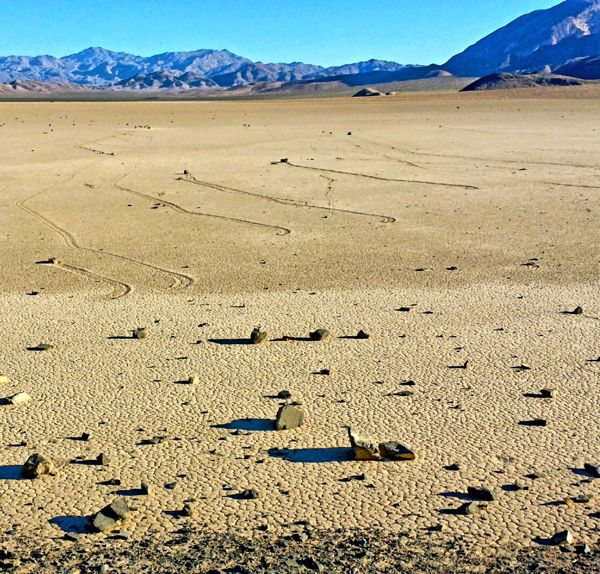
The Racetrack – a true scientific enigma until just this last year. Located in the northwest end of the Death Valley National Park, but many miles from Death Valley proper. The Racetrack is a dry ancient lakebed that sits at 3,600 feet. Its playa runs almost due south to north, is just less than 3-miles long by almost 1½-miles wide.
It’s also extremely flat. The difference in altitude from the south to the north end is barely 1.5 inches (4cm), which is basically attributed to a larger buildup of fine sediment at the north end.

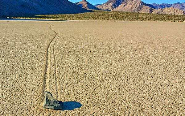
It’s in a basin that is surrounded by spectacular colored mountains rich in minerals and even has evidence of an abandoned mining operation above the playa to the southeast side. Named “The Racetrack” for the rocks, called sailing stones, that somehow travel in a mostly south to north pattern across the playa leaving, depending on the size of what is moving across the lake bed, ruts in the rock hard, cracked dirt playa surface. We even found some thick tumbleweed branches that had felt inclined to join the rocks in their quest for the north end of the playa.

Rocks find their way onto the playa.

Rocks find their way onto the playa.

There have been many different stories and interpretations of this phenomenon, and most were centered on three elements. The perfect combination of water on the playa turning its surface into a slick and wet mud flat, freezing temperatures create a thin ice layer above the mud, and strong wind. But until just recently when a research team from UC San Diego used video, attached GPS units on some rocks they introduced onto the playa, and were even lucky enough to witness the phenomena, no one knew just exactly how, or even how fast these playa objects moved. Rocks varied in size from those weighing an ounce to those weighing upward of 100-plus pounds. The team clocked some of the rocks moving up to 20 feet per minute. That figure is not a typo. Up to 20 feet per minute, and some movement with winds as light as 10 mph. And as evidenced by their trails, their movement is only sometimes in a straight line. To paraphrase Bob Dylan, “These rocks don’t need a weatherman to know which way the wind is blowing!” The phenomenon takes place on the backside, or thawing phase, of a wet/freeze/thaw/wind event.

Never had I thought too hard about, but I had thought about it before on occasion, the question as to where the rocks came from. As we drove toward The Racetrack in the dark on fairly well maintained dirt roads the question grew in my mind. Along the drive something that stood out under the dark star-filled sky was the silhouette of the peaks and ridges all around us. Not the nice rolling landscape in meadow scenes, but stark hill and mountainsides with steep rocky inclines. By the time we arrived at the southern end of the playa, which was about 10:30pm, our first order of business was to walk out onto the playa a couple hundred yards and get a feel for the place. The sliver of a moon had already set, but the crystal clear sky was literally dirty with stars that emitted more than enough light to get a feel for the landscape that surrounded the playa. We even found a couple of small racers with their tracks leading off into the dark to the south of us.

It was time to hit the sack and get some rest. Sleep came fitfully, in part because of my excitement of what the morning light would reveal, coupled with a night sky literally overflowing with stars making me reluctant to close my eyes for fear of missing something.

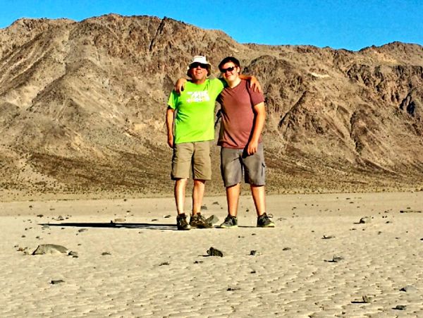
Toogee and Ian Sielsch explore The Racetrack.

Toogee and Ian Sielsch explore The Racetrack.

First light roused me from a deep sleep, and looking over at my navigator/co-pilot/ favorite youngest son, Ian, I knew he was an hour plus from waking. Time to go explore before the sun heats things up. Walking out on the hardpack cracked playa in the early morning with little air movement had an eerily calming effect akin to looking at sheer glass on Lake Tahoe in the early morning. Becoming more alert with every step onto the playa my attention was drawn to the south and southeast end of the playa, all the while walking among the “sailing rocks” and their trails. Now I want to clarify that the playa is not “littered” with these hapless racers. But the closer I approached the southern end, and many more racers are present, the answer to my nagging question was revealing itself. On that southern end and on the southeastern edge, there are steep inclines of rock outcroppings that sit about 6 feet back from the playa surface. The landscape around the rest of the playa, although ringed with steep ridges, has a gentler incline running hundreds of yards to the base of the inclines. Within that six feet sits a gravely pebble field.

Now I’m pretty sure that the scientists studying this phenomenon were quite content that the answer to my inner question was so rudimentary that they felt no need to highlight this point. But as I inspected this area that seemed to produce the highest amount of racers I felt that it was a very important part of the equation. This six-foot zone was the make or break for many of our rock racing friends. Without actually contacting the surface of the playa, it was quite evident that there would never be a chance of it being part of the legacy of rock racers. Which brought me to the conclusion that – tada – a rock, or a multiple rockslide must have enough velocity as it runs down a 30-plus percent grade (I’m guessing) to cross a rock strewn surface almost completely flat measuring about six feet to become a “Playa Player”!

Without being on the cracked, hard packed surface of the playa that rock’s dreams will never have a chance to be realized.

And in my world, rocks have hopes and dreams!

—-
Getting there:
If entering the park on California Highway 136 from Lone Pine, continue onto Highway 190 through Stovepipe Wells, then turn left about 6.3 miles on the road north to Scotty’s Castle for about 33 miles. When arriving at the junction, take a left to the Ubehebe Crater, than enter the dirt road on the Ubehebe Crater loop to the 27 miles to The Racetrack. The route we took was out of Big Pine taking Highway 168 to the Death Valley Road turnoff, and then on to the Scotty’s Castle Junction that is 76 miles, 60 miles or so on well cared for dirt roads. Then take a right to the Ubehebe Crater Loop.


Time to give kids more freedom to explore

By Katie Arnold, Outside

Even if you’re not ready to yank your kid out of fourth grade to let them run loose in the woods, there are plenty of ways to give your kids more freedom to learn on their own while still sending them to school.

Start at home by encouraging them to follow their passions and explore subjects that interest them.

“It doesn’t matter where or when you do it. The main thing is to show kids that they can teach themselves,” says Leo Babauta, 41, father of four unschooled children ages 8 to 17 and founder of the blog Unschoolery. “Learning is everywhere: parks, museums, nature trails, online, libraries, even video games, like Mind Craft, which are a great way for kids to control what they’re learning.”

Outside the home, numerous alternative and nature-based schools and programs around the country incorporate the essential tenets of unschooling — curiosity, intellectual independence and child-directed learning — into their curricula. Others have no formal curricula at all.

Read the whole story


Roller derby tournament at Bijou Park

The 3rd annual Deep Blue Roller Derby Tournament is Sept. 13-14 in South Lake Tahoe.

Ten teams will be battling it out on the flat track at Bijou Community Park for two days.

It is free to watch. Bring lawn chairs, food and drinks to the track.

Competition is from 8:30am-5pm on Saturday; 9am-4pm on Sunday.


Kids’ fishing derby in Tahoe Paradise

The South Lake Tahoe Moose Lodge is hosting the 12th annual Kids’ Fishing Derby on Sept. 21 at Tahoe Paradise’s Lake Baron.

The derby is free to all children 15 and younger.

Registration begins at 7am at Lake Baron, near the main entrance. Fishing continues until 3pm.

Hot dogs, ships, Sodas, and water are provided free to all registered children.

The lake will be planted with more than 1,000 pounds of trout, ranging from 1 to 5 pounds. Prizes will be awarded for the largest fish caught.

For more information, call 530.541.1632 after 2pm.


Park City resort must pay $17.5 mil. to stay open

By Lindsaay Whitehurst, AP

SALT LAKE CITY — Park City Mountain Resort will have to pay $17.5 million to stay open this winter during an ongoing court battle between two ski company titans.

The ruling is much closer to Park City’s $6.6 million request than the $124 million demand from its opponent, Vail Resorts Inc., raising hopes that the ski season will go on when the snow flies. Attorneys for the Park City institution, however, said their clients would have to decide whether to post the money.

“We’re certainly hopeful there will be a ski season,” Park City attorney Alan Sullivan said.

Judge Ryan Harris required the resort to post the bond within a week to postpone an eviction he ordered in May. Harris ruled Park City missed a deadline to renew a decades-old bargain lease rate it got from a mining company in the industry’s early days.

Attorneys for the other side said they wouldn’t appeal the bond, even though it’s below their request. An attorney for Talisker, the company that owns the land, said in a statement that any suggestion the resort can’t pay is “foolishness.”

“PCMR generated over tens of millions in profits over the past three years using Talisker’s land without a right to do so,” wrote John Lund.

Vail Resorts is guiding Talisker’s legal strategy because it wants to run a resort on the land once Park City is evicted.

Park City residents and business owners who attended the hearing said the town would feel the absence if the historic resort shuttered for the season. Lost sales have been estimated at $185 million.

“I’m hopeful, yes, I think they’re community players and they know the damage a closure would create,” resident Myles Rademan said.

Without the resort that bears its name, “Park City is going to be in a world of hurt,” said Mike Sweeney, owner of the Town Lift Plaza. Even though there are two other resorts nearby, tourists come to the area to experience all three, he said.

The Utah resort, one of the state’s largest, has been a fixture in the state’s ski culture for 50 years and served as the training ground for Olympians like Ted Ligety. The country’s largest ski resort operator, Vail Resorts, wants to take it over as well as the neighboring Canyons it started operating last year.

But even if the current owners, Powdr Corp, are evicted, Vail can’t simply move in because Powdr owns the land at the bottom of the hill.

“One of them owns a beach, and the other owns the beachfront hotel,” Lund said.

The stakes are high. Both companies are trying to acquire as many resorts as they can in an effort to strengthen their hands in the lucrative ski industry, said Ralf Garrison, a Denver-based ski industry consultant with the Advisory Group.

Park City is owned by the wealthy Cumming family and is part of Powdr Corp., which is also of one of the country largest ski companies. Consolidation offers protection from variables like weather and offers savvy skiers lift passes with privileges around the country, Garrison said.

“Vail and the Cumming family … are both really competing for those other independent resorts that might become available,” Garrison said.

Vail’s 10 resorts also include properties in the Midwest and the Lake Tahoe area. Powdr owns seven major U.S. ski areas, from Vermont’s Killington to Oregon’s Mt. Bachelor to Boreal in California.

Though there are two other resorts in the area, Park City Mountain Resort has deep historical roots and is physically connected to the ski town through a lift on its Main Street. The resort also employs about 2,000 people, and it’s responsible for at least a third of the 1.84 million skiers who come every year to Park City.

“We’re in the moment of highest anxiety,” Park City Mayor Jack Thomas said. “I don’t think I’ve seen an issue more important than this in the 50 years I’ve been skiing up here.”

“It’s now getting to the point where people are getting pretty nervous about what’s going to happen this winter,” said Hans Fuegi, owner of the Grub Steak.

Lifts began running at what was then called Treasure Mountain in 1963, starting off the modern-day ski industry in the town about 30 miles east of Salt Lake City that hosted many 2002 Winter Olympic events.

It’s where many locals taught their children to ski, said Thomas, and also served as a training ground for Olympians.

“Where’s next Ted Ligety coming from if (Park City resort) shuts down?” Thomas said.

Park City plans to appeal the eviction.


USFS trying to save native river mussel in Tahoe

Western pearlshell mussels are being measured, weighed and tagged. Photos/Kathryn Reed

Western pearlshell mussels in the Upper Truckee River are being measured, weighed and tagged. Photos/Kathryn Reed

By Kathryn Reed

Part of the U.S. Forest Service’s nearly $5 million restoration of its section of the Upper Truckee River includes relocating 12,000 Western pearlshell mussels.

This summer 10 percent of the mollusks are being plucked from the river’s bottom, weighed, measured and tagged, then put in coolers before being relocated to other sections of the river, as well as Trout Creek, as part of a pilot project.

Scientists want to see how the relocation works before all of the mussels are moved.

Different control plots have been created so if there is a die-off the scientists will ideally be able to isolate what went wrong.

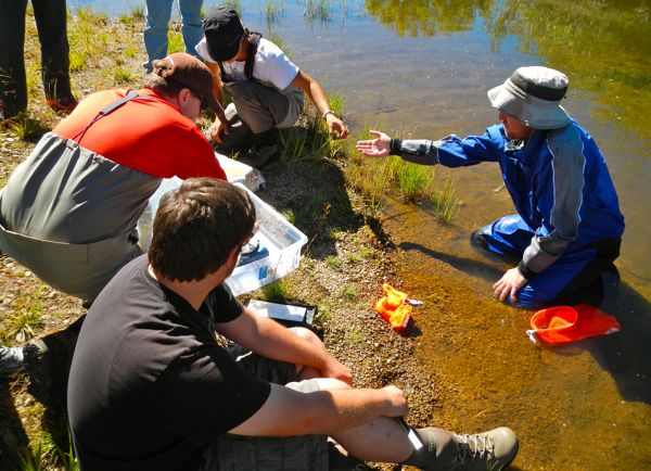
Mason Bindl hovers on the water, splashing a bit as he uses a snorkel and mask to look for these mussels that look big enough to eat. He scoops them into a mesh bag.

On the riverbank are Cody Bear, Phil Meting Van Rijan and Erin Miller. They are recording the particulars about the mussels so as monitoring begins in October, and then continues every three months, officials will know the survival and growth rates.

Working on the project are, clockwise from right, Mason Bindl, Cody Bear, Phil Metting Van Rijan, and Erin Miller.

Working on the project are, clockwise from right, Mason Bindl, Cody Bear, Phil Metting Van Rijan, and Erin Miller.

If they aren’t removed, they all would die. This is because where they are will be drained in 2016 and then filled in with dirt. A final sweep of the current channel will be made that summer to retrieve any stragglers.

A new 7,000-foot river channel has been in the works for a few years.

Sarah Muskopf, fish biologist with the USFS, said, “It’s important to salvage this population. Not only is it the last one, but it’s a huge part of the ecosystem.”

The creatures, which can live to be 100 years old, are considered filter feeders. This means they feed off the nutrients and contaminants in the water, which in turn helps with clarity.

These native mussels used to be prolific in the Upper Truckee Watershed. Their numbers are diminishing. While scientists don’t know exactly why the decline has occurred, they point to declining habitat for the mussels.

“The habitat is marginal here at best,” Muskopf said.

They prefer cold, clean water with a cobble or gravel floor. That’s exactly what is being designed for the new channel.

Most of the current channel lacks gravel, is warming because it is so shallow and is murky because of all the sediment.

River otters are the mussels’ main predator. When the Lahontan cutthroat trout were in the river this also helped the mussel population grow because they would feed off the excrement.

Besides the Upper Truckee River, these pearlshell mussels are found in the lower Truckee River – beyond the dam in Tahoe City – and in other fresh water bodies in the Western United States.


Man rescued from Lovers Leap

A rock climber had to be plucked from Lovers Leap after having fallen about 20 feet.

The Aug. 31 incident occurred about 12:15pm. Lake Valley fire, El Dorado County search and rescue, CalFire, CHP and CalSTAR assisted in the rescue.

The man, whose name-age-hometown have not been provided, was stabilized by a rope rescue team. He was then placed in a Bauman Bag and hoisted into a California Highway Patrol helicopter. At the Strawberry meadow he was transferred to CalSTAR, which took him to Renown Medical Center in Reno.

— Lake Tahoe News staff report


Incline bike path funding goal met

The Tahoe Fund has met its goal of raising $750,000 in private donations for a bike path from Incline Village to Sand Harbor State Park.

This private investment will trigger more than $12 million from federal, state and local governments.

There are still opportunities to be a part of this effort before construction begins in May. All donations of $100 or more will be featured on a donor wall at the trailhead. Engraved bear and trout shaped pavers are also available along the path for donations of $2,500 and $5,000.

Founded in 2010, the nonprofit Tahoe Fund is dedicated to raising private funds for projects that will improve lake clarity, enhance recreation and inspire environmental stewardship in the Lake Tahoe Basin.

To donate or for more info, emaill info@tahoefund.org or call 775.298.0035.


USFS to remove Incline Lake dam

The U.S. Forest Service Lake Tahoe Basin Management Unit plans to restore wetlands and remove the dam at the site of the former Incline Lake.

The Forest Service purchased the Incline Lake parcel off Mt. Rose Highway in 2009 for its recreation, scenic and natural resource values. During the acquisition process, a site investigation determined that the Incline Lake dam and spillway do not meet federal, state or local standards for a high-hazard dam. The dam is designated as high hazard due to development downstream along Third Creek. The sellers drained Incline Lake prior to completion of the acquisition by the Forest Service, and the lake has not been allowed to refill.

The Forest Service will remove the major dam and spillway and recontour the area to match the surrounding landscape. The minor dam will become a low-water crossing. A variety of techniques will be used to stabilize the area and reestablish wetland vegetation. It will be a 15- to 20-year process to restore the 30-acre area disturbed by the dam to a series of small- to medium-sized ponds, fens and marsh.

The USFS will be working with the community on what to do with the 777-acre site.

Anyone who filed a formal comment on the project has 45 days to file an objection to the decision. For more info, go online.