Calif. leads nation in cycling traffic deaths

By Jerry Hirsch, Los Angeles Times

If you are going to be killed by a car while riding a bicycle, there’s a good chance you are male, older than 20 and living in California or Florida.

That’s the finding of a report issued Monday by the Governors Highway Safety Association that also noted that between 2010 and 2012, U.S. bicyclist deaths increased by 16 percent.

California, with 338 cyclists killed in collisions with motor vehicles, and Florida, with 329, had the highest totals during that period, the report said.

They also had the largest increases in annual cyclist traffic fatalities from 2010 to 2012. Florida’s deaths rose by 37 to 120 in 2012 while cyclist traffic fatalities in California rose by 23 to 123. California had the most bicyclists killed of any state in 2012.

Nationally, cyclist traffic deaths jumped from 621 in 2010 to 680 in 2011 and 722 in 2012. The 16 percent increase was far greater than other motor vehicle fatalities, which rose by just 1 percent during this same time period.
Read the whole story


Series of Tahoe controlled burns to be lighted

The North Lake Tahoe Fire Protection District, Nevada Division of Forestry and the U.S. Forest Service will conduct prescribed fire operations in the Incline Village, Ponderosa Ranch, Tunnel Creek trailhead areas and on scattered urban lots around the Lake Tahoe Basin beginning Nov. 2 and continuing as conditions allow.

Smoke from prescribed fire operations is normal and may continue for several days after an ignition depending on the project size.

Before prescribed fire operations are conducted, the agencies post road signs around areas affected by prescribed fire, send email notifications and update the local fire information line at 530.543.2600, ext. 6. To receive prescribed fire notifications, send an email to pa_ltbmu@fs.fed.us.

Project Information:

· HRP (Worm), various drainages throughout Incline Village, Second Creek Drainage, Wood Creek Drainage, First Creek Drainage (Incline Village General Improvement District), hand piles, 50 acres.

· PRS/Tunnel Creek, Ponderosa Ranch/Tunnel Creek Trailhead, hand piles, 20 acres.

·  West Wood Creek and West Second Creek, Wood Creek Drainage and Second Creek Drainage, understory, 20 to 40 acres.

· Van Sickle Round 10, Lake Tahoe Nevada State Park, Van Sickle Unit south of Kingsbury Grade with access off Vista and Easy Street, hand piles, 186 acres.

·  Tunnel Creek Prescribed Fire, Tunnel Creek drainage, south of Incline Village, understory, 29 acres.


Free wood cutting dates canceled

Free wood cutting in the Wrights Lake Recreation Area of the Eldorado National Forest has been canceled for this weekend because of safety reasons in regards to the forecast of 11 inches of snow in higher elevation.

“Consideration for the safety of the public and our staff is the reason this decision was made,” Richard Thornburgh, district ranger for the Pacific Ranger District, said in a statement. “We are thankful for the help provided by members of the public during last weekend’s event. Approximately 43 cords of wood were removed from the recreation site to provide heat for members of the community.”

The free wood cutting was a way to cleanup after extremely high winds last winter downed more than 200 trees.

It’s possible more dates will be added this fall or next spring.


Edgewood works to keep sediment from Tahoe

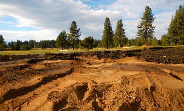
Edgewood Creek is getting an overhaul to improve water quality. Photos/Kathryn Reed

Edgewood Creek is getting an overhaul to improve water quality. Photos/Kathryn Reed

By Kathryn Reed

Playing in the rough has taken on a whole new meaning at Edgewood Tahoe.

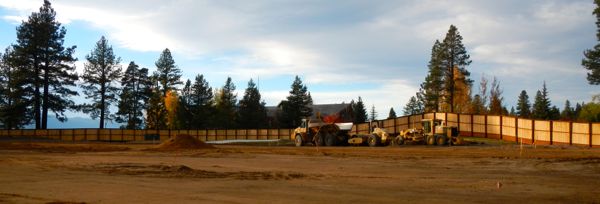
The Stateline golf course looks like a construction zone these days. And that’s because it is one.

By December 2016 the 154-room Edgewood Lodge should be open. There will also be 40 cabin units along the eighth and ninth fairways that will be fractional ownership. The lodge will include a 120-seat restaurant, adventure center, spa, fitness center and lakefront pool.

Right now much of the golf course appears to be more dirt than grass. Work on the lodge will resume in the spring. Work on water quality projects will continue through the winter.

“The best time to perform creek enhancements is during periods of low flow,” Lew Feldman, attorney representing Edgewood Tahoe, told Lake Tahoe News. “It includes increased storage capacity of ponds that act as a catchment basin and expansion of wetlands. It will occur over this winter period, which from an environmental perspective is the safest time to undertake these enhancements.”

That is the work that can be seen from Highway 50. Mounds of dirt have been piling up.

It is Edgewood Creek that is getting so much attention. It is at the bottom of the 4,000-acre Kingsbury Watershed.

Holes 7, 8, and 9 will be tweaked to accommodate Edgewood Lodge.

Holes 7, 8, and 9 will be tweaked to accommodate Edgewood Lodge. The clubhouse is in the background.

That dirt being taken out of the ponds is called “dredge spoils”. The plan is to keep as much of it as possible on the property to be used for the hotel and golf course hole realignments.

When the project is done it’s estimated that more than 400,000 pounds of sediment will be captured each year, with another 50,000 pounds of fine sediment. This means all those particles will not be reaching Lake Tahoe.

Future dredging will be necessary because sediment will always flow downhill to Edgewood.

Feldman called this the largest private water quality improvement project in the basin’s history.

While he wouldn’t give the exact dollar amount, he said it is costing several million dollars. The project is expected to be finished by spring before the runoff starts.

On the other side of the golf course holes 7, 8 and 9 are being worked on. Nine should be done next year. It will have a lakefront finish. Seven and eight will be finished the following year.


Controlled burns in Van Sickle park

The Tahoe Douglas Zephyr Firefighting Crew will be conducting pile burn operations on the Van Sickle Bi-State Park on Oct 31.

The burn location will be visible from much of the Upper Kingsbury and Stateline areas. The treatment area is between the Gondola fire scar and Edgewood Creek.

Twenty to 30 acres will be burned depending on the weather. The piles will be monitored and burn overnight.


Winter driving tips as storm approaches

Caltrans encourages motorists to be prepared for winter driving conditions, particularly in the snowy Sierra, with the first big winter storm expected to hit Friday and continue into the weekend.

Here are some winter driving tips:

• Check your antifreeze level and make sure it is properly filled and formulated for winter temperatures.

• Check your tire pressure and tread.

• Replace the wiper blades and fill the windshield wiper fluid reservoir; be sure to use a winter formula to help de-ice windshields.

• Carry tire chains that are the correct size for your tires, in good working order and practice installing the chains before needing to use them.

• Have a full tank of fuel before traveling.

• Have blankets, extra clothing, food and water, towels, a shovel, a flashlight, an ice scraper, a small bag of sand or kitty litter and road flares.

• When traveling with children, carry small activity packs for them to help prevent driver distractions.

• Have a fully charged cell phone before leaving and carry a car charger.

• Reduce speeds during winter weather and allow for additional stopping time.

• Turn on headlights to see and be seen.

• Turn off cruise control.

• Avoid quick starts, stops and fast turns. Accelerate, brake and steer smoothly and gradually.

• Keep additional distance from other vehicles.

• Watch carefully for snow removal equipment and don’t crowd the plow. Only pass snow removal vehicles when a safe, legal passing area is available and sight distance is good.

• Use extra caution on bridges, ramps, overpasses and shaded areas; they may freeze first.

• If your vehicle begins to skid, steer in the direction of slide and slowly remove your foot from accelerator.

• Understand that winter weather and road conditions can change rapidly and allow for extra travel time.

• Make sure you share the route you intend to take with friends or family.


USFS seeks comments on Taylor-Tallac project

The U.S. Forest Service is asking for public input on plans to restore the Taylor and Tallac creek ecosystems, while maintaining or improving visitor services.

Located on Highway 89 on the South Shore, the Taylor-Tallac project area includes some of the most heavily visited recreation sites in the Lake Tahoe Basin. Baldwin Beach serves an estimated 2.5 million visitors each summer.

The area also provides habitat for numerous protected wildlife species and an important hydrological connection to Lake Tahoe.

Taylor and Tallac channels were historically connected through a series of four swales, which formed a large wetland complex. The Forest Service proposes to restore this connection by removing culverts that are impeding water flow and replacing them with crossing structures, and by recontouring and revegetating swales.

The project would include stream restoration in Taylor and Tallac creeks, such as renovating the fish ladder at the Fallen Leaf Lake Dam to support potential Lahontan cutthroat trout recovery actions, removing portions of the Lucky Baldwin Dam to restore connectivity between Fallen Leaf Lake and Fallen Leaf Dam, and modifying flow releases at Fallen Leaf Lake Dam.

The project proposes to improve wildlife habitat by eradicating or controlling aquatic invasive species, protecting Tahoe yellow cress through physical barriers, installing nest and perch structures for waterfowl and sensitive raptors, placing bat boxes and planting willows for willow flycatcher.

At Baldwin Beach, the Forest Service proposes to construct pedestrian pathways, formalize and upgrade the picnic area (including a pavilion or similar structure), provide foot-washing stations at restrooms and install water quality best management practices throughout the site.

Restoration efforts at Taylor Creek Visitor Center would include upgrading the stream profile chamber building to meet contemporary building codes and provide a more natural aquatic habitat and reconfiguring the Rainbow Trail to reduce impacts to the stream environment zone, such as by raising sections of trail or replacing them with boardwalks.

Comments on the project are due Dec. 5. The project is in the scoping phase of National Environmental Policy Act review.

For more info, go online or contact Sarah Muskopf at 530.543.2835 or smuskopf@fs.fed.us.


Beavers may be good where drought looms

By Jim Robbins, New York Times

BUTTE, Mont. — Once routinely trapped and shot as varmints, their dams obliterated by dynamite and bulldozers, beavers are getting new respect these days. Across the West, they are being welcomed into the landscape as a defense against the withering effects of a warmer and drier climate.

Beaver dams, it turns out, have beneficial effects that can’t easily be replicated in other ways. They raise the water table alongside a stream, aiding the growth of trees and plants that stabilize the banks and prevent erosion. They improve fish and wildlife habitat and promote new, rich soil.

And perhaps most important in the West, beaver dams do what all dams do: hold back water that would otherwise drain away.

“People realize that if we don’t have a way to store water that’s not so expensive, we’re going to be up a creek, a dry creek,” said Jeff Burrell, a scientist with the Wildlife Conservation Society in Bozeman, Mont. “We’ve lost a lot with beavers not on the landscape.”

For thousands of years, beavers, which numbered in the tens of millions in North America, were an integral part of the hydrological system. “The valleys were filled with dams, as many as one every hundred yards,” Mr. Burrell said. “They were pretty much continuous wetlands.”

Read the whole story


Winter storm headed for Tahoe

It may be hard to tell what the Halloween costumes are on Friday night unless a coat is part of the ensemble.

This is because winter is forecast to arrive at lake level. Rain will start the afternoon of Oct. 31, with it turning to snow. By Saturday the snow level is expected to drop to 4,500 feet.

Wind gusts of 35 to 50 mph could create hazardous driving conditions. For current road conditions, click on the state icons on the home page of Lake Tahoe News.

— Lake Tahoe News staff report


Prescribed fires to be ignited in basin

The U.S. Forest Service Lake Tahoe Basin Management Unit will continue prescribed fire operations in the Christmas Valley, Spooner, Heavenly, Elizabeth Lane (Hurricane Bay on the West Shore) and Sawmill Pond areas Oct. 29 and continuing as conditions allow.

Each operation follows a prescribed fire burn plan, which considers temperature, humidity, wind, moisture of the vegetation, and conditions for the dispersal of smoke.

Smoke from prescribed fire operations is normal and may continue for several days after an ignition depending on the project size.

Forest Service staff post road signs around areas affected by prescribed fire, send email notifications and update the local fire information line at 530.543.2600, ext. 6. To receive prescribed fire notifications, send an email to pa_ltbmu@fs.fed.us.