Recreationists lack transit options in Tahoe

By Jessie Marchesseau

This summer the Tahoe Rim Trail Association led the Connecting Tahoe Rim Trail Users to Transportation Alternatives project to study who was using the trail, what mode of transportation they used to get there, whether or not they were using two vehicles as shuttles (which equals even more miles driven) and whether or not they would use transit if it were available.

Results showed 86 percent of hikers arrived by car, 34 percent drove two vehicles in order to self-shuttle, and 59 percent indicated they would consider using transit if it were available. The project went on to examine what transit is currently available, what other communities are doing with similar situations, the alternatives going forward and finally made recommendations as to future transit policies and projects.

Mary Bennington, TRTA executive director, was pleased to announce that since they completed the study, transit stops have already been established in both directions at the Spooner Summit trailheads. The TRTA is also working on creating a TRT app that would help hikers plan and arrange trail access.

Public transit, specifically as it relates to people getting to trailheads, was the subject of the Oct. 21 Tahoe Talks Brown Bag Lunch Series put on by the Tahoe Metropolitan Planning Organization at Lake Tahoe Community College.

The series is designed as a lunchtime forum for residents to learn about and discuss topics affecting the community such as transportation, the environment and economic issues.
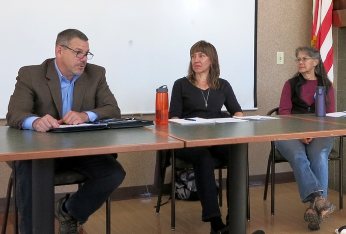
George Fink, Anjanette Hoefer, and Mary Bennington talk Oct. 21 about transit in Tahoe for recreationists. Photo/Jessie Marchesseau

George Fink, Anjanette Hoefer, and Mary Bennington talk Oct. 21 about transit in Lake Tahoe for those accessing trails. Photo/Jessie Marchesseau

This month’s Tahoe Talk was the first in a two-part series to be continued Nov. 18. The speaker panel consisted of Bennington; George Fink, transit system program manager for Tahoe Transportation District; and Anjanette Hoefer, supervisory civil engineer with the U.S. Forest Service. David Reichel, wilderness education coordinator for LTCC, acted as the moderator.

Bennington echoed what the other two panelists had said before her: there is a lot of opportunity here for public and private shuttle services.

Fink focused his short presentation on the importance of public transit and the need for it here in Lake Tahoe, in addition to the need for some changes to our existing system, such as a way for buses to transport more bicycles since an increasing number of riders are bringing their bikes along. (TTD is considering purchasing bike trailers to pull behind the smaller buses). He also discussed issues with transportation funding. Getting dollars for transit is difficult in general, but there are a number of circumstances at work in Tahoe which make it even harder.

Government money for transit is unpredictable, at best, and unquestionably inadequate. There are federal, state and local taxes allocated to transit uses, but they don’t add up to enough to make significant improvements to systems nationwide, and definitely not here in Tahoe.

Tahoe is unique in its transit needs for a number of reasons: first of all, the basin is located in two states, five counties and one city. No individual jurisdiction wants to pay for the transit services in other counties, and California doesn’t want to pay for transit in Nevada and vice versa. This makes funding public transportation from one side of the lake to the other complicated as it crosses so many boundary lines.

Another issue unique to Lake Tahoe is the huge lake right in the middle of the community. There is no central area or hub where everything disperses from like there is in Mammoth, Park City or Breckenridge. Recreation opportunities are located all along the highway that encircles the lake. As a result, adequate transportation to trailheads and recreation areas requires covering a lot more miles.

And finally, there is the issue of only about 50,000 people living in the Lake Tahoe Basin and somewhere in the neighborhood of 400,000 using the facilities. Tourism drives the local economy, but most tourists are not residents. Therefore a lot of the people using the roads and transportation services are not paying into county funds used to finance them.

But, Hoefer pointed out, not all transportation has to be provided by government services. Offering shuttles to and from popular trailheads could be a commercial opportunity for local businesses. She said the Forest Service is looking into creating some sort of permitting system for such services between its trailheads.

“With the public transportation, as you can see, there’s limited funding,” Hoefer said. “We can’t get people from everyplace within the basin to the trailheads they want to be. And there’s an opportunity for commercial providers to provide that, and we want to help work on ‘what does that look like, and how do we do it?’”

The floor was also opened to the 30 or so people in attendance to ask questions and share ideas. Some of the other suggestions/topics touched on included a shuttle to Echo Summit and/or Echo Lake, a Fallen Leaf Lake shuttle, a scenic bus or trolley tour encouraging tourists to ride rather than drive all the way around the lake, a ferry system, how to inform tourists of public transit opportunities, what to do about parking lots for people riding these shuttles, how to get more bikes on buses, and possible ways to get money for implementing any of these ideas.

There is also another side of the issue to consider: would public transit and easy access to trailheads cause overuse of certain areas and trails, ultimately damaging the forests and environment in the long run? It’s a question which can only be answered when and if any of this actually comes to fruition.

Part 2 of the Tahoe Talks Brown Bag Lunch Series on Transit: What’s in Store for Transit North and South? will be Nov. 18, noon-1:30pm in the Aspen Room at LTCC.


Parking for backcountry users being addressed

The Tahoe Regional Planning Agency, El Dorado County, and members of Tahoe Backcountry Alliance are partnering to create a coalition to maintain and enhance public access for winter backcountry skiing and snowboarding.

Nearly a dozen agencies are convening this week to begin a comprehensive conversation about roadside access to some of Tahoe’s more important backcountry skiing locations.


While backcountry skiing has been growing in popularity, parking and access to popular peaks have become increasingly challenging. That issue surfaced this month when a Caltrans project to reduce soil erosion and stormwater pollution on seven miles of Highway 89 between Emerald Bay and Meeks Bay displaced some on- and off-road parking used by the backcountry skiers.

To make up for that lost parking, TRPA and Caltrans approved a project revision to install a 25-by-180-foot paved pullout just south of D.L. Bliss State Park, and California State Parks offered to provide plowed winter parking at the D.L. Bliss State Park Visitor Center.

TRPA said it will review upcoming water quality improvement projects around Emerald Bay that Caltrans has already received permits for to ensure that maintaining or enhancing parking areas for backcountry access is considered in those highway plans.


Lessons learned from an aborted TRT hike

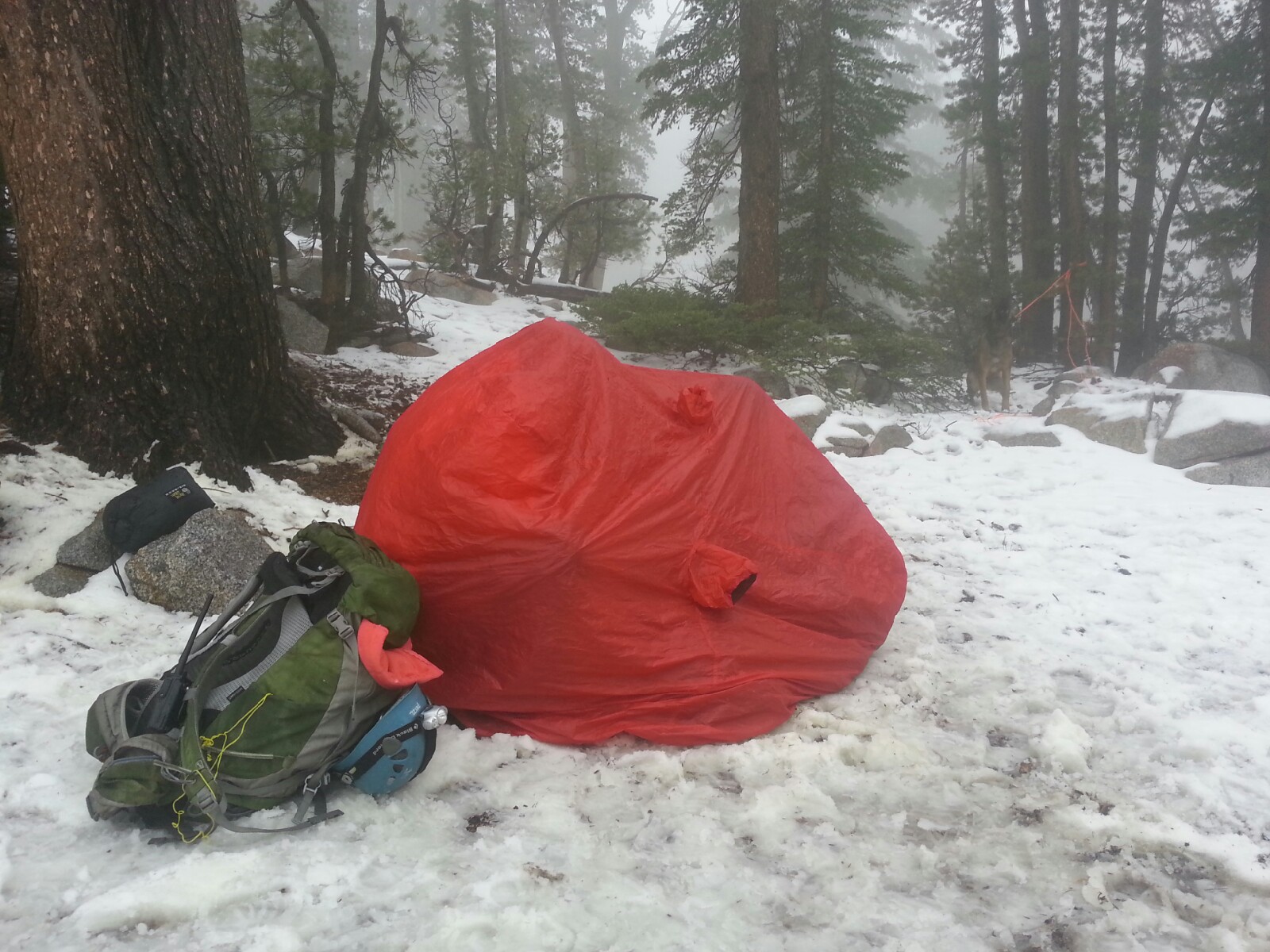
A bothy bag shelter is used to warm someone and get them in dry clothes.  Photo/Provided

A bothy bag shelter is used to warm someone and get them in dry clothes. Photo/Provided

By Michelle Foster

I learned three valuable lessons on my Tahoe Rim Trail through hike.

1. Always through-hike with a partner.

2. Field-test my gear before taking it on a multi-day hike.

3. Take the advice of seasoned explorers.

Letti and I were 30 miles into our planned 165-mile through-hike around Lake Tahoe when we found ourselves in a very dangerous situation.

On Oct. 2, we spotted a mountain lion five miles into our hike on the first day. Early in the morning on the second day, very close to our camp spot, we discovered fresh lion tracks. At this point we were 20 miles from our starting point. It may have been a different lion, but my hike became worrisome and I could not enjoy myself thinking about the lion attacking Letti. Likely, she was his target.

About 29 miles into the hike on the second day, I decided to end the hike the following day. My mind was consumed with the thought of the lion. I was no longer enjoying myself. A mile or so later at around 4pm, I found a great camp spot. It was 10 miles from town in one direction and seven miles the other. An open field close to a cliff with tall trees and flat ground, it was beautiful. The sun was shining. It was warm and windy.

I had cell phone reception at my chosen camp spot, so I called the hotel and changed my reservation. Originally, we were going to be hiking until the 10th. The next day, I planned to hike out to the Big Meadow trailhead seven miles away. From there I would get a ride back to my car. After setting up camp I checked the weather and discovered that thunderstorms and rain were in the forecast from 8pm to 6am. It was close to sunset, and the next possible camp spot was about two miles away. By the time I packed up camp and moved it would be dark.

Mistake No. 1, I decided to stay at my current camp at 9,400 feet.

By 7pm, I was comfy in the hammock and Letti was sleeping underneath.

Mistake No. 2, she started to shiver so I put my down jacket on her. I put her arms through the armholes and zipped it up around her. It fit her really well.

The storm arrived right on schedule. At 8pm the winds picked up and it started snowing, raining and hailing. Hard. At one point during the start of the storm Letti ran off and came back without my jacket. My only other jacket was a thin rain jacket.

One thing I was not aware of is that you need a blanket or sleeping pad to go between you and the hammock. My sleeping bag was not enough and I was cold (because of the wind whipping under). But, I was able to keep semi-warm.

Mistake No. 3 was using the hammock. My boyfriend, a very experienced outdoorsmen, advised against it. In fact, he recommended I bring a tent. I did not listen and decided to go with only the hammock. The hammock is supposed to go over you like a bivy, protecting you from the rain or snow. At about midnight I realized the snow had been getting in the hammock and I was completely submerged in water. By this time the storm had picked up significantly. The wind stung the exposed skin on my face and hands. The sky continued to pelt out an unwelcome mixture of snow and rain. I knew that being cold and wet was not good.

I rolled out of the hammock and found a spot in the snow to laydown. It was so cold. I was soaking wet. I could not stop shivering. I brought Letti in with me, moved around but nothing would keep me warm. I finally let Letti out of the bag because she started to shiver and she was freezing. She got out and started running around playing in the snow. I made the plan to keep moving inside the bag until the sun came up, at which point the storm was supposed to end. I would quickly pack our stuff and hike the seven plus miles out. Until then, I knew I had to keep moving. I moved around inside the bag, did push-ups and planks for the next five hours to keep warm.

The fourth and most important mistake I made was to not take my situation seriously, as the other three mistakes were occurring. I waited so long to do something that by the time I did, I was too weak to do anything about it. I should have taken action immediately. Especially after I got soaking wet at midnight in the middle of the storm.

At 5am on Oct. 4, I was exhausted and still unable to stop the shivering. Every time I tried to leave the shelter of the bag, I would convulse and shiver worse. I thought about hiking out and knew it was going to be difficult, possibly very dangerous. Another storm was supposed to roll through at 8am. It would take me four hours to hike out, possibly more in the snow. In the condition I was in, I did not think it was safe to hike out soaking wet and exhausted only to get caught in another storm with no shelter. I also knew I could not stay there. It was too cold, exposed to wind and I was beginning to feel very sleepy … my body was giving up. This scared the crap out of me. So I called for help.

I called 911, and spoke to two different gentlemen on the phone. They asked me about my situation and asked if I needed help. “Yes, please!” Thank goodness I had my Garmin GPS with me. I was able to give 911 my exact location. The GPS had been a handy tool as I was planning the hike. I marked every water source, camp spot and possible exit route, now it was helping to give the rescuers my location.

The sheriff’s office told me that the El Dorado Sheriff Search and Rescue would be calling me and to charge my phone if I could. Shortly after Jo, the El Dorado Sheriff Search and Rescue incident commander called me. She told me to get out of my wet bag and walk around and make a fire. I told her I could not make a fire because everything was wet, and I could not leave the shelter of the bag because of how cold I was. All I could do was sit in a huddled position and rock back and forth for heat. Jo told me to eat, drink some water and move inside the bag. She called me a couple of times to check on me and give me updates. It was really awesome knowing help was coming.

The search and rescue team arrived about five hours after first contact. Two women from the team immediately put me into a pop-up shelter and inside a warm, dry sleeping bag.

They helped me take off my wet clothes (I had a difficult time moving my fingers and hands) and put warm clothes on me. They then placed Nalgene bottles filled with hot water inside the sleeping bag. After I was warmed up, they gave me hot chocolate and a muffin. Those women were awesome. They asked if I could hike down, that they had special access to a route that was about an hour and a half away. Finally warm and knowing the trailhead was close I had the motivation I needed. I knew, I could hike out.

I left the pop-up shelter to find that the other half of the SAR team had packed up my stuff and were prepared to carry it out. The hike out was sloshy, cold, and mostly downhill. My body and feet were very sore, my hands were not cooperating, but I kept moving and talking to the team. Letti really enjoyed the hike out. There was a handsome Shepard search dog that she played with most of the hike out. She did not have to worry about her pack, because they carried it for her.

At the trailhead a sheriff’s deputy was waiting to take me to an ambulance.

The paramedics took my vitals and checked my feet. Everything was normal. They asked me if wanted to go to the doctor and I said no. All I wanted to do was get to my hotel, take a hot shower, eat an entire pizza, and pass out. Spending several hours at a hospital sounded horrible.

I thanked the SAR team, and I got to meet Jo. The search team said she is like the mother of the team. A tough-ass-woman who knows her stuff. She was a light in the darkness on the phone. A great incident commander.

From there, a deputy drove me to my car about a half an hour away. Upon arrival to the Spooner Summit parking lot, I was shocked to discover that my car had been broken into. Thieves busted out my back passenger window and took my purse and overnight bag with all my clean clothes and shower stuff.

The deputy could not file the report because he was from California and my car was parked in Nevada. While waiting for the Nevada police to arrive, the sheriff was kind enough to share his lunch with me. Refreshing Gatorade and the best pizza I have eaten in my life.

The Nevada policeman took my statement and told me that he wished I had contacted the police department before parking my car at Spooner Summit. He said that two or three car thefts happen in that area a week from people who are out of town and through-hiking on the Tahoe Rim Trail.

After filing the police report, I went to Wal-Mart to buy clean dry clothes, a toothbrush, and duct tape so that I could tape up the window. No places were open to fix the window, so I decided to drive back to Salt Lake City and have it fixed at my dealership.

That night, I slept deeply for over 12 hours in the hotel room. During the eight-hour drive home, I had a lot of time to think about what I had experienced. I cried, laughed, and I was overwhelming thankful to be alive.

I realized the most important thing I did right during my survival experience. Bringing Letti. A smart, athletic, 16 month-old Belgian Malinios, she knew staying in the wet sleeping bag was a bad idea. She fought to get out and run around to stay warm. I tried to force her to stay in the bag with me, but I realized she was getting too cold, which made me realize I could not just lay in the bag. I had to move inside the bag. I worried about her all night. I heard her circling around my bag growling and barking at the night. The thought of her condition and what she was doing kept me from falling asleep when my body wanted to give up. When she heard the SAR team coming her bark echoed through the mountains, alerting the team to my location. Letti saved my life.

I am forever grateful to the El Dorado Sheriff Search and Rescue team for rescuing me, from myself that day.

I am home now. Warm, safe and very happy to be alive. Letti is doing very good – her normal hyper-happy self. She is getting extra love, snacks and attention from me. She totally deserves it.

I plan to continue my hike around the Tahoe Rim next summer with a trusted hiking partner, field-tested gear, and an extra pair of clothing. But most important, I will be armed with the knowledge and experience needed to recognize when I am in a dangerous situation and to react immediately.


Deadline to get USFS wood approaching

The last day to purchase a U.S. Forest Service fuelwood permit is Nov. 13 and the last day to cut wood is Nov. 15.

Permits cost $20 per cord, with a two-cord minimum purchase and a limit of 10 cords per household.  Permits have specific conditions and complete information is provided when the permit is issued. Maps to designated cutting areas are provided and must be in the permit holder’s possession along with the valid permit.

Forest roads and gates begin closing in late October for soil protection and public safety. Some cutting areas may not be accessible by vehicle in areas where gates have closed.

For specific forest road closure dates, go online.


For more information, call the South Shore office at 530.543.2694 or the North Shore office at 775.831.0914.


Christmas Valley controlled burns to last for weeks

The U.S. Forest Service Lake Tahoe Basin Management Unit will begin prescribed fire operations this weekend in Christmas Valley.

Operations may take place near Grass Lake Road off Highway 89 beginning today and may continue for the next several weeks as conditions allow.

Smoke from prescribed fire operations is normal and may continue for several days after an ignition depending on the project size and environmental conditions.

Before prescribed fire operations are conducted, agencies post road signs around areas affected by prescribed fire, send email notifications and update the local fire information line at 530.543.2816.


CDFW to set up checkpoints on I-80 in Truckee

The California Department of Fish and Wildlife will be conducting wildlife checkpoints in Truckee to promote safety, education and compliance with laws and regulations.

Wildlife officers will be at the agriculture inspection station on westbound Interstate 80 from 8am-4pm on Oct. 18, Nov. 14 and Nov. 22.

Officials say wildlife checkpoints encourage safety and sportsmanship by promoting voluntary compliance with laws and regulations through education, preventative patrol and enforcement.

All anglers and hunters will be required to stop and submit to an inspection. CDFW officers will also be providing informative literature about the invasive quagga mussel to anglers and chronic wasting disease to deer hunters.


Coroner stirs debate on mandating ski helmets

By Brandon Barrett, Pique

A coroner has called on the province to consider making snow-sport helmets mandatory at all British Columbia ski hills following the conclusion of an investigation into the 2013 death of a teenaged snowboarder on Grouse Mountain.

“The research reviewed during the course of this investigation indicates helmets can reduce the risk of serious injury in certain scenarios,” Coroner Timothy Wiles wrote in his report. “However, there are currently no regulations mandating helmet use in the Province of British Columbia.”

Whistler Blackcomb declined to be interviewed in the topic, but sent a statement from safety manager Kira Cailes.

“Whistler Blackcomb recommends the use of helmets to all guests. As for making helmet usage mandatory at B.C. ski resorts through legislation, we believe that encouraging safe skiing and boarding practices through education, awareness and example is a more effective approach to limiting head injuries.”

The coroner’s recommendations flow from an investigation into the death of 16-year-old exchange student Luca Cesar, who was snowboarding at the North Vancouver resort on Nov. 29, 2013, when he became separated from his friends.

Read the whole story


Eldorado Forest to resume fire restrictions

An extended forecast of dry weather and concern expressed by the public in the aftermath of the Butte Fire have prompted Eldorado National Forest to put fire restrictions back into effect beginning Oct. 16.

Fire restrictions for recreational use will not affect the forest prescribed fire program.

Campfires will still be allowed in some developed recreation sites. These sites are listed online.

For more information on camping and other recreational opportunities, call 530.622.5061.


Playing daily fantasy sports not the best bet

By Drew Harwell, Washington Post

After sitting through your 30th DraftKings or FanDuel commercial of the day — Scott H. won $15,000 off a $5 bet! — you may find yourself thinking: Maybe I should try my hand at daily fantasy sports. It’s like that fantasy-football league at work, just sped up a little, right? How hard could it be?

The game, as the ads say, is straightforward: A bettor pays an entry fee (between 25 cents and about $5,000), joins one of the site’s many contests and then starts crafting a fantasy team, by choosing professional athletes (each with a price; the team can’t go over a “salary cap”) and then getting scored on how well they play on the real-life field.

DraftKings and FanDuel’s betting ranks have exploded: Even after a week of controversy, the two sites’ guaranteed-prize games just pulled in more than $45 million in entry fees, their biggest Sunday of this National Football League season, according to industry tracker SuperLobby. But beyond its simple concept, daily-fantasy gameplay is loaded with quirks, risks and hidden pitfalls that critics say can stack the deck for veterans and lead casual players to lose out.

Read the whole story


Control burning near Tahoe City set to start

California State Parks will begin prescribed fire operations this week near Tahoe City. Operations will take place in Burton Creek State Park beginning Oct. 15 and will continue over the next several weeks as conditions allow.

Fall and winter bring cooler temperatures and precipitation, which favor prescribed burning.  Each prescribed fire operation follows a prescribed fire burn plan, which considers temperature, humidity, wind, moisture of the vegetation, and conditions for the dispersal of smoke.  This information is used to decide when and where to burn.

Smoke from prescribed fire operations is normal and may continue for several days after an ignition depending on the project size and environmental conditions.

Before prescribed fire operations are conducted, agencies post road signs around areas affected by prescribed fire, send email notifications and update the local fire information line at 530.543.2816.