What Calif. can learn from how the South manages wildfires

The Marina Fire near Mono Lake is one of several currently burning in California. Photo Copyright 2016 Carolyn E. Wright

The Marina Fire near Mono Lake is one of several currently burning in California. Photo Copyright 2016 Carolyn E. Wright

By Laura Bliss, CityLab

There are three things that give him joy in life, says Johnny Stowe: “Beer, my grandkids, and fire.”

Not a campsite fire, or a house fire, but fire that Stowe prescribes and manages across the wild lands of South Carolina. As a heritage-preserve manager for the state’s department of natural resources, Stowe works with crews to set ablaze predetermined swathes of land around the state, carefully burning off undergrowth with low-intensity flames along carefully planned control lines. Every year, in winter and spring, on days when the weather and wind are just right, Stowe lights up thousands of acres this way. He loves every minute of it.

Each year, according to the U.S. Forest Service, roughly 8 million acres of land are treated with prescribed fire in the Southeast—more than in all other U.S. regions combined.

A chorus of ecologists is calling on more of the U.S. to emulate the Southeast’s fire-friendly ways—especially California, where catastrophic wildfires over recent summers have captured national attention. This year, the state’s wildfire season arrived earlier than ever, and with a vengeance.

Read the whole story


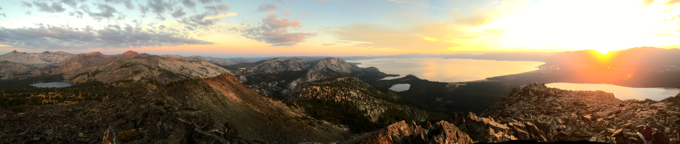
LTBMU sets course for next 15 years

By Kathryn Reed

While most people won’t notice any changes to the forest in the Lake Tahoe Basin, those who are responsible for the care of its resources have a keener eye on the impacts of climate change and are considering stronger oversight of its waterways.

It had been 28 years since the Lake Tahoe Basin Management Unit last updated its Land Management Plan. Litigation at the federal level that was not related to Tahoe stalled the plan that was started 12 years ago and was just approved in late June.

tahoe wilderness

Lake Tahoe Basin Management Unit contains 155,000 acres. Photo/Kathryn Reed

The bulk of the current plan has been in the process since 2012, with multiple meetings surrounding it, and the public’s ability to give input and direct the outcome throughout the last four years. This document is intended to be valid for 15 years.

“The average visitor or resident won’t see much difference. Partially that is because the 1988 plan set the LTBMU on a good course of restoration, forest health and balanced and diverse recreation offerings,” Mike LeFevre, planning staff officer with LTBMU, told Lake Tahoe News. “However, the new plan incorporates a lot of new science around things that really did not exist in 1988 such as climate change and invasive species. For example with climate change, drought and the severity of wildfires we now know we have to increase the pace and scale of our forest management. The new plan describes desired conditions that lead to forests that are resilient to drought, insects and fire.”

Most people in the basin are now accustomed to summer thinning and winter pile burning. That process started in earnest after the destructive 2007 Angora Fire that leveled 254 houses and charred more than 3,000 acres, most of which was U.S. Forest Service land.

Fuels reduction on the 155,000 acres in LTBUM is a big part of the new forest plan.

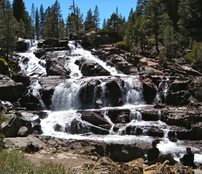
Glen Alpine waterfall on the South Shore is part of the LTBMU's responsibility. Photo/LTN file

Glen Alpine waterfall on the South Shore is part of the LTBMU’s responsibility. Photo/LTN file

The plan divides the region into four management areas — general conservation, backcountry (50,084 acres), wilderness (Desolation, Granite Chief and Mt. Rose) and Santini-Burton/urban forest parcels. The 1988 plan had 21 management areas.

“This plan includes a 3,600-acre area surrounding Stanford Rock on the West Shore in the backcountry management plan,” LeFevre explained. “All of the backcountry management plan will emphasize natural ecological processes, dispersed recreation and limited management. Overall these areas are already managed for a less developed character, but importantly this plan affirms that approach for the life of the plan.”

This plan allows for less developed recreation than the 1988 rules. However, it still calls for an increase. Campgrounds and day-use parking can increase by about 10 percent.

This will help give the already 5.7 million annual visitors more options.

Road and trail systems, and uses remain similar to their current existence.

While the Upper Truckee River does not have the federal Wild and Scenic River System designation, since 1999 seven miles of it has been managed as though it is. This is so if Congress were to consider the designation, the river would have a good chance of making the cut.

The process for the USFS to recommend rivers-streams be included in the Wild and Scenic River System has two steps.

“First step is to determine if the stream is eligible. After reviewing the outstanding attributes of all streams in the LTBMU, the plan identifies three tributaries of the Upper Truckee River and three creeks — Taylor, Glen Alpine, Eagle — as eligible,” LeFevre said. “The second step is to determine if an eligible stream is suitable. The plan does not include an analysis of suitability for the streams found eligible. A suitability study includes a substantial amount of public input and analysis. The LTBMU has no plans at the present to initiate the suitability analysis. However, the plan does direct that the streams found eligible be managed to ensure they remain eligible.”


Nev. ready to boost drone industry to next levels

By Nicole Raz, Las Vegas Review-Journal

Nevada is at the forefront of pushing the national unmanned aircraft system or drone industry forward.

“We view all the UAS test sites as equals,” a Federal Aviation Administration spokesman said. “However, Nevada has one distinction: It’s the only site to have the ability to certify unmanned aircraft as an FAA designated airworthiness representative.”

Nevada’s FAA test site designation is giving state drone-industry players a boost to develop the industry to its limits.

Read the whole story


Climate change could alter Tahoe’s chemistry

By Alexander L. Forrest, The Conversation

In an age of rapid global population growth, demand for safe, clean water is constantly increasing. In 2010 the United States alone used 355 billion gallons of water per day. Most of the available fresh water on Earth’s surface is found in lakes, streams and reservoirs, so these water bodies are critical resources.

As a limnologist, I study lakes and other inland waters. This work is challenging and interesting because every lake is an ecosystem that is biologically, chemically and physically unique. They also are extremely sensitive to changes in regional and global weather and long-term climate patterns.

For these reasons, lakes are often called “sentinels of change.” Like the figurative canary in the coal mine, lakes may experience change to their ecosystem dynamics before we start to see shifts in the greater watersheds around them.

In a study I recently co-authored with Goloka Behari Sahoo, Geoff Schladow, John Reuter, Robert Coats and Michael Dettinger, we projected that future climate change scenarios will significantly alter natural mixing processes in Lake Tahoe in the Sierra Nevada range that are critical to the health of the lake’s ecosystem. This could potentially create a condition that we termed “climatic eutrophication.”

While many groups have studied the long-term impact of climate change on lakes, this process can now be added to the growing list of drivers of eutrophication. This is a potentially damaging phenomenon that could affect a number of vital deep-water lakes around the world, degrading water quality and harming fish populations.

Eutrophication is a condition that occurs when lakes and reservoirs become overfertilized. Cultural eutrophication is a well-understood process in which lake and reservoir ecosystems become overloaded with chemical nutrients, mainly nitrogen and phosphorus. These nutrients come from human activities, including fertilizer runoff from farms and releases from sewage systems and water treatment plants. Natural weathering processes, atmospheric deposition of air pollutants, and erosion also transport nutrients that are already present in the watershed into the water supply.

In water bodies, these heavy nutrient loads fertilize algae, causing surface algal blooms. When the algae die, they sink and are broken down as they decompose. This decomposition process consumes dissolved oxygen in the water. As oxygen levels become depleted, hypoxic (dead) zones develop in the bottom waters where oxygen levels are too low to support life. Dead zones harm fisheries and tourism, and algal blooms can contaminate drinking water.

Over the past several decades, state and federal regulators have developed many initiatives to eliminate or reduce nutrient sources. In some cases, such as Seattle’s Lake Washington, water quality has improved through management. In other, larger watersheds – notably, the Great Lakes – nutrient pollution is still a major problem.

As anyone who has swum in a lake knows, the water is typically warmest on the surface where the sun shines on it. Cold water is denser than warmer water, so it sinks. For much of the year, deep lakes will remain stratified (separated into layers).

In fall and late winter, large storms disrupt natural stratification and cause lake waters to overturn. This mixes surface waters down into the lake’s depths and brings deep water up to the surface, where it can absorb oxygen from the atmosphere. This process, which transfers dissolved oxygen from the surface to the lake bottom, is critical for an ecosystem’s health.

But our study showed that surface warming in Lake Tahoe could cause climatic eutrophication by reducing or even ending mixing, thus interrupting the vertical movement of dissolved oxygen from the lake’s surface to the lake bed.

Scientists, spearheaded by UC Davis, have been monitoring conditions at Lake Tahoe for nearly 50 years, so we have good records of short- and long-term changes in water temperatures and quality. Since 1968, the average temperatures of the lake’s surface waters (down to a depth of 80-120 feet) have increased by nearly 0.5 degrees Celsius. That change has increased the lake’s stability – a measurement of how resistant it is to overturning – enough to reduce the probability that surface waters will mix all the way to the lake bottom.

To model possible future conditions, we estimated Lake Tahoe’s annual stability by combining a lake hydrodynamic model – representing how water is moved around the lake – with two different greenhouse gas emission scenarios published by the Intergovernmental Panel on Climate Change. In one scenario, emissions increased rapidly throughout this century; in the other, emissions leveled off by the year 2100.

Under both scenarios, meteorological conditions influencing the lake are projected to change. Notably, wind speeds would decrease by 7-10 percent, and air temperatures would increase by 2.5-4 degrees Celsius. These warmer, less windy conditions across the lake will extend and magnify the warming and stratification trends that we are already seeing.

As the lake remains stratified for longer periods each year and less overturning occurs, dissolved oxygen levels at the bottom will decline. Under these conditions, nutrients stored in the lake bed will be released to the water through chemical reactions that occur in low-oxygen environments. This new source of nutrients, known as internal loading, will further contribute to the process of climatic eutrophication.

Although all lakes are unique ecosystems, this process could also occur in other deep-lake settings around the world, such as Japan’s Lake Biwa or Lake Baikal in southeastern Siberia. Climate change is already shortening the periods each year when many temperate and polar lakes are covered with ice. As water temperatures rise in the upper layers of deep lakes, they will remain stratified for more of the year and will be less subject to mixing. Less dissolved oxygen will be returned to deep waters, which will stress fish populations.

And unlike cultural eutrophication, climatic eutrophication could affect entire watersheds or regions, since it is driven by climatic influences rather than by discharges of nutrients into a lake from farms or cities.

Climatic eutrophication has serious implications for long-term water supplies and aquatic ecosystem health around the world. To recognize and track it, we need to identify lakes in North America and around the world that could be at high risk.

In areas where scientists and regulators are working to reduce conventional eutrophication, these experts will also need to factor the possibility of climate-forced eutrophication into their strategies. The first step is to support more monitoring of lakes’ physics and chemistry so that we can recognize, track and predict climatic eutrophication of our lakes and reservoirs.

Alexander L. Forrest is an assistant professor of environmental engineering at UC Davis.


Wildflowers blanket Washoe Meadows Park

A variety of wildflowers grow throughout Washoe Meadows State Park. Photos/Kathryn Reed

A variety of wildflowers grow throughout Washoe Meadows State Park. Photos/Kathryn Reed

By Kathryn Reed

WASHOE MEADOWS STATE PARK – Wildflowers, some no bigger than a pinky nail, are bringing a seasonal splash of color to Washoe Meadows State Park.

washoe meadows wildflower hike“It’s a little past peak season. It changes week by week,” Lisa Berry, California Native Plant Society member, tells the group she is leading on a trek through the park. Even so, she manages to point out 34 flowers in a two-hour outing on the last Sunday of June.

This is the Sierra State Park Foundation’s first wildflower hike. The group’s goal is to bring more people into this park in Meyers.washoe meadows wildflower hike

“My favorite time to come here is in early spring. It’s really special,” Berry said.

Even so, those traipsing through the park on this particular day were thrilled to find such an array of flora. Some are obvious – they are right along the trail. Others are also right on the trail – but not obvious. That was the fascinating thing about the excursion, finding flowers that might otherwise be overlooked.

Berry also used a discovery scope that allowed the group to see the detail of the flowers that isn’t possible with the naked eye. She pointed out the particular elements of the flower, including the reproductive parts.

washoe meadows wildflower hikeTidbits of information were imparted – like how white and pink yarrow are the only colors found in the wild, while the other colors are garden variety; that these wildflowers are not bred to be picked, and would wilt quickly if put in a vase at one’s home; that even edible plants can become poisonous if a parasitized plant brushes against it; the basin has paint brush, but no Indian paint brush – that’s more common in the Carson Pass area; native Americans used camas in their cooking because the bulb is sweet; the self-heal can be used for medicinal purposes; and the woolly mule ear is OK as a substitute for toilet paper in the woods, but corn ear might send you to the doctor.
Some of the flowers that were found on this walk were: star lily, cinquefoil, meadow penstemon, white brodea, Alpine dandelions, dusty horkelia, gillyflower, Sierra Nevada pea, salsify, torres lupine, and caterpillar phacelia.


As firework laws are relaxed, injuries increase

By Janissa Delzo, CNN

Fireworks are synonymous with Fourth of July celebrations. But as entertaining as sparklers, bottle rockets and other consumer items can be, they’re also responsible for many injuries, which can sometimes result in death.

These injuries, particularly burns requiring hospital stays, are especially high among people 20 and younger, according to new research.

As states have relaxed laws related to fireworks sales over the past decade, emergency doctors saw an increase in the number and severity of fireworks-related injuries among young people, the data show.

They determined that the number of patients under age 21 treated and released by emergency departments between 2006 and 2012 rose modestly: from 4.28 per 100,000 people in 2006 to 5.12 in 2012. Significantly larger increases were seen in injuries requiring inpatient hospital admission, which skyrocketed from 29 percent of cases in 2006 to 50 percent in 2012.

Read the whole story


Opinion: Eastern Sierra needs fire regeneration

By Char Miller

Sometimes it’s the small things that can best tell big stories.

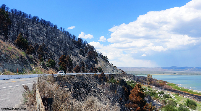
Like the Marina Fire, which has burned a modest 654 acres to the north of Lee Vining, threatened but not burned any structures, and whose greatest disruption was periodically to shut down Highway 395. It hardly seems worth much attention.

Such minor fires in the Eastern Sierra have routinely received little note. Historian Robert Cermak has dubbed the region, home to the Inyo and Humboldt national forests, an “asbestos” terrain. It’s so fireproof that Stephen Pyne, in “California: A Fire Survey” (2016), pays it no mind.

This disregard, along with the Marina Fire’s diminutive size—and lack of headline-grabbing ferocity—is precisely why we should focus it and the lessons it conveys about the critical role fire can play in the Sierra.

The Marina Fire has blackened much a swath of land bordering Highway 395. Photo Copyright 2016 Carolyn E. Wright

The Marina Fire has blackened a swath of land bordering Highway 395. Photo Copyright 2016 Carolyn E. Wright

Start with the reality that many of the Eastern Sierra habitats which the Marina fire slowly worked through—in the official language it was characterized by “smoldering of heavy down fuels”– are similar to the more iconic pine forests on the western slope: fire can fuel their regeneration.

This biological process is also one that humans have helped shape. Ethnobotanist M. Kat Anderson argues in “Tending the Wild” (2005) that California’s first people used fire so routinely and for so long that they created “a carefully tended ‘garden’ that was a result of thousands of years of selective harvesting, tilling, pruning, burning, sowing, weeding, and transplanting.” The vegetation growing on the steep slopes rising above Highway 395 as it curves between the Sierra and Mono Lake may not be quite as “natural” as we assume.

That reality is also why the Marina Fire’s charring force was not destructive but custodial—a clearing away and a cleaning up. Aspen, one of the Eastern Sierra’s signature trees, thrives after fire chews through litter and competing species. The pinyon pine may have a fire-return interval of up to hundreds of years, but one way its younger trees can succeed the older is via fire. It can open the canopy, a flame-driven opportunity that makes the whole forest more vigorous.

Animals can be just as opportunistic. The speedy, post-fire resprouting of sagebrush, rabbit brush, and grass is manna to antelope, deer, sheep and other wildlife that range through the Eastern Sierra. Like domesticated livestock, they are drawn to these tasty greens, a biotic rejuvenation and nutritional boon.

These ecological benefits guided how firefighters have been managing the Marina Fire; which as of today is 95 percent contained. They have established control lines on its northern, southern, and eastern margins to protect communities, structures and Highway 395. Yet they have not suppressed it with fire-retardants because however insignificant the Marina Fire may seem, they know its import. They are stewarding it so that it can steward the land.

Char Miller is W.M. Keck professor of environmental analysis at Pomona College and author of “America’s Great National Forests, Wildernesses and Grasslands” (2016) and the forthcoming “Not So Golden State: Sustainability vs. the California Dream” (2016). This is an updated version of a commentary that first appeared in the Reno Gazette-Journal.


Report: Nev. struggles with teacher absenteeism

By Ian Whitaker, Las Vegas Sun

Nevada’s long-running battle against student truancy is well known, but should we also be concerned about teachers missing class?

According to research by the Education Week Research Center, Nevada has one of the highest rates of teacher absences in the country.

As much as 49 percent of teachers in the Silver State miss 10 or more days during the school year, the second highest number of absences of any state. Hawaii comes in first, with 75 percent of its teachers taking 10 or more days off. The national average is around 25 percent.

Read the whole story


Safety necessary; Tahoe can be deadly

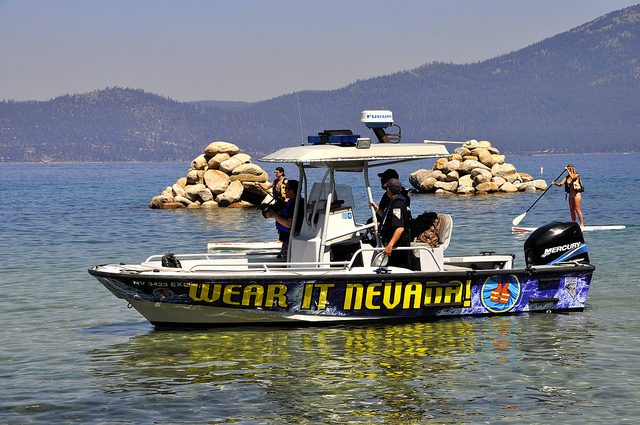
Wearing life jackets is being emphasized b officials at Lake Tahoe. Photo/Provided

The importance of wearing life jackets is being emphasized by officials at Lake Tahoe. Photo/Provided

By Carole Bernardi

INCLINE VILLAGE – Summer at picturesque Lake Tahoe is officially in full swing once the Fourth of July holiday kicks into gear. Boats line the shores, paddleboards compete with kayaks, and swimmers maneuver their way in between.

This year the long holiday weekend presents unlimited opportunities for water activities as healthy snowfall has allowed Lake Tahoe to rise slightly above its natural rim. It’s a recipe for fun, and pending risks.

People often believe hypothermia is the greatest risk of drowning in cold water, but it’s not; it takes hours. In Lake Tahoe, water temperatures can be anywhere between 68-70 degrees by mid-August in the shallower coves. Go down another 4 feet plus and it’s easily 10 degrees cooler. By the time you reach the thermocline (a thin, distinct layer where temperature changes more rapidly with depth than layers above or below) it’s a steady 45 degrees. This degree of shock can kill.

Cold water shock kills in minutes due to an involuntary gasp reflex caused by sudden immersion in cold water. Symptoms are rapid breathing, gasping, fainting, muscle failure, lungs fill with air and an immediate risk of drowning.

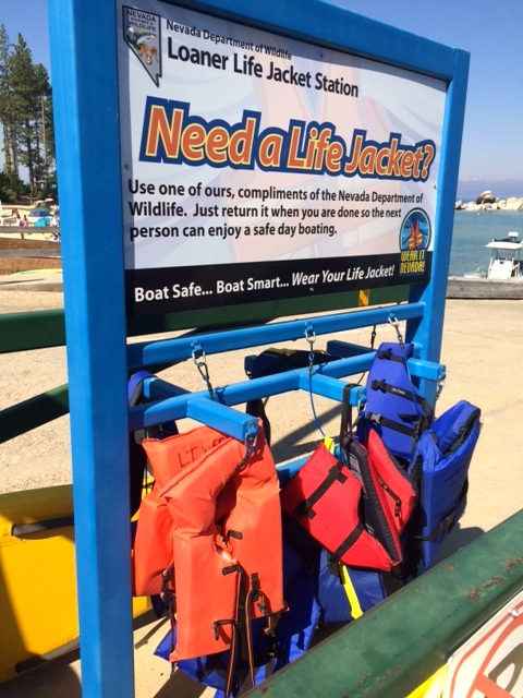
Loaner life jackets are available at Sand Harbor. Photo/Carole Bernardi

Loaner life jackets are available at Sand Harbor. Photo/Carole Bernardi

Officials from multiple state and district agencies (including Coast Guard, sheriff, state park, wildlife and TRPA) are monitoring Lake Tahoe and are bracing for possible fatal accidents during the crowded Fourth of July holiday. They are also out on the lake most other days of the summer.

Water safety is relevant in several situations from boating, paddleboarding, kayaking, Jet Skiing, swimming, diving off a boat or even walking into the lake.

“Your best inoculation against cold water shock is a life jacket. It will save your life,” Edwin Lyngar of the Nevada Department of Wildlife said.

Lyngar has helped spearhead a campaign called Wear it Nevada that unites these agencies in order to impress the importance about life vests. A personal flotation device (PFD) is the most important piece of equipment, so much so that “life jacket loan stations” are now located at Nevada State Parks (15 locations and growing). A grant with the U.S. Coast Guard provides these jackets. One is at Sand Harbor.

Once a life vest is on, there are a few other important tips to consider. Have you adapted to the altitude? Are you drinking plenty of water and staying hydrated? Are you walking into the lake after hours of sun exposure (body temp)? The most obvious for those in a vacation state of mind, what is your alcohol consumption level?

Nevada laws mandate that children 12 and under must wear a life vest, and 13 and older must have one in their possession. Even business owners renting water devices are obligated (insurance liability) to review, with each and every customer, the Coast Guard Navigation Rules and are responsible for providing each customer with a PFD.

“It’s all about team work and everyone’s jurisdiction having the same goal and responsibility to everyone on the water,” said Deputy Rob Buonamici of Douglas County Sheriff’s Department. If a water patrol boat approaches a paddleboarder or kayaker, with no life vest on their body or strapped to their water device, it is a $90 citation.

“Just like a DUI for road violations, a boat operator or person using a water device can be cited for an OUI, which is operating under the influence with an alcohol level of 0.08 percent,” Deputy Ron Skibinski of Douglas County said.

Other tips from the boat patrollers: never swim alone, tell a friend before entering the water, know your swimming limitations, wear a whistle, never jump into cold water, and prepare for accidental immersion by putting on a life vest.


Calif. voters face full plate of initiatives Nov. 8.

By David Siders and Jim Miller, Sacramento Bee

California voters will confront a smorgasbord of policy questions on the November ballot, with initiatives ranging from marijuana legalization and the death penalty to gun control and taxes qualifying by the Thursday deadline.

The Nov. 8 ballot includes the largest number of measures – 17 – since 2000, when 20 measures qualified, according to the California secretary of state’s office. The most all time was in November 1914, when 48 measures appeared.

Only the Legislature can add more measures to the ballot now, and it will have little time to do so after returning from its summer recess in August.

Read the whole story