STPUD, SLT officials embracing renewable energy

Updated April 17:

By Kathryn Reed

South Tahoe Public Utility District’s hydroelectric plant in Alpine County is expected to be online this fall, with power being sold to Liberty Utilities.

The South Lake Tahoe-based water-sewer district had hoped to have the plant operational a few years ago, but money and construction delays pushed the date back. The project is slated to be completed this summer.

Federal law mandates that all wastewater in the Lake Tahoe Basin must be discharged outside the basin. South Tahoe PUD’s treated wastewater goes through a series of pipes over Luther Pass to Harvey Place Reservoir. Then much of the water is distributed to ranchers in the area.
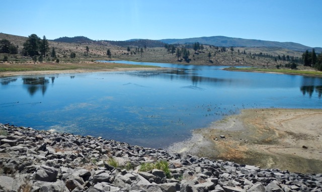
The South Shore’s wastewater ends up in the Harvey Place Reservoir in the Diamond Valley. Photo/LTN file

The utility district bought the old Heise Ranch 12 years ago after farmers started to divvy up their land. Laws require the treated water be sprayed on 100-acre parcels or larger.

The district entered into an agreement this month with Liberty to sell the company some of the electricity that will be generated. The plant is expected to start operating Oct. 1.

“Power will be generated whenever recycled water is not being sprayed through the center pivot rigs onto the Diamond Valley Ranch property (the district owns), so, at least all winter and whenever the alfalfa crops don’t need to be irrigated with recycled water,” Richard Solbrig, general manager of South Tahoe PUD, told Lake Tahoe News. “The district also produces significantly more recycled water than our contracts with all the ranchers guarantee that we will supply to them. Since we have very good working relationships with all the ranchers, there will be active discussions on an annual basis in order to decide the exact amounts and timing for the delivery of recycled water to the six ranchers.”

STPUD estimates that between $25,000 and $30,000 in gross revenues will be generated from the hydroelectric plant.
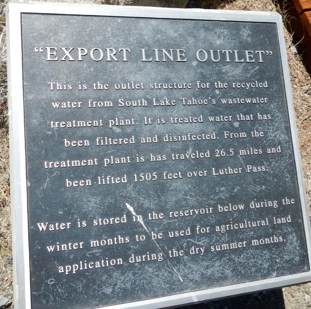
This marker is at the end of South Tahoe PUD’s export line. Photo/LTN file

“With this estimated level of revenue, all costs attributed to the hydropower facilities will be paid for in just over eight years. Life expectancy of the pump and generator are 25 years, while the pressure pipeline itself is expected to last a minimum of 50 years,” Solbrig explained. “The pricing portion of the contract is 10 years, at a unit price established by the CPUC. Buyback price after the first 10 years will be adjusted based upon CPUC review of the value of power at that time.”

In 2015, Gov. Jerry Brown signed a bill mandating that by 2030 state-regulated utilities must get at least 50 percent of their electricity from renewable energy sources, such as wind, solar, and hydro.

This deal will help Liberty achieve that goal.

“This facility is unique because it takes advantage of capturing energy that would have been wasted otherwise,” Travis Johnson, vice president of operations for Liberty, told Lake Tahoe News. 

The city of South Lake Tahoe is contemplating putting even more stringent regulations on Liberty. On the April 18 City Council agenda is a resolution for the city to be using 100 percent renewable energy by 2032. The idea was first brought forward earlier this year by members of the public as the council was working on its strategic goals.

The city is in the process of negotiating its franchise agreement with Liberty. If the council on Tuesday supports the renewable energy initiative, it could then be part of a future contract between the city and Liberty.

“Could Liberty provide the city 100 percent renewable energy in that time frame? Yes, we could. Would it cost more for ratepayers It is possible that it could be more expensive,” Johnson said. “However, two factors come into play: 1) The state already mandates 50 percent renewable by 2030 and 2) Renewable prices continue to fall each year. These two factors will help lower the incremental cost to move to 100 percent.”

He added that wind energy today less expensive than fossil fuels in some regions of the country, with solar getting close.

To prove the city was getting all renewable energy Liberty “would do it by total energy consumed in the region. For easy numbers, if the region consumes 100,000 mega-watt hours per year, we could develop a solar project that produces 100,000 MWh. It is all about putting more renewable energy into the grid.”

A related matter on the council agenda would have the city reduce carbon emissions by 80 percent by 2040.



Vaccination rate jumps in California

By Soumya Karlamangla and Rong-Gong Lin II, Los Angeles Times
 
The vaccination rate for California’s kindergartners soared this fall from the previous year, fueled by a state law that made it significantly tougher for parents to exempt schoolchildren from shots.

It was the highest vaccination rate among kindergartners since at least 1998, and comes after a measles outbreak that began at Disneyland in 2014 focused new attention on the issue.

Data released Wednesday showed that the percentage of California’s kindergartners as of last fall with all required vaccinations rose from 92.8 percent to 95.6 percent.

More kindergartners were also getting the measles vaccination.

Read the whole story


Trump’s budget could kill Amtrak in Truckee, N. Nev.

Passengers get off the Amtrak train in Truckee. Photo/LTN

By Seth A. Richardson, Reno Gazette-Journal 

President Trump’s proposed budget would cut all Amtrak funding for Truckee, Reno, Elko and Winnemucca, possibly ending rail service in Northern Nevada.

Trump’s proposed budget would zero out funding for long-distance rail lines, which are defined as more than 750 miles. Parts of Amtrak’s California Zephyr, which runs from Chicago to San Francisco with stops in Northern Nevada, is among the lines facing cuts.

The president said in his budget book that the long-distance lines “have long been inefficient and incur the vast majority of Amtrak’s operating losses.” The president wants to shift focus to the heavily-traveled Northeast Corridor – most of the eastern seaboard between Boston and Washington – and state-supported lines.

Read the whole story


TTD becoming agent for affordable housing

The environmental document for the loop road is looking at affordable housing going in where these businesses are located. Photo/LTN file

Publisher’s note: This is one in a series of stories about affordable housing in the Lake Tahoe-Truckee region. All articles may be accessed via the home page under Special Projects, 2017 Affordable Housing.

Updated April 15:

By Kathryn Reed

Transit oriented development – it’s the latest buzz phrase in the basin. Simply put, it means creating commercial and residential areas that are walkable-bikeable and have easy access to public transportation.

At today’s Tahoe Transportation District meeting the board will hear a presentation about how housing ties into the proposed loop road project.

The district has identified 78 residential units in South Lake Tahoe that would have to be leveled if and when Highway 50 is rerouted behind Harrah’s and MontBleu. Fifty-five of those units fit the Tahoe Regional Planning Agency’s definition of needing to be deed restricted based on low income criteria. Finding the right mix for the remaining 23 is still in the discussion phase.

TTD has pledged to not have any decrease in housing stock because of the highway project. The bi-state agency has also expressed interest in creating more housing than what it removes.

In the loop road’s environmental document, which will be released this month, three locations were studied for where affordable housing could be located. Affordable in this case goes beyond the legal income based definition.
“When it comes to workforce housing, this is primary housing, and what supports and engages a transit system,” Carl Hasty, TTD chief, told Lake Tahoe News. This would be multi-family housing – apartments, townhomes – no single family residences. And not second homes or vacation rentals.

Hasty has been contacted by three potential developers about affordable housing. But before those projects can be talked about in any seriousness, the highway project needs to have a preferred alternative and be green-lighted.

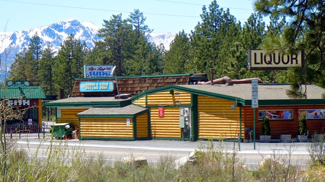
The three areas the environmental impact statement looked at include: the triangle area where the Naked Fish and Bottle Shop are located; directly across the street from there; and the strip of land behind Raley’s at Stateline behind the center and paralleling what would be Highway 50.

This latter area has been talked about by Terry Hackett, the center’s owner, as a potential location for senior housing. Parking could be underneath, with a couple floors of housing above it.

However, Mike McKeen who owns the Naked Fish-Powder House building told Lake Tahoe News, “Low income housing at our property will never happen. I would only be open to condos like the Zalanta project.”

The environmental document is exploring density, commercial floor area constraints and other factors.

Hasty has received a letter of interest by a developer who would like to build 142 units on land that is being studied in the EIS.

“The concept they are suggesting to me is something that we should take a look at,” Hasty said. “I first need a decision about (the highway) project.”

TTD is working with other entities on the housing issue. With TRPA, the city and Douglas County, the plan is to send out a request for proposal seeking “an experienced person or firm to assist the group in addressing housing needs through eligible projects and act as a bridge between the public agencies and the private sector development community.”

Tom Lotshaw, spokesman for Tahoe Regional Planning Agency, told Lake Tahoe News, “Major projects like the proposed Highway 50 project are one place where we can work together to make sure housing improvements are incorporated and a benefit of the final project. These types of transformative transportation projects are a great opportunity to improve not only our transportation system, but to incorporate elements that improve housing options, spur community revitalization and mixed-use redevelopment, and improve the environment.”

Another player in all of this housing talk is the California Tahoe Conservancy. It has several parcels that staff and the board have earmarked to sell. All are located in the Tahoe Valley Area Plan. Here is the CTC land map.

“We are now exploring, among other options, whether we should partner with TTD in soliciting interest from developers to provide housing and/or mixed uses on these parcels,” Patrick Wright, CTC executive director, told Lake Tahoe News.

One area the TTD is eyeing is acreage on Lake Tahoe Boulevard and Tata Lane that CTC owns. Hasty has been approached about a 120-unit development there.

The cost to relocate the displaced residents in the highway realignment project will be incurred by TTD.

—–

Notes:

·      TTD meeting is April 14 at 8:30am, TRPA offices, 128 Market St., Stateline.

·      The Douglas County commissioners will hear a presentation from Hasty on April 20 about TTD’s role in housing and how the county can be a partner.

·      A similar discussion will occur at the May 2 South Lake Tahoe City Council meeting.


Tough trek to gauge California snow

By Brian Melley, AP

We were trudging up the side of a mountain on skis to measure California’s massive snowpack when a late blast of winter stopped us in our tracks.

I started the morning less concerned about strong winds forecast and light snow than keeping pace with veteran snow surveyors in the thin Sierra Nevada air and getting over steep, icy 11,700-foot Kearsarge Pass. Now, shy of that goal, I was struggling to keep warm and stay upright.

 Howling gales warned to brace for impact. It didn’t matter. Gusts bowled me over and toppled Kevin Klinefelter. Staggering to our feet, we followed John Dittli, making turns in a near-whiteout between foxtail pines. Blown downhill to our cars, we decided to return another day.

The arduous work of snow surveyors is largely unknown to most Californians, even as measurements they compiled of a near-record snowpack bolstered Gov. Jerry Brown’s decision to lift an emergency declaration after five years of drought.

Crews stay out as long as two weeks in alpine wilderness, battling the elements, skirting avalanche terrain and plodding through deep powder to gather the data — a practice that has endured even as new technology tries to gauge the state’s expected water supply from snowmelt.

Read the whole story


Golden State has its wettest-ever year

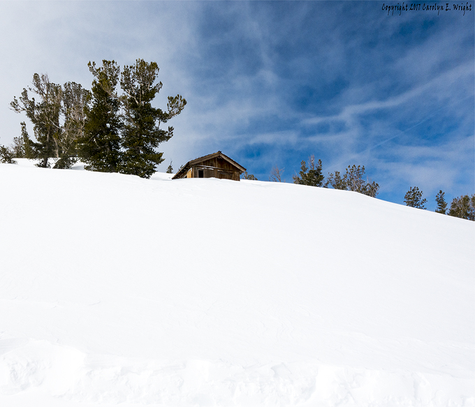
The abundance of snow has made for a great ski season. Photo Copyright 2017 Carolyn E. Wright

By Patrick May, Bay Area News Group

We did it!

With one more soaking-wet storm front dumping its stuff special-delivery over Wednesday night, California woke up on Thursday to a new all-time record for rainfall, as measured in the all-important “Northern Sierra eight-station index,” a catchment area that pretty much defines the Golden State’s water-level health.

“We didn’t just beat the record,” said meteorologist Craig Shoemaker with the National Weather Service in Sacramento. “We shattered it.”

Read the whole story


40 acres of Martis meadow to be rehabbed

By Michael Rohm

Beth Christman, director of Restoration for the Truckee River Watershed Council, knows exactly how small 40 acres is. Compared to the 90,000 acres of degraded watershed within the greater Sierra Nevada region, 30,000 of which are slated to be restored by 2030, 40 acres is a drop in the bucket.

But this is a bucket that has been jostled, kicked and repeatedly drained by 150 years of harmful human impact. Every drop counts.

“We’re doing our part,” she said of her seven-member team at work to maintain and improve watersheds within the Tahoe region. “It all adds up.”

Crews work to restore meadows throughout the Sierra Nevada. Photo/Beth Christman

Christman and her team are one of about two dozen natural resource groups within the greater Sierra Nevada region who have joined forces to create the Sierra Meadows Partnership, a multi-agency initiative to restore 30,000 acres in 15 years. Spearheaded by California Trout, this mixed-bag group of nonprofits, government agencies, universities and funding institutions have come together to restore crucial watersheds that account for more than 60 percent of the developed water supply in California.

For the Truckee River Watershed Council, that restoration began with a crucial 40 acres in the Martis Valley where Highway 267 meets the Middle Martis Creek. This watershed northwest of Lake Tahoe is a salient example of what environmentalists call legacy impacts: the actions of previous generations that affect us today. When the road that would become Highway 267 was first constructed in the 1860s, Martis Creek was channeled to the opposite side of the road, effectively bisecting the floodplain. Subsequent erosion destroyed 40 acres of meadow and contributed to frequent flooding across the highway.

“The infrastructure in that area is not going anywhere,” Christman said. “So we had to get creative to work around the legacy impacts.”

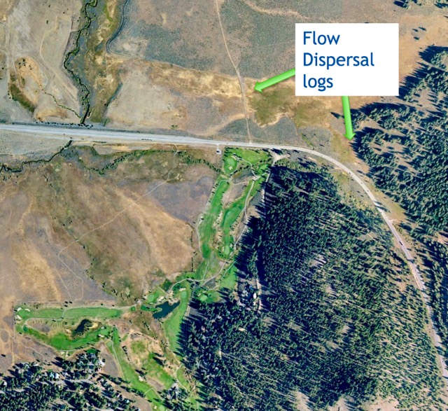
Creative action for Christman and the Truckee River Watershed Council involved efforts to recreate floodplain functions that had been damaged or destroyed by human impact, such as flow dispersal logs and beaver dams, manmade solutions that successfully mimic natural ones. Additionally, the creek at an existing culvert north of the highway was divided to allow the flow of water to continue on both sides of the road, rather than through the sole, and often overwhelmed, outlet. These actions restored the forty acres that had been lost to legacy impacts while preventing additional flood damage to human infrastructure.

This shows where logs will be placed in Middle Martis Creek off Highway 267. Photo/Beth Christman

“It may not seem like much,” Christman said, “but we’re doing our part to restore these important watersheds.”

Also doing their part for Tahoe is the local chapter of American Rivers. With his four-person team based in Nevada City, Luke Hunt, director of Headwaters Conservation, focuses on headwaters restoration, a broad title for the holistic maintenance of meadows, forests, and forest roads as they pertain to water health.

“There are occasional blowouts, but most of this degradation can’t be seen until years later,” Hunt said of the damaged Tahoe ecosystem. “But the damage is definitely happening and it’s only getting worse.”

Nothing illustrates this quite like then-and-now photography, pictures of the same location separated by time. “You can see how there has been a network of erosion that continues to draw water out of the meadow,” Hunt said, highlighting the post-1950s streams and channels that have leaked out of the meadow like holes in a water balloon. “These days it’s either flooding or it’s dry. A watershed is not supposed to do that. You want the rainfall to slowly go in and out of the creek.”

This degradation of key watersheds explains a phenomenon that is especially relevant to California lately: the cycles of flooding and drought that result in water, or lack thereof, at entirely the wrong times.

Despite these environmental disasters, Hunt is hopeful. “I think there’s a great opportunity, especially right now, to restore the meadows,” he said.

And with so many local agencies coming together to address the issue of watershed management, the future looks restored. “We’re making a lot of progress,” Luke said. “These forests and meadows are part of California’s supply of clean water, and we’re working together to take care of them.”

Exact costs of all of the restoration work has not been determined. Until funding is secured, which could be in a phased approach, a time line for completion has not been set.


California’s drought-to-deluge cycle getting worse

Ski resort infrastructure has been buried this ski season. Photo Copyright 2017 Carolyn E. Wright

By Rong-Gong Lin II and Paige St. John, Los Angeles Times
 
California’s climate has long been dominated by cycles of intense dry conditions followed by heavy rain and snow.

But never before in recorded history has the state seen such an extreme drought-to-deluge swing.

Experts and state water officials say California is seeing more of these intense weather swings as temperatures warm, which has profound implications for the droughts and floods the state may face in the generations to come.

The extreme cycles of dry and wet weather appear to have been intensifying over the last three decades.

Read the whole story


Aspen-KSL buy Mammoth, 3 other Calif. resorts

By Jason Blevins, Denver Post
 
The new Aspen Skiing Co.-KSL Capital Partners alliance is buying Mammoth Mountain, June Mountain, Snow Summit and Bear Mountain, giving the nascent partnership more than 6,000 acres of Southern California ski terrain across four resorts that host more than 2 million visits a year. No price was announced, but in 2005 the resort traded hands for $365 million.

Rusty Gregory, the longtime manager and chief executive of Mammoth Resorts, in a statement called the move “the next logical chapter in the story of Mammoth.”

Dropping a mere two days after Aspen Skiing and Denver private equity firm KSL Capital Partners announced they were partnering on a $1.5 billion deal for Intrawest Resort Holdings‘ six ski areas — including Winter Park and Steamboat — Wednesday’s news is nothing short of a shot across the bow of industry giant Vail Resorts.

Read the whole story


Heavenly tree removal could reduce bottlenecks

By Kathryn Reed

Congestion on the slopes at Heavenly Mountain Resort could be lessened in the coming winters via trail widening throughout the mountain – in both states, and inside and outside the basin.

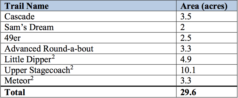
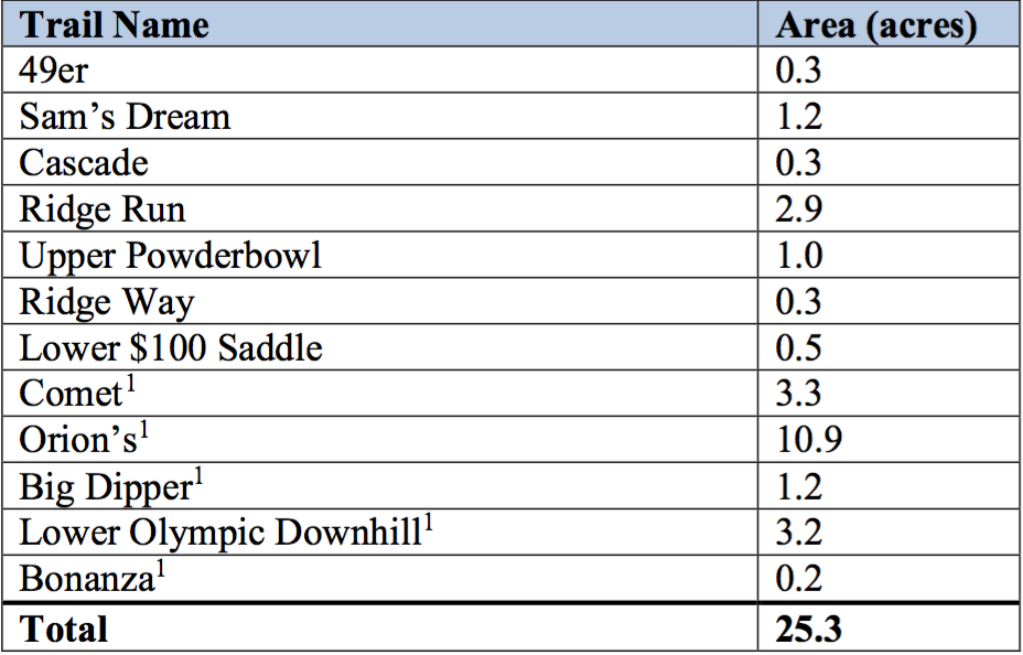
The resort has plans to remove hundreds of trees in a 25.3-acre area for widening, while another 29.6 acres would be part of a ski run hazard reduction area. The exact number of trees will be identified in future environmental documents.

“There are locations on select ski trails across the resort which are not sufficiently wide enough to accommodate the existing use. Based on use levels and patterns particularly in early-season and low-snowpack conditions, these trails are not providing a high-quality experience and cannot be opened on a consistent basis,” the U.S. Forest Service scoping document says. “In addition, there are also locations where boulders, stumps and other obstacles make grooming difficult and require a great deal of electrical energy and water through snowmaking in the early season.”

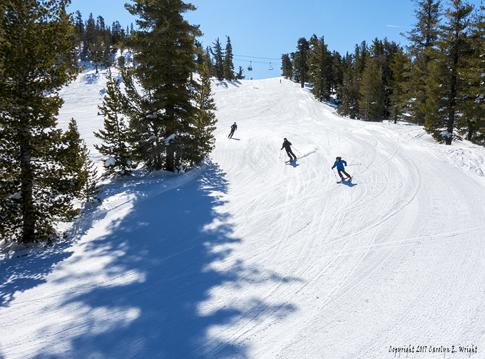
Widening trails could start in spring 2018 at Heavenly. Photo Copyright 2017 Carolyn E. Wright

The U.S. Forest Service, which owns most of the land the South Shore resort operates on, is seeking comments until April 28 on the scoping document. Later this summer an environmental analysis will be developed, which will give the pubic another opportunity to weigh in on the plans.

Matt Dickinson, acting planning staff officer for the Lake Tahoe Basin Management Unit, said most skiers and riders are not apt to notice the bulk of the likely forthcoming changes.

“Some people will notice it in the pinch-point areas where people stop and they’re all jammed together,” Dickinson told Lake Tahoe News. “People will be able to zip right past and not worry about crashing into someone else.”

The changes are part of Heavenly’s larger master plan that the USFS has approved. Each project, though, then needs approval.

The soonest the resort could start on the projects would be spring 2018. All improvements affect winter users of the resort, not summer. The amount of time for completion will be dependent on money and weather. It will likely be a multi-year project.

Kevin Cooper, spokesman for Heavenly, did not respond to questions about the project.

Today, the plan is to remove the trees over the snow. It’s possible some trees will be felled before it snows, but the extraction will be with snow on the ground.

Ski run reduction locations

                   Ski trail widening locations                        Source: USFS                    

“The snowcats have such a light touch on the ground. They really alleviates those (erosion and compaction) issues,” Dickinson said.

In areas where snowmaking lines will be affected, they will be relocated. It’s possible the resort will upgrade those devices where applicable.     

Another component of the project is to make snowmaking more efficient by getting rid of large boulders and downed trees that take several feet of snow to be covered. This is most troublesome in drought-like conditions when Mother Nature is not able to sufficiently cover them, especially in what resort officials and skiers would consider a timely manner.                                               

“The height of these natural features can require up to 5 feet or more of snow coverage before trails can be opened. During low snow years a great deal of energy and water resources is put toward making snow on these trails or else they can’t be opened,” the scoping document says. “Boulders would be capped — blasted with explosives — to a height of 12-18 inches and moved by hand or equipment. Stumps would be ground or cut to a height of less than 6 inches but would remain in place. Large diameter logs would be moved from the ski trail, chipped or used   along steeper sections of trail for erosion control.”


Notes:

·      Comments are due April 28.

·      Email comments to: comments-pacificsouthwest-ltbmu@fs.fed.us.

·      More information is available online.