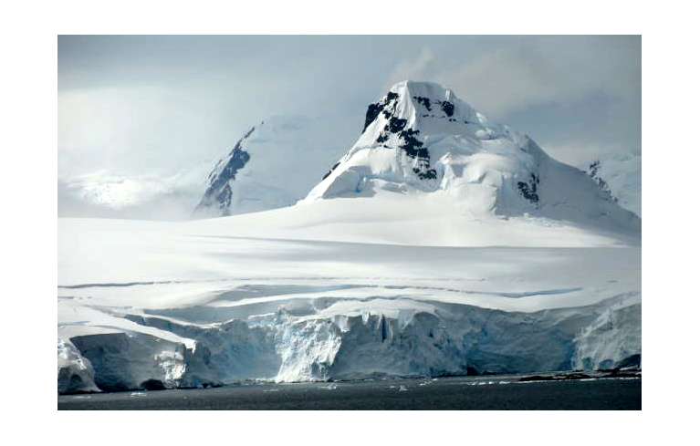
Mountains of Antarctica from a cruise ship. Photos/Robert S. Wood
By Robert S. Wood
I never thought I’d get to Antarctica. Way too expensive, though I’d lived and worked in the Arctic and traveled Patagonia as far south as the tip of South America. I badly wanted to compare the two polar regions, which I knew to be vastly, wildly different.
In the north one travels mainly on land and by bush plane; in the south it had to be by ship or air. But just flying over all that ice didn’t interest me. Tours by ship commonly start at $15,000 per person and as much as $65,000 if you want to actually set foot on land. That’s partly because of stiff entry requirements to prevent pollution like double-hulled ships with a special expensive fuel. And it’s a long way from California.
My wife, Deanne, and I had cruised with Holland America Line (HAL), so we kept an eye on its Antarctic offerings. We spotted a coming three-week cruise in January 2013 that started in Valparaiso, Chile, on the South Pacific, dove deep into Antarctic waters for four days cruising, then sailed north up the Atlantic to Buenos Aires. It sounded good, though way too expensive at $14,500 each.
What especially attracted me was that it cruised the Sarmiento Canal in Argentina where my buddy Jack Miller, with whom I’d camped in Patagonia, had made a handful of first ascents on inaccessible wilderness peaks. I’d always wanted to see those mountains. That made the HAL itinerary sound especially great. So did the dozen of glaciers emptying into the sea along the way.
Fortunately, cruise industry economics make it mandatory to somehow fill every cabin even if they have to cut prices to the bone. We talked to our agent at HAL and he offered us a decent discount, but the price was still way too much. The sailing was still three months away and we expected the price to drop a little further as time grew shorter. But there was always the risk that the boat would suddenly fill up and our chance would be gone.
We had just about decided to save our pennies and wait hopefully for next year, when in late November our agent called us, breathless. HAL was unexpectedly offering a special on “our” cruise. An ocean view cabin, he told us, would cost us just $2,400 each, barely $100 bucks a day. We grabbed it – our Christmas present to each other – and started planning. Bulky parkas wouldn’t fit in our suitcases, so the strategy was to wear multiple layers of thinner winter garments for the warmth we’d need out on deck in Antarctica.
Our American Airlines jet landed in Santiago, Chile, in January, where the suddenly summer temperature was 90 degrees. Coming from winter in the U.S., it felt like our blood was boiling. A bus took us west through farmland for two hours to the seaport of Valparaiso, where we boarded the 1,300-passenger HAL Veendam. The next morning we set sail down the mostly wild Chilean coast of Patagonia, behind which rose the shadowy spine of the Andes.
We had been promised a chance to go ashore at small fishing towns every other day to see the sights, but the notoriously stormy Patagonia weather threatened those excursions. Since the villages were all too small to have a dock that could accommodate the Veendam, the only away ashore was to climb into bobbing oversized lifeboats called tenders and plow through harbor waters to small fishing boat piers.
At Puerto Montt, two days sail south of Valparaiso, we planned to take an 11-hour bus-launch-bus excursion through the remote famed Chilean Lake District. But the captain decided the stormy bay’s whitecaps made it too rough, and we were not allowed to attempt a landing. Sigh.
So we sailed on south. Every day it grew a little cooler, while at the same time the days grew longer as the latitude grew higher. So, paradoxically we got more sun as we approached Antarctica.
In the next four days, we managed to get our tenders ashore at several fishing villages, where we enjoyed barbecued lamb and Pisco sours and wine at one remote rancho/estancia behind the town of Chacabuco. On the way back to the ship our driver stopped at a local market where he helped us buy more wonderful Chilean wine — $30 on the ship — for four bucks a bottle.
Jack had warned us to watch out for the dreaded Trancura Fly, a giant bee native to Patagonia that was extremely aggressive and had a nasty sting.
On a driving excursion on a rocky road in the Simpson River Valley, we stopped to walk to a waterfall when suddenly we were attacked by a swarm of Trancuras. We ran for the van and got inside without being stung, but several bees came in with us and zoomed angrily around inside, everybody cringing and swatting, until the frantic driver could kill the last of them.
The next day, when the captain announced we would be entering Sarmiento Canal around 11am, I made my way with my camera to the highest deck in the bow. Jack’s photos of his climbs in the National Geographic had showed nothing but snow. Now in mid-summer there wasn’t a flake in sight. We did, however, see the impressive Brujo Glacier, with its spawn of ice floes and bergs floating at its foot, as well as the landmark rusty red shipwreck of the Santa Leonor.
Punta Arenas, which I had visited almost 40 years before, had grown from a village to a seaport city. From it, I sent Deanne on a strenuous inland 12-hour bus-flight-bus excursion to see beautiful Paine National Park, a highlight of my trip back in the ’70s. It was a gamble on the Patagonian weather, which thankfully held fair, and she returned beaming but weary with wonderful pictures.
Punta Arenas was our last civilization on the mainland. After that we made our way through thousands of Argentine uninhabited islands, weaving our way toward Tierra del Fuego. The next day we enjoyed a series of blue-tinged icefalls in Glacier Alley cruising through the fearsome Beagle Channel – tame that day as a lake – to the final island, Tierra del Fuego, planning to go ashore at Ushuaia, the continent’s southernmost city that I had previously visited on our ’70s camping trip.
When it came in sight I was astonished. The little village I remembered had also tripled in size into a large town, but again stormy seas prevented us from landing or even tendering ashore. Double sigh.
So we continued south through open empty seas in a twilight that refused to turn to darkness, through the feared Drake’s Passage where the Pacific and Atlantic oceans angrily meet. Our first sight of Antarctica, only hours from Ushuaia, were the black humps of islands that extend out from the tongue of Antarctica known as the Palmer Peninsula, some of which is actually outside the Antarctic Circle.
Everyday now there were several lectures by a pair of Antarctic expert brothers named David and Chris Wilson, whose famed uncle had accompanied the legendary Shackleton in the race to be first to reach the South Pole more than a century ago.
By now it was cold all the time, though the sun never set, and when the wind blew it was decidedly chilly on deck. Fortunately, there were ample heated, glassed in public lounges where views were better than those from our portholes and exposed balconies. Then a thick fog rolled in, obscuring the sun, providing a strange pearly gray lighting affect.
At St. George’s Island on Admiralty Bay we passed three of the lonely stations that are the only man-made sights in Antarctica, beside wrecked vessels. Here, sharing a slightly sheltered bay, were the Polish, Russian and Chilean bases – forlorn clusters of low huts and crude blocky buildings set in clearings in the snow. A few figures in bulky dark clothing could be seen moving like ants between the buildings. Many of them stopped and waved at us, the only signs of distant civilization they were likely to see.
Offshore stood several small supply ships and research vessels. The only other boats we saw on the whole voyage were a big yellow German cruise ship blaring beer hall music and a small sailboat, not more than 30-feet long, dwarfed by the bergs it was sailing amongst. I shivered to think of living conditions on board, compared to our cozy cabins.
Now well inside the Antarctic Circle, the myriad islands were simply mounds and blocks of snow rising from pitch-black seas flecked with ice floes and small icebergs. The only place we saw the black rock that revealed land in that world of white was on slopes so steep that the mantle of snow had avalanched off into the sea. It was a desolate sight that shouted cold, cold, cold. The sun had disappeared the night before behind a layer of fog and cloud that made a backlighted ceiling of gray at about 1,000 feet above the water.
The following day we began to pass bigger islands and more glaciers. It was sometimes possible to see three at one time. The old glacier ice was distinct from the snow by its pure blue glow. Mostly the weather was mild and cold, with low clouds that obscured the sun but revealed the moderate snow-covered dark peaks.
We saw hundreds of penguins strutting comically ashore from a distance through binoculars and dozens more looking up at us on passing icebergs, close-up.
We passed immovable-looking icebergs far bigger than the ship, explaining what had easily sunk the unsinkable Titanic. Often they were larger than the islands and topped with snow, but their baby blue ice looked much different. They rose hundreds of feet above the seas, meaning nearly a thousand feet of ice lay underwater – only the proverbial “tip of the iceberg” being visible. Hitting one would be like driving the ship into a sheer granite wall. Being summer, it never got completely dark.
Obviously, our 1300 passengers could not be taken ashore at any of these tiny stations, but several scientists arrived one morning in inflatable Zodiacs from the out-of-sight Palmer Station, one of three bases run for research by the United States. They delivered fascinating illustrated lectures and told us what life was like in the stations. If you weren’t passionately dedicated, as they were, life would definitely be grim.
These talks supplemented the excellent daily lectures and slide shows by the Wilson brothers and frequent reports on the loudspeaker from the captain, announcing glaciers, whale sightings, penguin colonies, etc., keeping us well informed. While on board the scientists clearly enjoyed basking in our spas and eating gourmet food in our warm dining rooms.
A map of our course looked like a can of worms, as the ship zigzagged among islands. And after showing a landmark to the starboard side of the ship, the captain would rotate it 180 degrees to show the port side cabins the sights.
The Argentine Station sat right next door to an Adele Penguin rookery. That might sound like good company, a source of entertainment, a floorshow for the lonely residents. But there was a price. “Eau de Penguino,” a stink said to clear one’s sinuses, was never absent. We could smell it from the ship. Adele Penguin poop, we learned, is pink, the only color we were to see in this black and white movie of the Antarctic.
As we pushed farther south toward the pole, the pack ice got thicker and icebergs were crowding us as the captain put the Veendam through some narrow straits on the way to Iceberg Alley. Pack ice finally blocked our entry into the Weddell Sea lying east of Palmer Land. At dinner, through the dining room windows, we often were treated to some lovely endless sunsets when the sun sank below the layer of fog and seemed to move sideways.
After cruising Antarctic waters for most of four sunless days, we headed north into the Atlantic, and immediately the sky turned blue and the sun came out. It was fun to run in our robes across the open aft deck and jump laughing into the deck hot tubs, despite the icy wind, to watch the last of the glittering snowy peaks recede in the distance.
We were supposed to go ashore at Stanley in the nearby Falkland Islands, but weather forecasts from there convinced the captain (and his cost-conscious bosses ashore) to cancel that port, too – saving the ship substantial fuel money. Boo! Instead, we sailed into and landed at Puerto Madryn on the flat, bleak Argentine coast, where we got a taxi to take us to an Eco Museum (closed) with its giant outdoor whale skeleton and then on to a lively sea lion colony where the rare giant Albatross flew.
Two sea days later we docked in Montevideo, Uruguay, for a city tour. It was a beautiful European metropolis with many parks and gardens and bronze statuary commemorating its endless heroes. The following day came another city tour, this time of bustling cosmopolitan Buenos Aires whose gigantic soccer stadium, dwarfed most of our football arenas. That evening we disembarked, bused to the airport and began the long flight home.
I had been curious about how the Antarctic would stack up against the Arctic, to which I’d taken two great summer Alaskan trips. Except for the cold temperature, they were different in every way. Back in college a pal and I had built a camp trailer and drove it up the just opened Alcan Highway (then just a muddy trail) to Fairbanks.
There we got jobs in Point Barrow, then the northernmost year-round community in the world at the top of Alaska on the Arctic Ocean, working in the oil exploration camp kitchen and hanging out at the Arctic Research Laboratory, where we got to go on great field trips. We lived in wolf fur-lined parkas, but it didn’t seem especially cold. We worked there two months under the circling midnight sun, enjoying the abundant wildlife (millions of caribou migrating, polar bears, musk oxen, endless birdlife) and the still intact thriving native Eskimo culture.
We loved the vast sweeping Arctic vistas, the lush green permafrost tundra bursting with color, light and wildlife. Contrast that with the Antarctic where the only plant life is rare hair grass and lichen. The ice pack at the mountainous South Pole is over a mile thick, and the only creatures to be seen in that black and white world are penguins and whales.
Then just 10 years ago, Deanne and I rode a series of bush planes from Fairbanks to Gates of the Arctic National Park, where we crash-landed on a sandbar in the Alatna River under the mighty Brooks Range. There we blew up rafts and rafted south through the snow-free Arctic, portaged the rafts over a hill to a large lake where we were picked up by bush floatplanes for the flight back to Fairbanks.
The greatest similarities we found were between the beautiful windswept wonderland of Patagonia, where the natives have been extinct for a century, and busy northern Alaska where Eskimos still exist and still hunt seals and whales.
Of course we only saw a small slice of Antarctica on our cruise, and were unlucky with the foggy ceiling that hid the sun, but when it comes to choosing between which end of the earth to travel, I’ll take the Arctic every time.
Robert S. Wood and his wife spend half the year in Lake Tahoe and the other half in Sedona. He is the author of a dozen books, including the original trail guide to Desolation Wilderness.
ngg_shortcode_0_placeholder (Click on photos to enlarge.)
 It’s a look at four generations of her family – including herself, her daughters, her mom and her grandmothers. It delves into how the women’s movement changed the expectation of women and the options for women.