From olive to oil

By Kathryn Reed

GERBER — Refried beans. Really, that’s what one stage of making olive oil looks like.
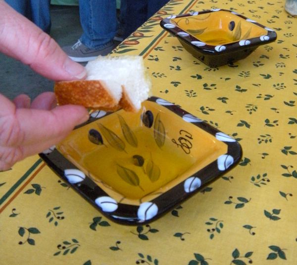
No two olive oils taste the same. Photo/Kathryn Reed

No two olive oils taste the same. Photo/Kathryn Reed

It’s Day 3 of camping, and we find ourselves at a crush party somewhere between Red Bluff and Chico. Joining the four campers are four others who live in the area.

Wine is the first order of the morning (it’s close to noon). For $3, a commemorative glass is filled umpteen times until the driver of the dirty Jeep cuts off her passenger.

New Clairvaux is pouring its wines from Vina. Burnsini Vineyards came down from Cottonwood.

“The heat causes the Petite Syrah to be intense,” Tom Burnham, Burnsini general manager, said of the winery’s specialty.

Sue described the varietal as, “A little peppery, but not as much as the Zin, with a hint of almond.”

I just know I liked it.

This is the fourth year Pacific Sun Olive Oil has opened its doors to the public for a one-day crush party. Each year “Love at First Crush” grows, with 300 people attending last year’s event and 500 this year.

“People want to know where their food comes from. They are getting back to their agrarian roots,” owner Jane Flynn said.

In 2008, the family-run operation bottled 200 gallons of the liquid gold. The crop is smaller this year, so the number of gallons will be less. It takes about 7.6 pounds of olives to fill a 500ml bottle. Olives must be milled within 24 hours of being picked.

The recession has not hurt Pacific Sun.

“People are still eating. They want good olive oil,” Flynn said.

Part of the experience includes watching the “crush” from whole olive to oil. The bottling part is skipped for health code reasons.

Mission olives, a mix of green, red and black, fill 4-foot-by4-foot bins. A bin weighs about 1,000 pounds. Olives are sent up a conveyor belt to sort out debris like leaves.

They are washed with a brush that seems like a car wash for olives.

An auger elevator moves the cleaned olives into crushers. These contraptions are important because the type of crusher can affect the flavor of the oil. Pacific Sun has two different crushers.

The mixture has warm water added to it as the malaxers churn the paste for about 45 minutes.

“The pits, skins and all are in there,” Brendon Flynn, the owner’s son, explained as he kept an eye on the goo that looks like refried beans.

A decanter centrifuge separates the solids from the liquid as it spins at about 3,600 rpm. What comes out is a really unappetizing mixture that looks like someone got ill.

The liquid, which is carmel color at this point, is poured onto metal that has tiny holes on it to again strain the solids.

Then it’s onto another machine where the end product looks closer to something you want to dip bread into or cook with.

When one of the big blue oil drum-looking containers is filled, it’s time to sit for a month or two in a temperature controlled setting before bottling begins.

In another section of the operation is an olive oil tasting room set up just for the party. The four oils go from mild to full-bodied. The first, Proprietors Select, is buttery.

No. 3 was the favorite with most of the gang I was with — Manzahillo. It will be good for dipping and cooking.

Two balsamic vinegars “a dark and blueberry” were also on the table for tasting.

My sister, Pam, had brought me a three-pack sample of Pacific Sun’s products last year. I stocked up on some more while I was there Nov. 8.

Hayrides through the prune orchard are part of the fun. The Flynn’s medium-size orchard is full of prune, walnut and almond trees. The two rows of olive trees are what they used for the initial crush. Most of what is now made into olive oil comes from other orchards.

The whole event — except wine and lunch — is free.

Be careful of strangers taking pictures. Pam and I were on the cover of the Red Bluff Daily News this week tasting olive oil.

For more information, go to www.pacificsunoliveoil.com.

ngg_shortcode_0_placeholder


KTHO — Ask the TRPA

kthoCall in to KTHO FM 96.1/AM-590 (530.544.8255) this morning starting at 10:15 when Lake Tahoe News Publisher Kathryn Reed moderates the Ask the TRPA radio show. Or listen online at www.kthoradio.com.


Girls camping — all about mud and water

By Kathryn Reed

BIG BEND — Stuck Jeep. Bucket boy. Naked boy. Tarp woman. Burney Falls. Hot springs. Fall foliage. Rain. Rainbow. Friends.

It's good to be with friends at times like this. Photo/Pamala Valentine

It’s good to be with friends at times like this. Photo/Pamala Valentine

Just another typical girls’ camping weekend.

With our annual camping trip being pushed from September to November, we moved the sleeping to indoors at my sister’s in Redding. Roughing-it it was not. Comfy bed, long hot showers, full size kitchen, real food, a fire at the flick of a switch — I could get used to this type of camping.

Day 1 started with rain, so we nixed the idea of hiking. Instead, the four of us piled into my Wrangler in search of natural hot springs.

Heading east on Highway 299 from Redding I was reminded of the drive to Sierraville from Truckee — pines and oaks intermixed, open space, natural beauty.

Fall is clearly in the air on this first Friday of November. As the rain descends, it delivers a freshness — almost infusing life into the dying oak leaves that are long past their vibrant yellow and now much closer to brown.

A series of small towns I’ve never heard of roll by on this two-lane road.

We opt to pass our turnoff and head for Burney Falls — a place only Pam had been to.

What a sight.

Water tumbles 129-feet from multiple crevices in the volcanic rock. It’s hard to know where to look because it’s not just one waterfall. One hundred million gallons cascade down the falls each day.

All of this beauty is part of McArthur-Burney Falls Memorial State Park in the Cascade Mountains. It’s on Highway 89, just off Highway 299.

Burney Creek is formed by underground springs. It gets larger as the falls approach. The creek empties into Britton Lake, which is partly inside the state park.

We check out the campground, which is empty except for the deer, just in case we return to real camping one year.

A rainbow appears as we drive, with one end being at a major logging operation — a different pot of gold I suppose.

We continue down Highway 299 toward the town of Big Bend. Our guidebook leads us to a hot springs resort that isn’t open. We go to the next one. Turning onto the dirt road, we descend a bit. I’m hoping no one is coming in the other direction.

Zigzagging between rocks and washed out ruts we hit a plateau. I steer us into a pit of mud. We’re not moving. The Jeep is in 4-low. Time to pile out — all but the driver.

It moves.

Back in go Pam, Darla and Sue. We carry on a little farther until we reach the edge of Kosk Creek.

We toast to having made it. We chat about the tarp next to us that we presume is where naked boy (the guy in the hot spring) is calling home. That was until we heard rustling and eventually saw tarp woman.

Bucket boy beat us to the springs once naked boy and his friend left. We learned to like bucket boy because as a regular he knew to bring a bucket to cool off the springs with creek water.

Sitting on the edge of the creek that leads to the Pit River, the hot springs and surrounding area have a fascinating history that we learn from bucket boy. We learn how the Indians lived on the land. (We passed a Native American cemetery on the way down.)

We learn about the excellent fly fishing, the popularity of this remote hot springs, the planned development of the closed resort, how high school students are bused to Redding.

We soak in the information as our muscles relax.

Soon it is time to leave. We want to test my 4-wheeling prowess, such as it is, in daylight. I bypass the hole I created coming down and was making good progress until the back end started sliding uphill and the front end spun like a stationary bike.

Finally, the Jeep just didn’t move.

Out went the passengers.

This time it took a bit more maneuvering to make it through all of the muck. The slick incline tested me as I jostled to solid ground. The steely look in my eyes proved to my passengers this wasn’t the type of mud bath I wanted to stay overnight in.

All loaded up, we headed back to our campsite with its indoor plumbing, easy to light fire and flannel sheets.

A perfect camping trip.

ngg_shortcode_1_placeholder


Nevada tugging at tourists’ heart strings

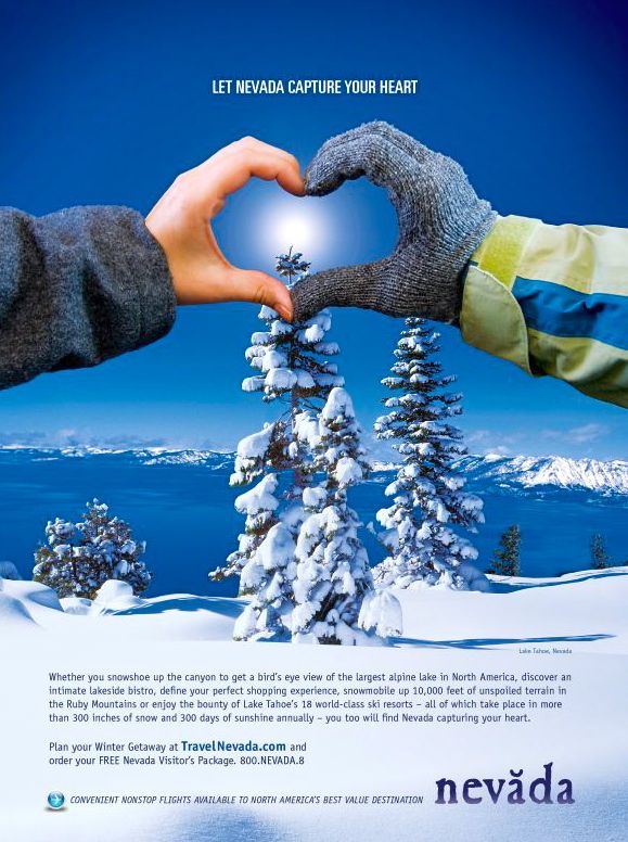
adSmall, heartwarming moments that make a vacation unforgettable are what the Nevada Commission on Tourism’s winter ad campaign hopes to inspire in visitors. The campaign launched this month with a mix of traditional and online media.

“The advertising budget is very small this year, so we are launching a campaign that uses an emotion-evoking image to pique interest, and a complement of TV, print, Internet and mobile media to deliver the details,” Lt. Gov.  Brian Krolicki and NCOT chair said in a statement. “We advertise heavily online because that is where you get the most bang for your buck, and where travelers go to plan their vacations.”

The “Capture Your Heart” campaign targets winter enthusiasts who take at least one overnight ski or snowboard trip a year. The target market is upscale, young at heart and outdoorsy. In order to strengthen Nevada’s presence in its primary markets, especially its ski-season markets, the ads will run in Los Angeles, Las Vegas, the Bay Area, Dallas, Seattle, Chicago and Phoenix through January.

“These markets are very promising for our Lake Tahoe and Northern Nevada winter activities, as well as for the Mt. Charleston and Las Vegas area,” NCOT Director Dann Lewis said in a press release.

The ad at the center of the campaign shows two hands forming a heart and framing a scene over Lake Tahoe. The tourism commission’s research shows that typically it’s not a vacation in its entirety that travelers remember, but rather a small sum of the whole. The “Capture Your Heart” campaign focuses on creating an emotional bond between Nevada and the visitor.


Climbing into a rocky wonderland

By Susan Wood

CASTELLA – Views, views and more views best describes the Castle Dome Trail, a hiking route tucked behind the Castle Crags Campground.

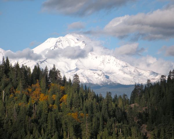
Mount Shasta on Nov. 6 from the Castle Crag trail. Photo/Kathryn Reed

Mount Shasta on Nov. 7 from the Castle Crags trail. Photo/Kathryn Reed

This is Day 2 of our girls camping weekend anchored indoors in Redding.

Just like I remembered, this 5½ mile round-trip trail has everything going for it. The four of us climbed 2,200 feet through an amazing forest filled with birch, dogwood and Oregon ash trees. It crosses the Pacific Crest Trail before launching into a steep incline to a jagged, spire-laced ridge that provides some of the best views Northern California has to offer. To the north, there’s Mount Shasta. Lassen Peak peeks out of the horizon line to the southeast. In between, the sheer drops from the crags bring drama and majesty to the entire hike.

The Castle Crags were created in much the same manner as Shasta and other peaks of the Cascade Range. Volcanic activity millions of years ago along with wind, ice and rain helped to perfect the 6,000-foot granite formations above Interstate 5 south of the city of Mount Shasta.

This is one hike where cameras get as much action as water bottles. As the views open up near the ridge, I pondered how a ridge that is subject to such elements could support exposed, small trees growing from the crevices with no obvious soil to grip. The trees along the trail provided yet another plus for hiking in the offseason — foliage in colors ranging from yellow to pink.

The trail crosses Kettlebelly Ridge, part of the Oregon Toll Road used by early settlers.

At the top of the ridge, the whole world opens up and the main feature of the Castle Crags – Castle Dome, juts out of the landscape. At first glance, some would say it rivals Half Dome in Yosemite National Park. It has no cables to help a brave soul, but even the most experienced rock climber wouldn’t dare go to the top without some sort of technical help like a rope, harness and protection.

State park workers strung a cable across the lookout at the end of the trail, near the base of the dome. But it’s not going to stop anyone from tumbling off the sheer drop off. A fall there would be unforgiving and dramatic.

A safe, flat spot 180 degrees and steps away provides for a magnificent lunch spot with views of the spires, the dome, nearby peaks and Dunsmuir below. It may appear civilization is a world away, but the occasional sound of vehicles rushing on I-5 and train whistles reminds me otherwise.

It seemed difficult to capture the grandeur through a camera lens, but up and down the trail Darla showed how tempting it is to frame the beauty – which led to Kae and Pam getting out their cameras.

Our standard call of “pretty” could be heard all along the way.

Castle Crags State Park takes in 70,000 visitors a year. It features 28 miles of hiking trails, 76 developed campsites and six environmental sites at the campground off the Castella exist on I-5. In mid-October, the state park closes half the campground.

But just this week, the Castle Crags crew rejoiced at having fulfilled its 2-year-old order for seven interpretative signs dotting the region and going up the trail. The signs declare the unique flora, fauna, history, geology, hydrology and wildlife that can be found in Castle Crags. Even the seldom-seen fisher mammal, which resembles a cross between a weasel and fox, lives here.

ngg_shortcode_2_placeholder


CTC burning slash piles

Now through spring 2010, the California Tahoe Conservancy will be burning slash piles in or adjacent to several Lake Tahoe communities as part of the Conservancy’s ongoing program to reduce forest fuels and improve defensible space in the Tahoe Basin.

The communities include Fallen Leaf Lake, Rubicon Bay, Tahoma, and North Upper Truckee in El Dorado County, and Kingswood, Dollar Creek, Sunnyside, Carnelian Canyon in Placer County.

Pile burning is the last stage of the Conservancy’s thinning projects in these areas. To reduce fire risk and impacts on air quality, burning will be conducted only if weather, fuel moisture, and air quality conditions are favorable, an only on designated days in accordance with California Air Resources Board regulations.

Residents and travelers to the area can expect to see smoke from the project areas.

The California Tahoe Conservancy is a state agency that protects and restores watersheds, provides recreational opportunities, and owns and manages nearly 5,000 urban lots and forested parcels on more than 6,400 acres in the Tahoe Basin.

For weekly updates and information on the Conservancy’s prescribed burn activities, phone (530) 542.5580, ext. 3.


Veterans earn their day of honor

By Kathryn Reed

Sacrifice. That was the word that dominated the Veterans Day ceremony in South Lake Tahoe this morning.

Today is a time to honor the men and women who have served in the Armed Forces and those who continue to do so.

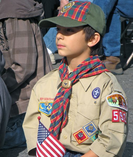
Dylan Martin, 9, at the Veterans Day ceremony in South Lake Tahoe. Photo/Kathryn Reed

Dylan Martin, 9, at the Veterans Day ceremony in South Lake Tahoe. Photo/Kathryn Reed

“There is no mission more noble than serving our country,” said Bill Kerr, a Marine veteran from World War II and Korea.

More than 80 people gathered under gray skies at the Stella Van Dyke Johnson American Legion Post 795 to recognize all veterans.

Legion Cmdr. Blair Clark pointed out that sacrifice is just part of the job when someone joins the military.

Clark presented John Filas with a plaque in honor of the work he does at the Legion that is always appreciated, but not always recognized.

Filas served in the Marines 69 years ago. He spent a couple days getting the grounds ready for today’s ceremony. In the spring and summer he is often out back planting flowers.

All ages attended the ceremony. A busload from Kindertown was there — with handmade red, white and blue hats.

Boy Scouts, too, were there.

Dylan Martin, 9, likes coming to these events. His grandfather served in the military.

“I like that you get to have a chance to observe veterans. It’s a special time of year. You can have a great time, too,” Martin said as he waited for the festivities to begin.


Free subscription to Lake Tahoe News

Subscribing to Lake Tahoe News costs nothing. Your email address will not be sold — at least by the current ownership. You won’t receive spam because of your subscription.

What you will get is a once daily (morning) email telling you everything that has been posted in the last 24 hours. A link is provided to get you immediately to a specific story. A couple paragraphs are included to give you an idea what the story is about.

On occasion you will receive emails about “breaking” news stories. It’s Tahoe — we use “breaking” conservatively because we know you’re busy — even if busy means hiking, biking or skiing. The last “breaking” story was the decision on Johnny Poland.

To subscribe, click here. (Here is the Home page.) Then go to the bottom right where it says Subscribe.

Everyone likes their news in different ways. This method allows you to not have to navigate the website every day. It also gives you the headlines of the past 24 hours.

Thank you for reading Lake Tahoe News. And please feel free to send this to your friends who might be interested in subscribing.

Kathryn Reed, LTN publisher


Prescribed burn in Christmas Valley

U.S. Forest Service fuels management crews will begin prescribed fire operations in the Meyers/Christmas Valley urban lot areas Nov. 12 as weather and staffing allows.

Residents and travelers can expect to see smoke from prescribed fire project areas.

Other fire protection agencies, state and local, may also be conducting prescribed fire operations during this period.

This and other prescribed fire projects are designed to reduce wildfire risks to communities and critical resources.Smoke management is part of every prescribed fire burn plan, and efforts will be taken to reduce actual or potential smoke impacts on community areas.

To learn more about the efforts to reduce catastrophic wildfire risks in the Tahoe Basin, visit: http://www.fs.fed.us/r5/ltbmu/documents/fuel-reduction-projects/10-year-plan/LTBCFP_Public_Presentation_8_3.pdf.


Nevada plate recognizes soldiers who died

“Gold Star” license plates are now available from the Nevada Department of Motor Vehicles. The license plates allow relatives of U.S. soldiers killed in the line of duty to honor their fallen family member. To be eligible to receive the special license plates, the licensee must be a direct relative of a soldier killed in the line of duty.

Gov. Jim Gibbons gave the first two Gold Star license plates to Roger Varela and Sally Wiley at the DMV office in Carson City.

Varela, a Fernley resident and the founder of the Gold Star Families of Northern Nevada, was presented Gold Star license plate 0001. Varela’s son, Ray, was killed near Baghdad May 19, 2007, when his vehicle was struck by an improvised explosive device.

Wiley, a Gardnerville resident, received Gold Star plate 0002. Wiley’s son, Sean, was killed Feb. 15, 2009 near As Salam, Iraq. His vehicle was also struck by an IED.

The Gold Star license plate does not raise funds for any organization. The cost for a set is $1 which is the cost to produce the plate.

The Gold Star plates feature a single gold star next to the letters “FV”, which stand for Fallen Veteran.