Sage grouse now a proxy for control of Western lands

By John Freemuth, The Conversation

The Trump administration is clashing with conservation groups and others over protection for the greater sage grouse (Centrocercus urophasianus), a bird widely known for its dramatic mating displays. The grouse is found across sagebrush country from the Rocky Mountains on the east to the Sierra and Cascade mountain ranges on the west.

This region also contains significant oil and gas deposits. The Trump administration is revising an elaborate plan developed under the Obama administration that sought to steer energy development away from sage grouse habitat. Conservation groups are suing in response, arguing that this shift and accelerated oil and gas leasing threaten sage grouse and violate several key environmental laws.

This battle is the latest skirmish in a continuing narrative over management of Western public lands. Like its Republican predecessors, the Trump administration is prioritizing use of public lands and resources over conservation. The question is whether its revisions will protect sage grouse and their habitat effectively enough to keep the birds off of the endangered species list – the outcome that the Obama plan was designed to achieve.

Sage grouse under siege

Before European settlement, sage grouse numbered up to 16 million across the West. Today their population has shrunk to an estimated 200,000 to 500,000. The main cause is habitat loss due to road construction, development and oil and gas leasing.

More frequent wildland fires are also a factor. After wildfires, invasive species like cheatgrass are first to appear and replace the sagebrush that grouse rely on for food and cover. Climate change and drought also contribute to increased fire regimes, and the cycle repeats itself.

Concern over the sage grouse’s decline spurred five petitions to list it for protection under the Endangered Species Act between 1999 and 2005. Listing a species is a major step because it requires federal agencies to ensure that any actions they fund, authorize or carry out – such as awarding mining leases or drilling permits – will not threaten the species or its critical habitat.

 In 2005 the U.S. Fish and Wildlife Service declared that an ESA listing for the sage grouse was “not warranted.” These decisions are supposed to be based on science, but leaks revealed that an agency synthesis of sage grouse research had been edited by a political appointee who deleted scientific references without discussion. In a section that discussed whether grouse could access the types of sagebrush they prefer to feed on in winter, the appointee asserted, “I believe that is an overstatement, as they will eat other stuff if it’s available.”

In 2010 the agency ruled that the sage grouse was at risk of extinction, but declined to list it at that time, although Interior Secretary Ken Salazar pledged to take steps to restore sagebrush habitat. In a court settlement, the agency agreed to issue a listing decision by Sept. 30, 2015.

Negotiating the rescue plan

The Obama administration launched a concerted effort in 2011 to develop enough actions and plans at the federal and state level to avoid an ESA listing for the sage grouse. This effort involved federal and state agencies, nongovernmental organizations and private landowners.

California, Colorado, Idaho, Montana, Nevada and Wyoming all developed plans for conserving sage grouse and their habitat. The U.S. Forest Service and Bureau of Land Management revised 98 land use plans in 10 states. And the U.S. Department of Agriculture provided funding for voluntary conservation actions on private lands.

In 2015 Interior Secretary Sally Jewell announced that these actions had reduced threats to sage grouse habitat so effectively that a listing was no longer necessary. A bipartisan group of Western governors joined Jewell for the event. But despite the good feelings, some important value conflicts remained unresolved.

Notably, the plan created zones called Sagebrush Focal Areas – zones that were deemed essential for the sage grouse to survive – and proposed to bar mineral development on 10 million acres within those areas. Some Western governors, such as Butch Otter of Idaho, viewed this element as a surprise and felt that it had been dropped on states from Washington, without consultation.

The Trump administration wants to cancel creation of Sagebrush Focal Areas and allow mining and energy development in these zones. Agency records show that as Interior Department officials reevaluated the sage grouse plan in 2017, they worked closely with representatives of the oil, gas and mining industries, but not with environmental advocates.

Can collaboration work?

If the Trump administration does weaken the sage grouse plan, it could have much broader effects on relations between federal agencies and Western states.

Collaboration is emerging as a potential antidote to high-level political decisions and endless litigation over western public lands and resources. In addition to the sage grouse plan, recent examples include a Western Working Lands Forum organized by the Western Governors’ Association in March 2018, and forest collaboratives in Idaho that include diverse members and work to balance timber production, jobs and ecological restoration in Idaho national forests.

There are two key requirements for these initiatives to succeed. First, they must give elected and high-level administrative appointees some cover to support locally and regionally crafted solutions. Second, they have to prevent federal officials from overruling outcomes with which they disagree.

When the U.S. Fish and Wildlife Service announced in 2015 that an endangered listing for the sage grouse was not warranted, the agency committed to revisit the bird’s status in 2020. To avoid having to list the grouse as endangered, the Trump administration must provide enough evidence and certainty to justify a decision not to list, as the Obama administration sought to do. If Interior changes land management plans and increases oil and gas leasing, that job could become harder. It also is possible that Congress might prohibit a listing.

Finding a lasting solution will require the Trump administration to collaborate with states and other stakeholders, including environmental advocates, and allow local land managers to do the same. Then, whatever the outcome, it cannot reverse their efforts in Washington. As Matt Mead, Wyoming’s Republican governor, warned in 2017, “If we go down a different road now with the sage grouse, what it says is, when you try to address other endangered species problems in this country, don’t have a collaborative process, don’t work together, because it’s going to be changed.”

John Freemuth is a professor of public policy and executive director of the Andrus Center for Public Policy, Boise State University.


SLT Library hosting reading challenge for all ages

South Lake Tahoe Library’s Summer Reading Challenge theme is Libraries Rock!

Children, teens and adults are encouraged to participate now through Aug. 31. Register and log activities online.  

Win a prize for every five books you read. The grand prize for all ages is a ukulele.

Special performances will be on Fridays at 2pm in late June and early July. Check out the calendar of events online.


Wildfire Safety Expo in S. Lake Tahoe

South Lake Tahoe Fire Rescue along with multiple local agencies will host the fifth annual Wildfire Safety Expo on June 9.

It will be from noon to 3pm in the TJ Maxx parking lot located at the Y.

The event will include information on creating a home evacuation plan, preparing for fire, creating defensible space around your property and more.

Smokey Bear will make an appearance at this family-friendly event.


Climate change may lead to bigger atmospheric rivers

By Esprit Smith, NASA’s Jet Propulsion Laboratory

A NASA-led study shows that climate change is likely to intensify extreme weather events known as atmospheric rivers across most of the globe by the end of this century, while slightly reducing their number.

The new study projects atmospheric rivers will be significantly longer and wider than the ones we observe today, leading to more frequent atmospheric river conditions in affected areas.

The results also show that the frequency of the most intense atmospheric river storms is projected to nearly double.

Read the whole story


TRPA to host tree service workshop

The Tahoe Regional Planning Agency is offering a tree service workshop from 9am to noon on June 12 at the agency’s office in Stateline.

Topics for the workshop will include:

  • Presentation on how to use TRPA’s online tree removal application tool by Linda Allen, IT systems analyst for TRPA; 
  • Overview of TRPA’s tree removal rules and regulations by Bruce Barr, forester for TRPA;
  • Presentation on creating defensible space to help protect homes and businesses from wildfire by John Pickett, forester for Tahoe Douglas Fire Protection District.

The tree service workshop is free and open to the public, as well as tree service companies, landscape companies, and yard maintenance companies.

Questions about the workshop can be directed Bruce Barr, 775.589.5294, bbarr@trpa.org.


200 Northern Nevada cows missing in a year

By Scott Sonner, AP

Sheriff’s deputies and state agriculture officials are investigating the disappearance of as many as 200 cows in Northern Nevada over the past year that may have been stolen by modern-day cattle rustlers across rangeland covering hundreds of square miles.

Investigators haven’t uncovered any proof that thieves took the animals, but authorities in Humboldt County say it would be an uncommonly large number of animals to have died on the range over the winter.

Fifty cows or calves were reported missing in late March and early April.

Read the whole story


Snippets about Lake Tahoe

·      Lake Tahoe Bird Festival is June 24 from 10am-3pm at Taylor Creek Visitor Center on the South Shore.

·      Toddler Storytime will continue at the Minden Library on Tuesdays at 10:30am from June 12-Aug. 7. Felt board stories, songs and musical instruments are included. This is for ages 3 and younger.

·       June 3 is the annual bike ride around the lake. Highway 89-Emerald Bay Road will experience a two-hour traffic delay just north of Camp Richardson Resort at Baldwin Beach Road.  Vehicle Traffic and unregistered bicyclists will be stopped and delayed from accessing northbound Highway 89 from 6:30-8:30am.

·       The Liberty Mutual Insurance NASTAR National Championships will return to Squaw Valley April 3-7, 2019.

·      The June 11 El Dorado County VHR ad hoc meeting will now be at the Magnet School in Meyers at 5:30pm. 


Tahoe Keys targeting boats to stop AIS spread

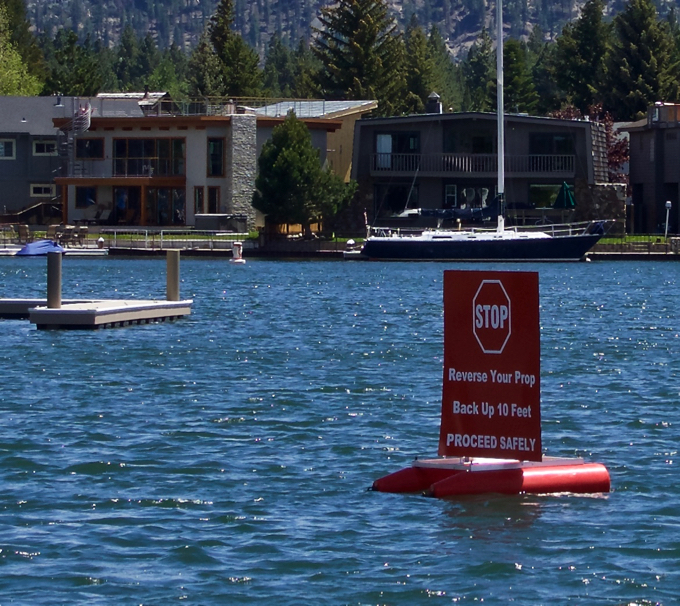
A sign in the Tahoe Keys asks boaters to stop and reverse their motors to dislodge weeds on props. Photo/Kathryn Reed

By Kathryn Reed

Tahoe Keys has set up a high-tech boat wash of sorts in order to prevent more invasive weeds from reaching the heart of Lake Tahoe.

Beginning next week the bubble curtain is expected to be fully operational. This device complements the boat backup station that was implemented two years ago. Sea bins will be added later in the summer as a way to more instantaneously pick up the fragments. Those components are on back order.

Together the goal is to keep the Eurasian milfoil and curlyleaf pondweed in the canals. More than 90 percent of the Tahoe Keys’ 172-acre lagoons are riddled with these invasive species. The Keys is blamed for being the source location for the weeds that have turned up in Lake Tahoe proper. That is why the goal is to stop the spread where it starts.

Skimmers will be used to pick up the fragments the boats discard and then they’ll be removed from the waterway.

Greg Hoover with the TKPOA has his hands full with myriad AIS issues. Photo/Kathryn Reed

New this year are larger signs so boaters will be able to better read what they are supposed to do.

The goal is to have boaters stop, then reverse the direction of the prop. That action loosens and in large part dislodges the weeds that have taken hold.

The drawback to this is that as a homeowners association employees cannot mandate boaters do the backup maneuver. They are working on that. Staff, however, is out there at different busy times talking to people about why it is a good idea to do this and are educating people about aquatic invasive species. They have literature to hand to people to drill home the message.

Once boaters do the prop shimmy they will drive through the bubbles near the mouth of the channel.

“The bubbles should strip off all the weeds that are still attached,” Greg Hoover who manages aquatic invasive species for the Tahoe Keys Homeowners Association told Lake Tahoe News. “We will create a monitoring plan to see how successful we are.”

The bubbles are also expected to create a barrier to prevent weeds from reaching the lake. Boats are the No. 1 way AIS spread from one location to another.

This is the first time the bubbles have been used at Lake Tahoe. At their lowest output the pressure is about 0.5 cubic feet per minute. These types of devices have been used to deflect gas and oil spills from sensitive areas.

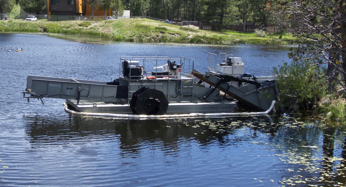
The harvester is like a lawn mower on water. Photo/Kathryn Reed

Regulatory agencies have studied the potential effect on fish and don’t believe it will be a concern.

TKPOA was just waiting on the final sign off from the city to be able to operate the electricity for the bubbles on a 24/7 basis. The apparatus cost about $30,000, with homeowners footing the bulk of the bill and the League to Save Lake Tahoe coming up with about one-sixth.

To create the backup station with signs and designating clear routes for boaters was another $12,000.

Once the sea bins are installed it will be the first time anywhere in the world that they will be used with the bubbles. They will go in three locations acting as a suction that will trap the weed fragments. Then they will be manually drained.

All of this is on the west channel of the South Lake Tahoe neighborhood. The property owners association has control of this area, whereas the marina owners are responsible for the bulk of the waterway near the boat launch.

While all of these devices are designed to keep the weeds in the lagoons, they do nothing to actually get rid of the plants not attached to a moving vessel. The use of herbicide is still very much on the table. It is in the hands of the Lahontan Regional Water Quality Control Board and Tahoe Regional Planning Agency.

Until a decision is made there is still the harvester that essentially mows the weeds.


Opinion: Nevada embraces its trails

By Samantha Thompson

With the passage of the National Trails System Act on June 2, 1968, America received an incredible gift – the creation and protection of extraordinary trails to discover, explore, and connect with nature. With approximately 2,485 miles of national trails throughout the Silver State, the Nevada Department of Conservation and Natural Resources is excited to “wear our hearts on our backpacks” as we join the country in celebrating five decades of the National Trails System.

“In Nevada, our bounty of national trails span every corner of the State, providing vital benefits to our economy/tourism, public health, and quality of life,” said Bradley Crowell, director of the Nevada Department of Conservation and Natural Resources. “Our trail systems are rich with stories, historic treasures, rare species, and unique vistas that make our home State a great place to live, work, and play. We want to congratulate our partners at the National Trails System for achieving this exciting 50-year milestone, and to thank them for their continued support.”

Since 1994, Nevada has received approximately $21 million from the Recreational Trails Program to help fund hundreds of trail systems throughout the State, some recognized nationally for their historic and recreational value.

Nevada’s National Historic Trails

National Historic Trails are long-distance trails (more than 100 miles long), featuring historic routes, remnants, and archeology. With more than 110,000 historic, cultural, and archaeological resources statewide, the Nevada State Historic Preservation Office emphasizes that these trails call to all who want to explore Nevada’s unique history and cultural diversity.

·      California National Historic Trail

·      Old Spanish National Historic Trail

·      Pony Express National Historic Trail

Nevada’s National Recreation Trails

Ranging from less than a mile to 480 miles in distance, National Recreation Trails provide vast opportunities to enjoy Nevada’s precious environmental treasures, unique wildlife, and inspiring vistas.

·      Tahoe Rim Trail

·      Grimes Point Trail

·      Ruby Crest Trail

·      Toiyabe Crest Trail

·      Wheeler Peak Trail System

·      Mt. Charleston Trail

·      River Mountains Loop Trail

·      Historic Railroad Trail

·      Black Canyon Water Trail

From north to south, numerous national trails cross paths with Nevada State Parks, and some areas are also open to off-highway vehicles. The Nevada Off-Highway Vehicles Program will soon unveil a digital, user-friendly geo-mapping system designed to help off-road enthusiasts navigate their outdoor adventures.

Samantha Thompson works for the Nevada Department of Conservation and Natural Resources.


Charter yanking KCRA after election

Charter-Spectrum has agreed to keep KCRA-TV as an option for South Shore subscribers through June 8.

The four-day extension is so viewers will be able to get coverage of the California primary.

Local politicians have been trying to get the cable company to rethink their policy. The company so far is sticking to its business plan.

It all comes down to money. South Shore residents shops more in the Carson City-Reno area than in Sacramento. That’s why the news in a week will all come from Nevada and not California even though some of those viewers live in California.

— Lake Tahoe News staff report