Sandoval mandates body cameras on all officers

By Associated Press

Nevada is joining South Carolina as the only states with laws directing all police officers to wear body cameras.

Republican Gov. Brian Sandoval signed a Democratic bill on Thursday making audio-visual recording devices a standard feature of uniforms for any law enforcement officer who routinely interacts with the public.

It expands a 2015 law directing Nevada Highway Patrol officers to wear body cameras on duty.

Read the whole story


Lake Tahoe’s cold waters can be deadly

By Cate Neal

A plunge into Lake Tahoe can literally take your breath away. It may be warm outside, but the lake can be dangerously cold. Lake Tahoe’s average surface temperature in the summer is 63 degrees, and can drop to 53 degrees just 18 inches below the surface. 

One of the most dangerous consequences of submerging suddenly into cold water is a “cold-shock response.” This response is an uncontrollable gasp for air followed by a prolonged period of rapid breathing. Taking a couple gasps of air underwater is all it takes to drown. Another “cold-shock response” when temperature of the blood cools down and returns to the heart is a heart attack.
So what can we learn from others who take a dangerous plunge? Here are few tips for a fun and safe day at the lake.

Ease in slowly. Take your time getting in the water. Give your body time to adjust to the cooler temperature.

Follow the rules. Swimmers should stay in designated areas. If you are paddling, wear a personal flotation device.  Non-motorized crafts have the right of way, but be aware of power boats.

Watch for obstacles. With the heavy amount of snow we had this winter, you may notice extra vegetation and debris near and along the shoreline. Before jumping into the water, scout out any obstacles and jump in feet first. Whether you are swimming or paddling, know how to look for and avoid obstacles. 

Be weather aware. On Lake Tahoe, weather varies by the hour. Don’t wait for the weather to change. Be aware of your surroundings and know the easiest way to shore.

Skip swimming and drinking. Alcohol impairs judgment and increases risk-taking, a dangerous combination. Even experienced swimmers may venture out farther than they should. A leg cramp can make it challenging to get back to shore and even a chill can develop into hypothermia.

Bring a buddy. Never swim alone. If you haven’t seen your buddy for a couple of minutes, he or she may need your help.

Supervise your children. Keep an eye on your children, especially if they are inexperienced swimmers. If possible, teach your little ones to swim at a young age.

Tahoe summers are a time to be treasured with family and friends. You don’t want to have children on an inflatable flamingo drag you to shore. Swim with caution and enjoy this magnificent lake.  

Cate Neal is a registered nurse and the trauma program coordinator at Barton Memorial Hospital’s Level III Trauma Center.


EDC school population declining fastest in state

By Phillip Reese, Sacramento Bee

Schools in the El Dorado County community of Georgetown thrived a decade ago, with close to 2,000 students enrolled in classes. Today, barely 1,250 students attend Georgetown schools – a number that will likely continue to fall.

New enrollment projections from the California Department of Finance predict El Dorado will lose another 4,000 students in the next decade, a 15 percent decline. No other California county will lose a higher percentage of its students, the state predicts.

School funding is directly tied to enrollment. Fewer children means less dollars, which can mean staff layoffs, service cuts, school consolidation and even school closures.

Read the whole story


NDOT, Waze collaborate to provide real-time info

Nevada Department of Transportation is partnering with Waze, the free, real-time traffic and navigation app, to provide better real-time traffic information.

NDOT state road construction, incident and closure data will become available to drivers on the Waze driver information app. Likewise, Waze will provide NDOT with real-time, anonymous traffic incident and slow-down information reported by Waze users to display on the department’s Nevada 511 Travel Info system.

The data sharing comes at no additional cost to the Nevada Department of Transportation. Waze does not share driver-identifiable information other than what is already made public via the app and live map.

All navigation, even reporting a crash, can be done through voice command, supporting Nevada law prohibiting use of a handheld device while driving.


LTBMU firewood permits to go on sale

Firewood permits from the Lake Tahoe Basin Management Unit go on sale May 30 in South Lake Tahoe, and on May 31 at the Incline Village office. 

Permits cost $20 per cord, with a two-cord minimum and a limit of 10 cords per household. 

Permits have specific conditions. Complete information is provided when the permit is issued. Maps to designated cutting areas are provided and must be in the permit holder’s possession along with the valid permit. 

The permit is for collection of “down-dead” wood in designated areas within the Lake Tahoe Basin. “Down-dead” means the tree is down on the ground and dead, rather than dead and standing. Cutting any standing tree, whether dead or green, is not allowed.

Permit sales will end in early to mid-November.


Snippets about Lake Tahoe

·      South Lake Tahoe’s annual Spring into Summer Kick-Off Party is June 3 from 10am to 2pm. The event is free and designed to highlight summer programs, introduce recreation instructors, and provide tours of the Recreation & Swim Complex.

·      El Dorado Beach boat ramp in South Lake Tahoe is open.

·      Truckee Chamber of Commerce is having a mixer June 1, 5-7pm at Bar of America in downtown Truckee.

·      Truckee’s Fourth of July parade will be from 10am-1pm. Entry forms are online.

·      Here is a recap of the women’s Tour of California bike race, with lots of Lake Tahoe images:


Additional cameras on lookout for wildland fires

By Mike Wolterbeek

With a record mountain snowpack changing to a “robust,” above normal, significant fire potential, wildland firefighting agencies are gearing up for another fire season – and UNR is ramping up its AlertTahoe HD/4K fire camera system, which overlooks and helps protect dozens of western mountain ranges and hundreds of square miles of Nevada’s Great Basin.

The university’s Nevada Seismological Laboratory hasn’t waited for the record Sierra snowpack to melt. They’ve already added two new mountaintop fire cameras to the 29-camera system, on 9,700-foot Slide Mountain on the east side of Lake Tahoe, giving wildland firefighting managers a panoramic view of the Truckee Meadows, parts of Washoe Valley, Lake Tahoe and the surrounding mountain ranges.

One camera will spin 360 degrees continuously, and one will have manual direct monitoring.

The AlertTahoe project, is in its third year.

The Tahoe-Incline, Incline Village, Tahoe City, Rotary Club of Truckee, Truckee Sunrise and Tahoe-Douglas Rotary clubs participated in the Slide Mountain installation.

“The Rotary clubs didn’t just write a check; they actually came with us to the site on Slide Mountain, rode up in our over-snow vehicle and shoveled snow to dig out our building that had been buried in a 20-foot-deep snowpack,” Graham Kent, geosciences professor and director of the Nevada Seismological Laboratory, said. “Coming off a successful season of spotting fires last year, it’s great to get more support. We’re able to start filling in the gaps of coverage. Tahoe Prosperity Center has been critical in finding funding for us to fill those gaps.”

In the weeks following the Slide Mountain install, the Nevada Seismological Laboratory crew installed two more cameras, one on Bald Mountain in the lower reaches of the Sierra Nevada to the west of Tahoe near Georgetown and one on TV Hill near Hawthorne in central Nevada. Both cameras are live and ready for wildland fire managers to use.

The network is built on the backbone of the Seismological Lab’s statewide earthquake network communication system, discovered seven wildland fires in the Tahoe basin in a two-year period and provided discovery, early intel and/or monitoring of 133 others, allowing wildland firefighting managers to move quickly and efficiently assign appropriate resources to each incident.

“2017 is an exciting year to build upon 2016 successes,” Kent said. “In addition to new, continuously rotating cameras, we’ll be working with ITforNature to deploy their machine-vision auto-detect software that is designed to automatically detect and report smoke. We’ll install the software suite on most of our cameras this summer as a trial run.”

The installation is the first of as many as 18 more cameras for the 2017 fire season, including some planned in Oregon and Idaho, as the successful, proven technology is adopted by forest and rangeland fire managers in other states. UNR’s fire camera system is the only one of its kind in the nation using a private high-speed internet microwave communications system for real-time fire-spotting and monitoring. It covers the Lake Tahoe Basin and surrounding mountains, hundreds of square miles of Northern Nevada’s Great Basin and as far south as Bishop in the Eastern Sierra.
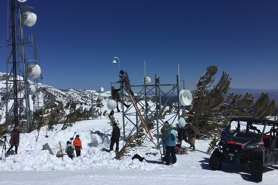
Local Rotary clubs helped fund and install two mountaintop fire cameras in the AlertTahoe network. Photo/UNR

The cameras are used by wildland firefighting agencies for early detection, to spot and track fires, and for quicker, cheaper and more tactical response and suppression. Traditionally, fire managers would send planes to spot and monitor fires, which takes time and resources. They can now use the cameras in the areas of coverage to do the same, as if they were sitting on the mountaintop overlooking the fires.

Last fall, the fast moving Emerald Fire near South Lake Tahoe started at 1:16am. Though no one was watching, the cameras picked up the first signs of the fire 14 minutes before the first 911 call came in, highlighting the need for an auto-detect capability.

“The cameras have to be monitored for them to be most effective,” Kent said. “The on-demand time-lapse video we produce is a useful first step, but we’re excited for the auto-detect software to capture critical intel even earlier. And on the Emerald Fire video you can also see a smaller fire break out in the foreground 1 minute, 45 seconds later. Crews were able to get a jump on that smaller one and put it out before it caused any damage, and the camera played a critical role.” 

There are dozens of examples of the success of the system. The system is monitored by firefighting agencies during fire season. They can manually rotate, tilt, pan and zoom the camera. YouTube channel, nvseismolab, has a library of videos captured from the network.

“Public lands managers are seeing the value in having the rapid look at a fire, as soon as a whiff of smoke is spotted or the near-IR picks up the glare of flames at night,” Kent said. “We can even track lighting strikes, then aim the cameras to see if a fire has started. We’ve been fortunate to have great partners, the BLM, U.S Forest Service and local agency support for land, tower access and funding.”

The Seismological Lab, a public service department in the university’s College of Science, continues to work with the Bureau of Land Management to expand its footprint of fire coverage in northern and central Nevada planning to add up to four more cameras this year to the current nine. Last year, the system helped fire managers get a rapid deployment of resources by being able to show the explosive nature of the Hot Pot wildland fire that at one point was burning at 10,000 acres an hour.

With the private, high-speed internet communications network in place, these sites easily adapt to earthquake early warning detection systems that can provide public notification of expected, potentially damaging ground shaking. The sites can also be used for environmental monitoring research and as extreme weather stations. The university is in a lead position nationwide developing the inexpensive, multi-use, high-throughput, research-grade Internet Protocol networks and expanding their use for all-hazard monitoring.  

“No other system worldwide could actually compete to these standards, as far as we know,” Kent said. “While we’re helping other areas in the West adopt the system, we’ve also had interest from other countries.”

The Tahoe Prosperity Center, a regional collaborative organization, has raised about $150,000 from donors for the system so far. Other areas slated for new TPC-funded cameras at Lake Tahoe this year are Zephyr Cove, Alpine Meadows and Martis Peak.

Mike Wolterbeek works for UNR.


Live Violence Free needs help with post-winter cleaning

Live Violence Free is looking for volunteers to help with cleanup at the South Lake Tahoe facility.

Help is needed with raking, gardening, painting, organizing, and sprucing up the location.

The cleanup day will be June 3 from 10am-3pm. There will be multiple projects to work on throughout the day, for people of all levels of ability and handiness.

Bring gloves and other tools.

Contact Aisling Peterson at aspeterson@liveviolencefree.org or 530.544.2118, ext. 7634 with questions.


El Dorado County explorers capture awards

El Dorado County Sheriff’s Office Explorer Post 457 competed in a statewide competition at the California Highway Patrol Academy in Sacramento last weekend.  

There were 43 explorer posts from across the state consisting of 330 explorers who competed.

Explorers were evaluated in several reality based scenarios including crime scene investigation, traffic stops, active shooter, DUI stops, critical incident, officer needs assistance, building search, California alert system, felony stop, crisis intervention, court testimony, domestic violence, and shooting skills.

The El Dorado team brought home three trophies: fifth place in crisis intervention, fourth place in active shooter and first place in shooting skills.


TRPA floating ideas for pier regulations

By Kathryn Reed

STATELINE – No longer is the number of piers at Lake Tahoe being disputed. Now the debate is about all the strings attached to build one.

The latest plan calls for 10 public piers and 128 private piers, with a maximum of 12 every two years.

The shorezone plan that was adopted in October 2008 also called for 128 piers. That month the League to Save Lake Tahoe and the Sierra Club filed a lawsuit in U.S. District Court in Sacramento to block the plan, citing inadequate science. In September 2010 the decision by U.S. District Judge Lawrence Karlton that struck down the TRPA’s shorezone ordinance was appealed by the bi-state regulatory agency. In February 2012 the Ninth Circuit Court of Appeal gave a ruling that had both sides claiming a partial victory.

For the past 18 months a committee put together by the TRPA, which includes the League and affected property owners, has been working to come up with what is now called a shoreline plan. (The League helped create the 2008 plan and still sued.) The committee’s latest iteration was brought before the Regional Plan Implementation Committee of the TRPA on May 24.

Not everyone is going to get a private dock considering there are more than 700 parcels in the basin without a pier that might want one.

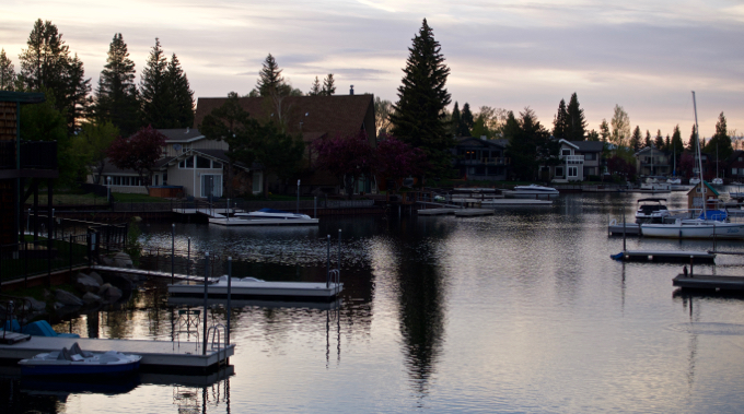
Not much room for more docks in the Tahoe Keys in South Lake Tahoe. Photo/Kathryn Reed

The latest proposal calls for 28 new piers in El Dorado County, 21 in Douglas County, 21 in Washoe County and 58 in Placer County.

Today there are about 800 piers and 4,000 buoys on Lake Tahoe. The 2008 plan allowed for an additional 1,822 buoys. The current plan calls for 1,430 more moorings, which are defined as buoys, slips, or boat lifts.

Density issues will also preclude everyone who wants a dock from getting one. Scenic quality is a top criterion. The goal is not to allow them all to be built in one area, but to spread them out.

How to make it equitable, well, that hasn’t been worked out. There will inevitably be people who lose out on having a pier.

One goal is to have more shared piers. This is intended to reduce clutter and density. A problem, though, could be getting buy-in from neighbors.

“The whole point here is delicate harmonization,” said Gina Bartlett with Consensus Building Institute. CBI was hired by TRPA to work with the shoreline stakeholders to build consensus.

The current plan calls for the pier owner to retire development rights. This was the biggest hurdle for several of the RPIC members. They didn’t see the nexus between the two.

And for those with nothing to retire nor the means to buy other property and have it retired notches up the pier issue to something only the uber-wealthy are likely to be able to afford. Not every lakefront parcel comes with a ton of land.

“We might be creating a situation where only those who can afford to can play,” RPIC member Jim Lawrence acknowledged.

The lack of outreach to those affected is another concern of RPIC. TRPA staff assured the committee they intend to try to connect with property owners.

Obviously there is still work to be done before the environmental document process can begin. The RPIC group is expected to get another update in June.