King Fire growing, Highway 50 closed
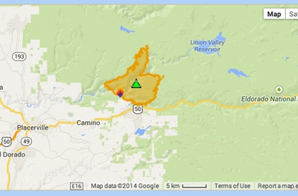
The King Fire is outlined in orange. Photo/CalFire/Google Maps
Updated Sept. 16 11:45pm:
Several new evacuation orders were issued Sept. 16 for people in the path of the King Fire.
Evacuations are now in effect for the Crystal Basin: Highway 50 east of Fresh Pond to Ice House, north on Icehouse to Wentworth Springs, west to just above Quintette to include all campgrounds and businesses.
Voluntary evacuations have been issued for residences south of Highway 50 between Fresh Pond and Riverton, as well as Valconoville. There are 1,632 residences threatened.
The King Fire outside of Pollock Pines as of Tuesday night had burned 12,870 acres, with 5 percent containment. It is burning east, northeast at a rapid rate of speed. Agencies from throughout Northern California are working the fire, including crews from South Lake Tahoe and Lake Valley.
Highway 50 is closed in both directions from Sly Park to Fresh Pond.
The cause of the fire that started Sept. 13 is under investigation.
Smoke from the blaze has reduced traffic along Highway 50 to one lane for several miles. Smoke continues to be a factor in the Lake Tahoe Basin and Truckee, so much so that education officials are monitoring particulate levels to make sure students are safe.
The Seventh-day Adventist Church in Camino is also the evacuation center for people and small animals.
Pollock Pines Elementary School District will remain closed Wednesday.
– Lake Tahoe News staff report