King Fire growing, Highway 50 closed


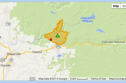
The King Fire is outlined in orange. Photo/CalFire/Google Maps
Updated Sept. 16 11:45pm:
Several new evacuation orders were issued Sept. 16 for people in the path of the King Fire.
Evacuations are now in effect for the Crystal Basin: Highway 50 east of Fresh Pond to Ice House, north on Icehouse to Wentworth Springs, west to just above Quintette to include all campgrounds and businesses.
Voluntary evacuations have been issued for residences south of Highway 50 between Fresh Pond and Riverton, as well as Valconoville. There are 1,632 residences threatened.
The King Fire outside of Pollock Pines as of Tuesday night had burned 12,870 acres, with 5 percent containment. It is burning east, northeast at a rapid rate of speed. Agencies from throughout Northern California are working the fire, including crews from South Lake Tahoe and Lake Valley.
Highway 50 is closed in both directions from Sly Park to Fresh Pond.
The cause of the fire that started Sept. 13 is under investigation.
Smoke from the blaze has reduced traffic along Highway 50 to one lane for several miles. Smoke continues to be a factor in the Lake Tahoe Basin and Truckee, so much so that education officials are monitoring particulate levels to make sure students are safe.
The Seventh-day Adventist Church in Camino is also the evacuation center for people and small animals.
Pollock Pines Elementary School District will remain closed Wednesday.
– Lake Tahoe News staff report

Just contacted a friend near the fire line and he’s been told to get out for a second time now.
The wind changes and the danger returns.
Deja Vu …. from how I remember the Angora fire until the Sheriffs finally told me get out or else.
You don’t want to go unless you really have to – but if you stay you become more of the problem for safety officials.
I have friends in Swansboro. Gotta watch that wind. This reminds me of the Cleveland fire up at Icehouse back in the early 90s.
Report from family in Pollock… fire burned close to Hwy 50 last night close to Fresh Pond. But the crews are dumping water aggressively along the south edge of fire to keep it from reaching the houses in that area (including my families houses in Fresh Pond north of 50).
Also evacuation orders have been given for Swansboro and Mosquito communities.
Need to get back home to Tahoe. Guess I’ll be taking the Jackson route.
My girl works at marshal hospitol. Firefighter told her it is burning out of control to the North. They are focusing air drops on the East side . The fire map on inci web looks scary as crap. Union valley resovoir is directly in its Eastern path.
First, I hope everyone is safe. Wildfires are very scary, especially when the winds are erratic.
Second, I wonder how many of the homeowners in this area were/are against the assesment for firefighting, rural home, fire tax? I bet that little $150 fee is looking pretty good about now as firefighters and equipment save property and possibly lives.
EVERYONE STAY SAFE.
Voluntary evacuation now in Goldridge. That’s bad.
That fire fee did not give Cal Fire ANY additional funding. Why don’t you understand that? Brown took the money out of the general fund that they used to get. It is a political shell game.
And now there is voluntary evacuation from Goldridge. Hwy 50 is closed. I lived there for 20 years. This is bad.
Dog is exactly correct.
just saw on news (reno stations) that hwy 50 is CLOSED in both directions as of 9pm
THANK YOU to all the firefighters out there and any other volunteers too. Our thoughts and appreciation are with you. BE SAFE!
What’s a tahoean?
Here is an enhanced Google map with the King fire perimeter and wind data.
http://www.mappingsupport.com/p/gmap4.php?ll=38.797712,-120.570832&z=13&t=m,Fires,MODIS_thermal,Wind_3hrs_ago&q=http://www.mappingsupport.com/p/fires/wildland_fires_basic.txt
Each time you open this map link it will display the most recent information hosted on government servers and showing (1) the fire perimeter [comes from GeoMAC], (2) MODIS [satellite] hotspots and (3) wind direction and speed as of 3 hours ago. To see the map legend click the link in the upper left corner that says “About this map”.
This map link will work in almost any browser on almost any device. Note – Your browser must be online. If you open this link with a smartphone, tablet or other mobile device then you will automatically see a touch-friendly interface.
To center the map at your location, touch Menu ==> My location (mobile only). The symbol you see on the map will now follow you just like a GPS. Touch the symbol to see the coordinates for your location.
To see high resolution topographic maps, open the basemap menu (button in upper right corner) and select “t4 Topo High” (you might need to zoom in).
If you open the basemap menu and go down to the “Overlay” section then you can turn various GIS layers on/off. A layer with a higher number will be on top of any layer with a lower number. A layer without any number is “off” but can be turned on with a click/touch. Some GIS data only displays at certain zoom levels.
The map is displayed by Gmap4 which is an enhanced Google map viewer I developed.
Gmap4 homepage: http://www.mappingsupport.com/p/gmap4.html
Gmap4 default map: http://www.mappingsupport.com/p/gmap4.php
Joseph e. That is a great map. Are you on the incident management team? Thanks for providing the link
Thank you Joseph E for sharing your knowledge…that is a great map and tool to use!!!